5/25, Saturday. I was picked up from home a little after 9am. I brought the new tent, 2 camp chairs and a camp table which I bought many years ago, but never used. (Verdict: they are all very nice.)
Rained on the way. Once in Cle Elum (gas stop), the sky was less cloudy. Heavy traffic on I-90 due to a multi-car crash, caused a 1+ hour delay :(

 First stop: Lenora Lake Caves.
A picnic table at the parking lot, which we had lunch.
Went to the outhouse, and surprised a snake behind it.
There are a few people, more kids than adults.
Many shallow caves, large or small. Fun to explore.
First stop: Lenora Lake Caves.
A picnic table at the parking lot, which we had lunch.
Went to the outhouse, and surprised a snake behind it.
There are a few people, more kids than adults.
Many shallow caves, large or small. Fun to explore.
 This one on the left is the largest.
Open sky, nice clouds, balsalt columns, very scenic. A bit too late for flowers, but still green. Maybe better early May.
This one on the left is the largest.
Open sky, nice clouds, balsalt columns, very scenic. A bit too late for flowers, but still green. Maybe better early May.
This bug got into the car, when we drove off.
 Next stop is a few miles north at the Sun Lakes Dry Falls state park.
We are to hike the loop of Umatilla Rock, recommended by Ira Spring's 55 Hikes in Central Washington.
The trailhead is far into the park, passing lots of RVs. Google Map first routed through Sun Village Resort, along the road south of Park Lake.
It turns out that this road is gated at the park boundary.
Back on highway 17, take Park Lake Road to Sun Lakes Park Resort is correct.
The "resort"s look horrible to me: very crowded, not much shade, yes, next to water.
This one is better than the previous one.
Next stop is a few miles north at the Sun Lakes Dry Falls state park.
We are to hike the loop of Umatilla Rock, recommended by Ira Spring's 55 Hikes in Central Washington.
The trailhead is far into the park, passing lots of RVs. Google Map first routed through Sun Village Resort, along the road south of Park Lake.
It turns out that this road is gated at the park boundary.
Back on highway 17, take Park Lake Road to Sun Lakes Park Resort is correct.
The "resort"s look horrible to me: very crowded, not much shade, yes, next to water.
This one is better than the previous one.

 I really like this loop. We saw absolutely no one on the trail.
There were some checker mallow near the TH. Bright orange.
The trail was faint half a mile into the grass.
We ended up in a cluster of cabins at one point. Maybe Camp Delany?
All shut. Doesn't seem any of them was occupied.
Some sagebrush still has yellow flowers, a few yarrows and Thompson paintbrush were blooming.
Maybe some Grand Coulee owl's-clover (endemic).
Again should come here early May for better flowers.
The ground is dusty, hidden rocks. Expansive views.
I really like this loop. We saw absolutely no one on the trail.
There were some checker mallow near the TH. Bright orange.
The trail was faint half a mile into the grass.
We ended up in a cluster of cabins at one point. Maybe Camp Delany?
All shut. Doesn't seem any of them was occupied.
Some sagebrush still has yellow flowers, a few yarrows and Thompson paintbrush were blooming.
Maybe some Grand Coulee owl's-clover (endemic).
Again should come here early May for better flowers.
The ground is dusty, hidden rocks. Expansive views.
After about a mile in the basin, saw a track up to the wall of Umatilla Rock.


 Many pink Thelypodium Laciniatum here.
Scrambled up to a notch in the middle of the rock wall.
Very windy at the notch.
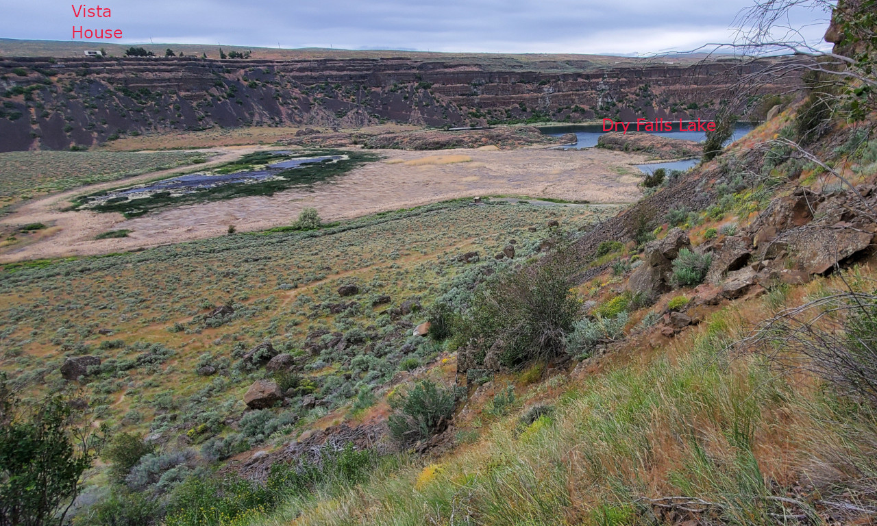
On the west side of the wall, good view of Dry Falls Lake, and the Vista House on the highway.
Getting down to Perch Lake, saw a few cars crawling on a dirt road.
Followed the trail back to the car. A fun loop.
Many pink Thelypodium Laciniatum here.
Scrambled up to a notch in the middle of the rock wall.
Very windy at the notch.
On the west side of the wall, good view of Dry Falls Lake, and the Vista House on the highway.
Getting down to Perch Lake, saw a few cars crawling on a dirt road.
Followed the trail back to the car. A fun loop.
 Drove back on hwy-17, stopped at the Vista House.
Saw more visitors here than inside the park. Excellent view. Definitely worth stopping.
Drove back on hwy-17, stopped at the Vista House.
Saw more visitors here than inside the park. Excellent view. Definitely worth stopping.
Continue driving north towards Grand Coulee. Hwy 155 along Banks Lake is very scenic.
 3rd stop is Steamboat Rock State Park.
We hiked up Steamboat Rock.
Saw quite a few hikers. A bit steep going up.
Ran out of time to walk around on the top of the flat rock.
Attempted to walk to its west edge, gave up after halfway there after the trail disappears.
Might be good to also walk to the north edge.
Very good view of Bank Lake below and the surrounding balsalt walls, as well as the campground (seems nice enough).
3rd stop is Steamboat Rock State Park.
We hiked up Steamboat Rock.
Saw quite a few hikers. A bit steep going up.
Ran out of time to walk around on the top of the flat rock.
Attempted to walk to its west edge, gave up after halfway there after the trail disappears.
Might be good to also walk to the north edge.
Very good view of Bank Lake below and the surrounding balsalt walls, as well as the campground (seems nice enough).
Visited Osborn Bay Campground, but it was full. Drove to the Osborn Bay fishing area east of the bridge on Lake Access Rd. Saw some nice campsites. But all occupied. Soon the road turned to nasty dirt road. Pitched my new Marmot tent under a tree. Even though next to the lake, the access is swampy. My new tent is sturdy and roomy. Very comfortable. Some mosquitoes.

 Once set up the camp, drove to Crown Point for sunset.
On the way, over the bridge, quite a few anglers.
A few minutes too late for sunset. Still bright enough.
Very good view of the dam and surrounding hills from here.
Huge parking lot. A concrete roofed platform with multiple columns.
Many yellow Dalmatian Toadflax (a weed).
Ate belated dinner looking at the dam.
Once set up the camp, drove to Crown Point for sunset.
On the way, over the bridge, quite a few anglers.
A few minutes too late for sunset. Still bright enough.
Very good view of the dam and surrounding hills from here.
Huge parking lot. A concrete roofed platform with multiple columns.
Many yellow Dalmatian Toadflax (a weed).
Ate belated dinner looking at the dam.
Drove down to Grand Coulee Dam's visitor center. At 10pm, there is a laser show (daily, earlier later, as the sunset is earlier). We were early, already a few people sitting at the concrete benches. Walked down to the picnic area. Some people were waiting here. The restroom here is open, and a drinking fountain, where I filled 2 1L bottles, and cleaned up. A few minutes before 10, the dam lets water out. It's fun to see the water draping over each section, looks like a white curtain slowly drawn. The laser show tells a simple story. Very fine lines of color light projected onto the water curtain from the visitor center. Very loud sound, piping out from the many speakers along the edge. Not bad.
Drove back to the camp on the bumpy dirt road. Already sleepy.
5/26, Sunday. Overcast. I got out at 7am (couldn't sleep any more) and set up my never-used camp table and chair. Boiled tea, and laid out food. Looks quite nice. There's no hurry. Wanted to take the 10am dam tour.

 The visitor center opens at 8:30am sharp.
There's a theatre upstairs. Despite of the program list posted at the door, nothing was shown on the screen this early today.
Quite a few things to see. Historical photos and design graphs are fun to ruminate over.
I really like these hands-on projects with reusable legos, pre-wired boards, and batteries.
Detailed instructions. A few projects to choose from. Accommodates 2 in parallel.
The visitor center opens at 8:30am sharp.
There's a theatre upstairs. Despite of the program list posted at the door, nothing was shown on the screen this early today.
Quite a few things to see. Historical photos and design graphs are fun to ruminate over.
I really like these hands-on projects with reusable legos, pre-wired boards, and batteries.
Detailed instructions. A few projects to choose from. Accommodates 2 in parallel.
 Drove to the parking lot for the tour. Too early. I overestimated the demand on this Sunday.
Walked along the bridge, checking out all these posted signs.
Historical photos and descriptions on one side, and gelogical displays on the other.
Drove to the parking lot for the tour. Too early. I overestimated the demand on this Sunday.
Walked along the bridge, checking out all these posted signs.
Historical photos and descriptions on one side, and gelogical displays on the other.
Need to go through a TSA-like security check. Phone, camera, water bottles are allowed, no bags. 2 mini vans waited inside the fence. Our van had 7~8 people, and the other had just one family with 2 small children. Can easily fit another 5-6 people.

 The driver/tour-guide drove us down, crossed the bridge, back to behind the visitor center.
On the way, our driver pointed out the lines in the rocks, all the statistics, the housing, even the grocery store.
TThis is the 2nd largest dam (in terms of concrete) in the world (trailing after China's Three Gorge Dam).
Initially built in 1936-37, with an extension added in the late 60s.
Currently about 500 people are employed here, 10 times more than what I expected.
The driver/tour-guide drove us down, crossed the bridge, back to behind the visitor center.
On the way, our driver pointed out the lines in the rocks, all the statistics, the housing, even the grocery store.
TThis is the 2nd largest dam (in terms of concrete) in the world (trailing after China's Three Gorge Dam).
Initially built in 1936-37, with an extension added in the late 60s.
Currently about 500 people are employed here, 10 times more than what I expected.
Behind the visitor center is another fence, which let us in. Before 911, everything was open to public. No fence at all. We took the elevator down to level 3, to see the pump house, not the power generating rooms. These green cylindars pump water up to Banks Lake, which feeds all the irrigation canals. Also, not used often, as a storage if the water level is low, to feed the generators. The government agency in charge of Grand Coulee Dam is the Bureau of Reclaimation. Its main purpose is to turn the arid area to productive agriculture land.
Stopped at Safeway to stock up cold beer and some food.


 Next, drove to the west shore of Banks Lake to visit the Giant Cave.
Yes, it's a lot bigger than Lenora Lake Caves, but again it's just an opening. The Cave doesn't continue into the rocks.
Bad road for ~2 miles.
Saw quite a few campers out here.
The area is very nice, much larger, quieter than the east shore with all the "resorts" are.
Saw some checker mallow here, and the last few balsamroot flowers.
The scrambling up to the cave is steeper and a bit loose. Not everyone made into the cave.
There was water dripping along the wall, but no actual waterfall that's shown in Ira Spring's book. Maybe earlier in the season?
Very nice and pretty.
Next, drove to the west shore of Banks Lake to visit the Giant Cave.
Yes, it's a lot bigger than Lenora Lake Caves, but again it's just an opening. The Cave doesn't continue into the rocks.
Bad road for ~2 miles.
Saw quite a few campers out here.
The area is very nice, much larger, quieter than the east shore with all the "resorts" are.
Saw some checker mallow here, and the last few balsamroot flowers.
The scrambling up to the cave is steeper and a bit loose. Not everyone made into the cave.
There was water dripping along the wall, but no actual waterfall that's shown in Ira Spring's book. Maybe earlier in the season?
Very nice and pretty.
Heading west. Passing some canola fields full of yellow flowers.
 Next, drove to Chelan Butte TH. A large parking area, lot of cars.
For the interest of time, only went to Elephant Head.
Took the direct strail up, and the meandering trail down. Sandy. Saw a lady fell.
A little past prime flower time, still quite a few flowers left.
Thanks to the clouds, otherwise, this would be a very hot hike.
Ballhead Waterleaf, Mariposa Lily, the last few balsamroot, lupine, phlox, grounsel.
Next, drove to Chelan Butte TH. A large parking area, lot of cars.
For the interest of time, only went to Elephant Head.
Took the direct strail up, and the meandering trail down. Sandy. Saw a lady fell.
A little past prime flower time, still quite a few flowers left.
Thanks to the clouds, otherwise, this would be a very hot hike.
Ballhead Waterleaf, Mariposa Lily, the last few balsamroot, lupine, phlox, grounsel.

 Last, looking for mountain lady-slipper on Icicle Ridge trail, around elevation 2350'.
No, I didn't find them. Instead, found some spotted coralroot at about the same location.
More balsamroot and lupine near the ridge, in good condition.
Lower elevation had tons of silvercrown.
Lots of deep purple vetch.
Finished at 8pm.
Last, looking for mountain lady-slipper on Icicle Ridge trail, around elevation 2350'.
No, I didn't find them. Instead, found some spotted coralroot at about the same location.
More balsamroot and lupine near the ridge, in good condition.
Lower elevation had tons of silvercrown.
Lots of deep purple vetch.
Finished at 8pm.
Camped by Icicle Creek for the night. The creek makes a very soothing sound. Slept well. Rained. My tent held well, large vestibules to cover all the gear.
5/27, Monday. Partly sunny. One big hike. Icicle Ridge via 4th of July Creek. According to the topo map, the elevation gain should be around 4500-4600'.


 Flowers were very good on this trail till ~5000'.
Saw at least two dozens of Tweedy (~3500-5000').
Tons of silvercrown and some chocolate lily at the lowest elevation.
Then, mariposa lily, sicklepod rockcress, phacelia, ballhead waterleaf, lupine and balsamroot in the trees.
Lots of penstemon and Jacob's ladder higher up.
Saw some common alkanet (weed?).
Zigzag more through burnt trees and short shrubs.
Flowers were very good on this trail till ~5000'.
Saw at least two dozens of Tweedy (~3500-5000').
Tons of silvercrown and some chocolate lily at the lowest elevation.
Then, mariposa lily, sicklepod rockcress, phacelia, ballhead waterleaf, lupine and balsamroot in the trees.
Lots of penstemon and Jacob's ladder higher up.
Saw some common alkanet (weed?).
Zigzag more through burnt trees and short shrubs.

 The summit block requires pulling yourself up by holding on to an iron rod, remnant of a former lookout.
 I was lacking energy today. Lagging behind.
Snow is only near the ridge, ~6500'. Didn't need any snow gear. Filled my water bottle with snow.
Had a late lunch at one of those boulders near the summit.
It happens that it's also a home of a colony of lady bugs.
I was lacking energy today. Lagging behind.
Snow is only near the ridge, ~6500'. Didn't need any snow gear. Filled my water bottle with snow.
Had a late lunch at one of those boulders near the summit.
It happens that it's also a home of a colony of lady bugs.
 Back at camp, packed up. By now, the tent was dry.
Heavy traffic along hwy2. Probably 1 hour delay.
Back at camp, packed up. By now, the tent was dry.
Heavy traffic along hwy2. Probably 1 hour delay.