Showing posts with label huckleberry. Show all posts

Sunday, September 28, 2025

2025.9.27-28 Alta Muntain + East Alta via Rampart Lake backdoor

Last fall, one of my favorite day hikes is to Alta Mountain from Rampart Ridge backdoor. Since then, I wanted to camp there in the sea of red huckleberry bushes.

9/27, Saturday. Due to forecast of smoke in the morning, we started late. Quite smoky going through Snoqualmie Pass. By the time we arrived at the TH, I was shocked to see ~20 cars at this "back door". Alas, no longer a back door now.

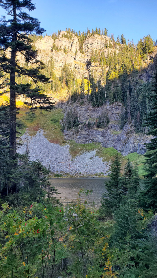
Good fall color at this TH. The trail is still steep and rugged. 0.8 miles 1100' to Lake Lillian.

We took the detour over the big boulder east of the lake. Then walked along the lake for a bit, before going up on a very steep trail to a ridge. Once on the ridge, fall color abundant. Saw a group picking huckleberries. 0.4 miles from the lake to the next junction (according to Caltopo). We took the left fork for Rampart Ridge, passing 2 ponds. They are so small now. Found a fish in the 2nd pond, felt sorry for his lonely existance.

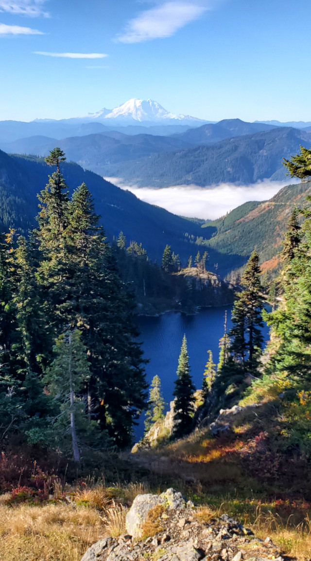
~0.5 miles and 450' later, we arrived at the pass. View down to Rampart Lakes is great. Also high enough to see behind us, Stuart rise above the smoke.

I saw a side trail heading up to the left. Followed it all the way. On Gaia, it was called Point 5870. Didn't plan on this detour. View is great, all the way back to I-90. Hazy there too.

Back at the pass, now scrambling down a talus field. Pretty steep, 0.2 miles loosing 500'. The trail was clear to follow, so not difficult. Soon, we hit the main trail. Soon the first Rampart Lake. There're plenty people and their tents around the lakes. We continued further north but came back to where we saw the first camp site, at the south end of the first lake. Huckleberry galore. After setting up the tent, we rested a bit. AL went for a swim. Then tried fishing. In 5 minutes, he caught a trout! We cooked and ate it right away. Excellent.

A little before 5pm, I headed towards East Alta. Followed the trail to Lila Lake. Before dipping lower to the lake, took the left fork. I was following a trail, sometimes faint, almost all the way. There's one particular short stretch which is steep and maybe only safe on th e trail. The talus area is wide open, but not too long. Good view of Rainier on the way, which was clearer in the setting sun.

The summit is a narrow ridge. Great view all around. I arrived at the summit ~6:30pm, in time to witness sunset.

Back the same way. ~7pm, at the fork of Lila Lake and Alta Mountain, I saw a guy in headlamp, and carrying a big bright something heading up to Alta. Soon I was back in the forest. I also put on headlamp.

Good stars at night. Some large stars in the lake.

9/28, Sunday. Unfortunately more smokey than yesterday. Heading to Alta this morning. Repeat the first mile to get through the Rampart Lakes, the fork to Rachel Lake, and last the fork to Lila Lake. Brillian red of huckleberry bushes. Saw 2 ponds that I missed yesterday. Good view of East Alta, and the ridge.

At the summit, saw the guy I ran pass last night. The big bright object I saw in his hand turns out to be a gallon of water. He was now chopping veggie into his pan and cooking an elaborate brunch. His bright orange tent is the only clear object against the hazy peaks to the north. Not enough space to stretch out his tent. But what a site.

When we were back at our lake, saw 3 guys floating in their blow-out boats. Almost all other tents were gone. We ate lunch, packed up, and hiked out along the regular route. More huckleberries. They were so plump and numerous, that we stopped multiple times to feast on this abundance.

Back at the TH before 4pm. No traffic going back to Seattle. A wonderful trip.

Saturday, September 28, 2024

2024.9.28. Alta Mountain from Rampart Ridge Backdoor

9/28, Saturday. 3 of us met ~6:30am, heading to Rampart Ridge backdoor. Reached the TH ~8am. The last few miles are brushy, some potholes.

There were already some color at the TH. Thick fog hanging in the valley. Quite pretty. The trail is rugged. Half an hour later we reached the junction to Lake Laura. I took the short spur to snap this photo. It's very small.

Continue on, reached Lake Lillian in 20 minutes. Found a couple of tents here. Circling the lake has some problem. These's a faint trail going up into the trees to get around a large boulder. We actually scrambled over on its surface. Needs care. On the way back, we took the long detour in the trees to avoid this sketchy boulder.

At the north end of Lake Lillian, zigzag up a steep hill. Good trail, so no problem. As we got higher, great view of the lake below and Mount Rainier in the distance. Once reached the ridge, need to head left. Somewhat faint trail, but it'll become obvious later. Saw a grouse here. S.W. went over and down the ridge. Me and Aiden followed the main trail. Took us sometime to regroup. S.W. claimed that he found a great campsites. While waiting for S.W. to scramble back up, Aiden coached his g.f. on some of her homework on the phone! Here, huckleberry galore.

Continued on, we met a group of 4 people at a creek crossing. Didn't even notice the trail fork, took the left track into another small lake basin with nice fall color. Would be a nice camp spot. Getting over and steeply down to Rampart Lakes basin. Started seeing many backpackers. Plenty lakes to choose for the night. So many side trails: need a GPS map here.

Passing all these lakes, continue into the trees. A major trail junction (no signs) to Rachel Lake. We stayed straight gaining elevation. Soon can see Rachel Lake below. At the next junction, didn't even see the junction, almost went down to more lakes. Back tracked, going up aggressively for a short while.

From now on, it's on a ridge with lovely fall color, view to both sides. The peak looming head is not Alta Mountain. After this peak, it is a fun, easy scramble. Maybe 0.5 miles. Saw quite a few people both ways.

The summit has plenty space to spread out. Great view, so many peaks, and yes, I-90! Interesting to see where I hiked last weekend. You can see PCT cutting into the slopes to our west. S.W. stretched his Swaraj flag. It took some time. He completely ignored his earlier demand of turning around at 12:30. We left at 1pm.

On our way back, we took the eastern route south of Rampart Lakes. It is quite different, more open, better track. More cloudy though. One section, the color was especially good.

Back to TH ~4:30pm. They decided to stop at North Bend for ice cream. Some traffic on I-90. Back to Belltown ~6:30pm.

This is a keeper. Fabulous color. Not too many people. Plenty tarns and huckleberries. Maybe I'll come backpacking here next fall!

Bright rainbow when I was walking home.

Sunday, August 13, 2023

2023.8.11-13. Perseids at High Divide

8/11 Friday. I wanted to camp away from city light this weekend for the meteor shower. My hiking buddy was needed in office on Sunday, so we settled on Excelsior Pass via Damfino Lake, a short hike to get back out fast Sunday morning.

Headed out at 3:20pm to catch the lightrail. Got picked up at 4pm. No traffic in Seattle, but congestion around Lynnwood and Marysville on I-5. Not sure what's the cause. Wasted an hour on the road, despite of following Google's alternative suggestions: the alternatives were also choked.
Once turned off Hwy-520, I was pleasantly surprised (even though I half-expected it because of some trip report) that Canyon Creek Road (NF31) has greatly improved since my last visit eons ago. The 15 miles (half paved) forest road still has bumps and holes, but now passable by a regular sedan. 3 other cars at the TH, one of thich is low clearance.

We started hiking shortly before 8pm. On the way saw a band of orange under dark grey sky. Damfino Lake area has 3 ponds. The middle one may be all year round. All look mosquito-y. Boardwalk over potentially muddy ground.

We reached the pond at the Excelsoir Pass ~9pm. It's too shallow and small to my liking. We continued towards to the ridge. A tent and 2 chairs took the center stage. Continued over Excelsoir Peak and down to another saddle. Pitched the tent in the ever dimming light. Settled down to watch the sky. I passed out after seeing only one meteor - a shining one.

Total today, maybe 3 miles, 1400'.

8/13, Saturday. Cloudy. One recent trip report on WTA mentioned running water on the south side of Excelsoir. FIrst, I walked south to hunt for water. Didn't find any, but saw 2 nice camp sites (unoccupied). Back to camp, picked up empty water bottles and pouches, and walked back down to the creek we walked by yesterday. I took a shortcut, was cliffed out at one point, but managed to get to the creek much higher than where the trail crosses it.

High Divide is a ridge walk, no tree cover. Thick clouds today provided nice shade and cool temperature for walking. The initial walk is not truly on the ridge, rather on the south side, where the better view is. It's ~4.2 miles from camp to Welcome Pass (drop ~1150' gain ~700'). Passing this brown pond with bear paw prints on the edge. There's a steep trail going down to Hwy-520 from Welcome Pass, if you want a work-out.

Continued on High Divide, soon on a proper ridge, now going north. Only one snow patch left, large enough to last awhile. Refilled my water bottle here. You can see Chilliwack on the Canadia side. No wonder, last night, the sky wasn't very dark.
Took a long lunch break at Keep Kool Butte, our turn-around point, waiting for the sun to shining on the many ponds below Yellow Aster Butte. A few flies. ~1.5 miles, 1000' from Welcome Pass. All morning, we didn't see another human.

On our way back, we met maybe 6 people total. One ask us where is the next water. Saw this cool cave. Didn't peek inside to look for its host. The clouds were burning off, and the sun was shining on the huckleberry leaves. Not many berries or no berry at all. Fireweeds were blooming happily. Other flowers were not doing well here.

Back at camp, we picked up towels and water bottles to go down to the creek. We could see quite a few people on top of Excelsoir. It's good that we camped on this side, so avoided all the day hikers. Checked out the pond first, it still doesn't look nice in the day light. A group was camping south of it in the trees. The creek had a lot of monkey flowers blooming, and valarians. Washed and filled water.

Back at the camp with 4 litres of water. Rest, read my book, hiding in the shade. Cooked dinner (Mexican refried beans and mashed potatos). After 8pm, I headed up to Excelsoir Peak to wait for the sunset. Saw 1 more tent at the pass to the north, and one more with a dog to the south. The setting sun casted a beautiful hue on the landscape.

Clearer sky today. Waiting for the meteors. I fell asleep, but set alarm for midnight. Counted 14 big meteors. Waiting too long for my 15th, fell asleep. My partner said at 2am, the meteors were going every minute, some times more than one on the sky.

Total today ~13 miles, ~3000'.

8/13, Sunday. Sunny. Packed up and hiked down. Started to seeing people coming in. We got back to the car shortly after 9am. Made one gas stop. Smooth sailing. No traffic. Got dropped off shortly after noon.

Took the lightrail, but we were all chased off the train at Capitol Hill Station. Had to take a shuttle bus to downtown. Very crowded. It was getting quite hot. I'm glad to be back before it got hot. I spent the afternoon reading a book. After finishing the laundry, I turned off my water heater. The next week, it was going to the 90°Fs.

Sunday, October 02, 2022

2022.10.1-2 Tomyhoi Peak double take

10/1, Saturday. Met with both NP and her climbing friend BR at Green Lake at 7am. BR drove. We decided to head to Mt. Baker area, hoping that the massive mountain would block some smoke.

Yellow Aster Butte TH. It was so busy, we almost gave up on finding a parking spot and leave altogether. None of us is a fan of crowd. Luckily, on the way down, we found a large enough pull-out to park the car. It was busy for a good reason. The fall color is always amazing here, and it didn't disappoint today, and we could see it from the road.

There's no trailhead parking. From the shaded trailhead, you get on a sun-drenched slope very soon, zig-zagging through fall leaves. ~1.4 miles in, reach a short boardwalk, where a nice patch with plump (rare treat this year) huckleberries. I waited here for NP and BR. BR is very slow going up hill. No one seems to go right at the junction to Tomyhoi Lake (at ~1.7 mile). At the next junction, ~3.6 miles, I waited here again for long enough to take off my boots and socks. My waterproof boots are too hot for this weekend. Going down is to the basin with quite a number of tents. Not as bad as Gothic Basin, but getting there. We filled water here, and took a lunch break. Elevation ~5600'.

Crossed the basin, continued on almost due north, following a trail. First up a fairly steep hill to reach a plateau. A small tarn at the end of a small snow patch, at just shy of 6400'. I put some snow in my water bottle. Saw a dog pee-ing in the water, while the owners stoodby chatting. Unbelievable! There was a tent in the area already, so we continued up, and settling not far up on this plateau. Better view here. Copper Lake fire was spewing in distance. (This photo is BR's.) Quickly I set up my tents, and headed out to Tomyhoi Peak alone, shortly after 3:30. I was afrait if we tried tomorrow together, based on the progress today, they may not make it. I left my ice-axe at the tent, because on the way up here, from talking to those coming down, we learned that the glacier can be entirely avoided. Just in case, I took micro-spikes along.

It took me ~1 hour to get to the snow/ice. It was straightforward with clear trail to follow, up to this point. Quite some ups and downs though. This ridge is after a somewhat steep drop of 200', and then up.

On the way, one Indian guy was very kind showing me his photos on the route he found. He said it took him 45 minutes to find a good route. First stetch of snow, I squeeze between the moat and rocks, then on to some snow, both very short. See the bottom left of this photo to the right in portrait.

Then I saw a blacked foot track on snow further, recognized what the Indian guy told me. So I went down towards it. See this photo I took the next morning, and our track. However, I couldn't figure out which "flat slab" he mentioned, let alone how to get there. I tried 2 gullies (the left 2 red track on the left photo). The first I tried (the middle red line) had a little bit overhang. I didn't try harder, and went to the 2nd gully (the left red line). I made it up, but it felt sketchy to me to come down there. In the end, I return along the right red line I drew on the photo. This matches the description of the Indian guy's "flat slab".

Once I reached the ridge, a little to the right, I saw a cairn, and a trail! It's more or less flat for a while skirting to the left side of the rocky spine. Met 2 climbers on their way back, and inquired the condition. They told me that the cairn is where I need to go down, and going further, more up and downs, but mostly with good hand-holds. From then on, I was the only person on the mountain. I reached the summit shortly before 5:40pm. The view is fabulous, but unfortunately hazy to the north. Took a few photos, and headed down just before 5:50pm, because I need to be back to safety before sunset.

On the way down, I took a sharp turn at the cairn. There is a gentle ramp, more fitting for the Indian guy's description. From there, it was a bit slippery to get down to the blackened snow. I put on spikes, as I was afraid of that it may become icy as temperature dropped. Also, this short stretch is a little steeper, even though I walked in (slowly) just in boots. The sun set on my way out. All was very pretty in the glowing low light. Saw a group of folks admiring the sun and they asked if I made to the summit. "yes!"

There is a small shallow pond at the bottom of a snow patch. I cleaned up a bit there before continued to the camp. I reached ~7:15pm, already pretty dark. My teammates had fetched more water for me to cook dinner. We discussed the route, and I promised to be the "guide" if the condition is good tomorrow.

~11pm, I was up for a bio-break. It was very smokey. I was glad that I climbed today.

10/2, Sunday. The smoke was gone. No wind at all. NP asked us to be ready at 6:30. BR was slow, and we left shortly before 7a. Sun rose as we went higher. Very beautiful. We were the only people on the mountain. Today, it was hazy to the east, more clear to the north. Huckleberry leaves were shining.

We took my return route up and down. They stowed their packs and hiking poles at the end of the black snow. NP had a bit trouble with the loose slab (difficult) and the short knife edge on the rocky spine, which didn't occur to me to be difficult. Exposure, yes, but solid.

We made to the summit just before 9:30am. Lingered here for half an hour, no rush. On the way back, met one guy solo on the top ridge. He came up from a different gully. I took this photo, circle the guy on the climb. Yes, from this ridge, you drop down equally steeply, and then climb up steeply. Looks scary, but feels okay. Good hand holds.

When we were back to the safety, saw a couple trying to scramble up. Then a large group of ~20, none had helmet. Someone recognized my voice, it turns out to be ZY from my last Enchantment scramble. I chatted with her and detailed the route we took.

Back at camp, BR was again very slow in packing. We hiked down a little after 1pm. Waited at the trail junction long enough so I can air my boots and socks. We stashed our packs here, and headed to Yellow Ester Butte.

I cannot believe that I never walked along this ridge before. Yes, need to drop down from Peak 6178 (which I usually turned around, as many others). The trail continued all the way to the rocky peak at the end of this ridge, a little bit of scramble at the end. View of Tomyhoi to the left, and Larabee and American Border Peak to the right. Took this photo on my way back.

Good color on the slope to Peak 6178.

Stopped for ~10 minutes to pick huckleberries at the patch by the boardwalk. Smooth sailing driving back.