Sunday, June 27, 2021

2021.6.26-27 Robinson Mountain in extreme heat

Excess heat was in forecast this weekend throughout WA and OR till Monday. heat forecast. This screenshot was taken on Friday for Seattle. It turned out even hotter than the prediction. According to Komo News on Monday, the hottest day ever in Seattle history was Sunday at 104 degrees. Monday would reach 108F!

6/26, Saturday. 5 of us met in Lynnwood at 5:30am, and headed to Robinson Mountain in 2 cars. The hike leader R specified "strong and skilled team". So I wasn't sure if I'd be okay. I rode with S and Ir. I've only met Ir before, she's older and slower than me, but has been to all major volcanoes in WA. At least I wouldn't drag the group behind. However, it turned out that the heat rendered her so slow that it nearly caused a disaster.

Robinson CreekRobinson Creek bridge 1Robinson Creek trailhead is almost 4 hours drive from Seattle. Not too many cars here. The creek is a few steps away and Methow River is close by. The trail starts road-like. It crosses the creek twice, on two bridges, so not easy to fetch water. There's a smaller creek crossing between the two, where you can refill. Somewhere there, Ir said she's feeling week, would like to go back and wait for us. With the heat wave coming, this is not good. We each took some of her gear and let her lead (to set the pace). At least she'd have a cooler night at the camp (~6800').

Immediately after the 2nd bridge (~2.8 miles), turn right, uphill onto Beauty Creek trail. Steeper, less shade, getting hot. At the end of the official trail is a flowering slope. Just before that is a creek crossing, where we had lunch and refill.

An obvious track is at the begining of the flowering slope. It's steep, no shade, getting hotter. Once the steepness eases, the trail becomes faint. Just keep the creek to your left, and continue straight. Larches, glacier lily, shooting star, then snow.

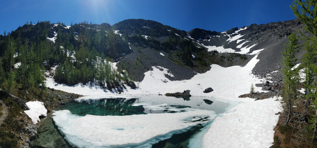
The tarn at the end of the basin was still mostly snow covered, but the area for camp was mostly thawed. I found a small patch of snow and pitched my tent. Cooling off by the lake. Saw a couple slding down the steep scree to our right. Inquired about the conditions. Many larches, but the trees are small, so not much shade. As soon as the sun dropped behind the ridge, the temperature dropped to pleasant level. I was actually a bit cold in my 45°F sleeping bag. Lots of little biting flies. So we hid in our tents. I read a bit and went to bed early.

sunrise6/27, Sunday. Got up early and started hiking at 5am. Pleasant temperature. 
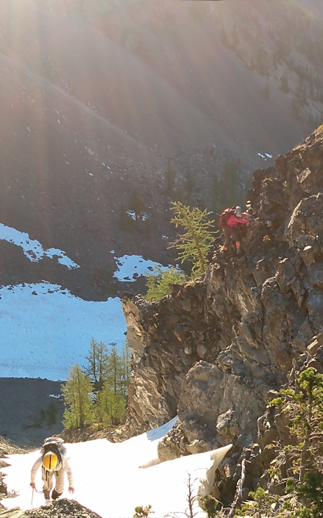
We went up to our left, reached the south ridge of the SE Peak. I took to the snow with ice axe, my team stayed on the rocks. The view on the ridge is excellent. Still many pesky flies. fliesFrom here, the ridge walk is fairly straightforward. We stayed on the west side or on top. Only one minor scree to cross, which on the way back I took to the ridge proper, much easier.

Drop down a bit after the SE Peak. Two stretches of last snow clang to the east slope of the ridge. I was able to fill my water bottle with snow. steep false summitThe false summit is the best part of climb. Steep but solid rock. Robinson Mountain summit markerReached summit at 7:45pm. Once Ir arrived, R brought sake to toast the success. They all signed the summit registry. Robinson Mountain summit

We headed out at 8:30am, hoping to beat the heat to the car. Retraced the ridge back to the SE Peak. Here we took the SE ridge instead. A group of trail runner coming up along this ridge. At its lowest point, I had trouble going down the steep scree, especially the upper half. Met 2 people coming up here. I think I'm the worst of our group on scree.

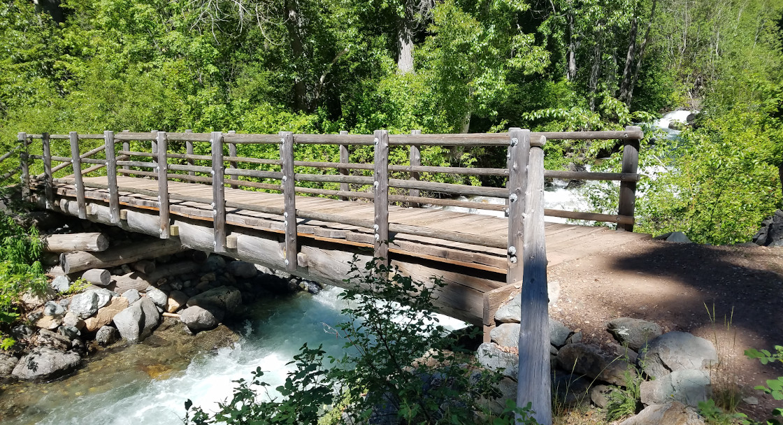
Packed out. We waited, and I read my book. I stayed behind with Ir because of the trail was faint. We headed down at noon, already warm. At the creek below the flower slope, S waited for us. We took some gear from Ir's pack, and filtered water for her. Then 3 of us walked out together. But soon the distance between us streched out. From here down, the trail is straightforward. So we didn't worry. I found S waiting by the 2nd bridge in the shade. I took a photo of the waterfall behind the bridge, and then took my book out and waited for Ir. S went ahead to the car. I checked the time once awhile (the timestamp of the photo was 3:52). At 4:40, I thought Ir passed the bridge without seeing me in the shade, so rushed out. By then, everything in the sun was baking hot. I reached the car, saw a note on the window. Found my group chilling by the creek, a few cans of sparkling water sitting in the water, and a watermellon. Ir wasn't here.

About 6pm, sensing something went wrong with Ir, R and E went back up the trail to look for her. Soon I heard noise and found 2 EMC cars arriving in the parking lot. Someone has dispatched search and rescue. I talked to the 2 rescuers from these cars. They informed me that a group of mountaineers behind us found Ir lying on a log by the trail about 2.5 miles in, unable to move her hands. They poured cold creek water over her, forced her to drink and called 911. Soon one of them hiked out saying that Ir was in a bad shape, then another one told us she threw up. Around 7, they all walked out together. What a relief. Ir seemed in good spirit. The ambulance checked her thouroughly, and released her. After watermellon, we drove back with her fallen asleep in the car. Then S drove her home. On Monday evening, S and a friend went back to P&s;R to deliever her car. I forget Ir's gear in my backpack, and delivered on Tuesday morning. What an ordeal!

Many lessons:
  • always keep group members in sight
  • make sure everyone in the group has similar strength and skill
  • heat is a factor when calculating schedule

Sunday, June 20, 2021

2021.6.20. Pratt Mountain, Rainbow and Island Lakes

6/20, Sunday. For a short day, I decided to scramble to Pratt Mountain, because I really liked it last December. Now with snow mostly gone, it envolves more bushwacking. Yes, winter is better for this one.

Talapus LakeAfter dropping A off at the airport, I drove to Talapus Lake TH. Arrived around noon. I was lucky to find a car pulling out, so got a spot right next to the parking lot. This is a busy trailhead: a lot of cars lining up the potholed road. Talapus Lake is less than 2 miles in. I took to its left shore, no one came this way (all crossed the bridge and continue on the main trail. Both Gaia and Caltopo show a trail connecting the two at the lake boundary. There is NO trail. I gingerly walked over logs that are choking the lake outlet.

Pratt Mt. view to the south Saw a couple of people walking out with large packs. One couple camped at Olallie, another at Pratt Lake. Pratt Mt. view to the north One lady told me that there were mosquitoes, but they were not biting. Before Olallie, I took the slope on the left. 400 or so feet later, cross the trail to Island and Rainbow Lakes. Continued up, in less than 100' reached the ridge. But very little snow left. Scrambling along the ridge is a chore now without the snow. Dodging trees without good foothold. It just gets tedious. The upper ridge is a boulder field. Some snow on its north flank. Scooped up some to my water bottle. The view is very good, but not as good as in winter. You can see Island and Rainbow Lakes from here.

I didn't want to retrace my route along the bushy ridge. Opted to go down the south slope to hit the trail, and visit the lakes. Once hit the trail, followed it west. The lake basin was still snow covered. There were melted footprints towards Rainbow Lake, so I followed. The lake was melted on the edge and mushy on surface. Quite pretty. There's supposed to be a backcountry camp here. I didn't look for it. Retraced my track a bit and went to look for Island Lake. No prints here. A couple of small tarns on the way. You could see Pratt Mt behind me. Island Lake is bigger. Its outlet falls down steeply towards Talapus. I could hear the waterfall, but couldn't really see it.

Back on the trail, scrambled down towards Olallie Lake. 6:45pm already. The lake was in the shade. I didn't see any campers tonight. It's good to visit around this time (instead of on my way in): quiet. From here on, it's on trail. Easy going. Still a few cars at the trailhead.

Saturday, June 19, 2021

2021.6.19. Mount Dickerman

6/19, Saturday. A very different hike than last Nov: still spring condition, lots of snow. This is a large group, ~15 people and 2 of these came from Portland area! Not sure if it's worth the long drive. 3 of us carpooled from downtown and met the rest in Granite Falls. The large parking lot was 3/4 full around 9:30am. Surprisingly I saw P and his friend getting ready for the hike. I hadn't seen the guy for maybe 10 years.

Mount Dickerman is a popular trail. Always in good condition. Saw fresh cut logs. There's one creek crossing that may slow people down, but not difficult (hands are not really needed). See photo. After that, soon solid snow all the way. Snow was soft and easy to tread, despite of some steep but short sections. I didn't bother putting on any traction device, so ended up to be the first of the group.

Too cloudy, the view wasn't good today. By the time the last in the group arrived, the clouds have obscured everything. Of course, when we arrived back at the parking lot, there was more blue than white in the sky.

I put on microspikes before going down, and glissade 2 short sections. On the way, met P and his girl friend again. They gave up on the snow, didn't make to the summit. I rode back with S who was returning his rental car at downtown, because half of the group decided to dine together.

Sunday, June 13, 2021

2021.6.12-13 Grindstone Mt - Icicle River

6/11, Friday. Rained all afternoon. O.K. from Oregon arrived in Seattle. We had finally settled on climbing Grindstone Mountain west of Icicle Ridge on Saturday as a day hike, because of the wet forecast starting Saturday evening. I downloaded GPS track of June 2013, the only track this season.

Chatter Creek trail6/12, Saturday. Headed out Seattle before 7am. We went very slowly on the gravel road, as her car is brand new. At the Chatter Creek trailhead, O.K. took great care to cover our camping gear in the trunk, so nothing is visible. About 6-7s in the parking lot, which can fit ~20. Elevation ~2600'. A handwritten sheet of trail report at the signpost: mosquitoes are out!

crossing Chatter CreekThis trail, even though the same area as 4th July trail 2 weeks ago, the flower here is bysmal in comparison. 3 tigar lily in bloom near the trailhead (a few more in buds later on), saw 3 fairy slippers later. Paintbrush is not bad (yellow, orange and red). Some lupine and balsamroot. The trail is not close to the creek. At ~4400', crossing Chatter Creek is a bit tricky. Close by has a few campsites.

Patchy snow started ~5000'. Less mosquitoes then. Flatter, a few down logs. Thanks to the footprints, we never got lost. Once above the trees (~5500'), saw a couple running down. Sunscreen. Around 6400', we followed the footprints west traversing the slope, instead of going up the regular Chatter Creek trail north which we didn't see footprints. We got to the pass west at around 7050'. The view here is very good, windy. I was quite hungry by then. So we sat behind the rock and I consumed a sandwich.

Going down the west side is a bit sketchy. Snow was thin at times that I could see the dirt. (On the way back, I stayed a bit more north with deeper snow.) I down climbed with ice axe on my right hand, and left hand digging into whatever snow I could find. Thankfully, only about 100'. Then traverse a somewhat steep slope, but with good footsteps. O.K. didn't bother to put on micro-spikes (she even brought crampons, but didn't use any).

Around here, we met a group of Seattle Mountaineers (5 people) coming down. Inquired the condition. There's a short rock pile amidst snow field. The very top are rocks. O.K. went on one, and realized it's not the highest. The rock is an easy short scramble, it is grippy. We left ice axe at the base of the rock.

The top doesn't have much room, but enough for 2 of us. There's a registry, and O.K. signed it. Took many photos. Her new phone has much better lenses.

Coming down the same way. Met a group going up. Below the pass, we continued north continuing on the snow slope, hoping to find a way to Cape Horn. We scrambled to a different pass. It's steep on both sides, and no footprints we could see below us on the regular trail (~500' below). It was 5pm, so we decided to head back. Met a couple going up, saw 2 tents in the woods later.

There are actually two different camps right by the trailhead parking lot. One can pitch at least 4 tents, the one closer to the creek is smaller. It stayed dry all day, until the next morning.

6/13, Sunday. Drizzled a little in the morning, off and on. O.K. wants to stay low. We tried Icicle Creek trail. First, the road to the trailhead has Black Pine Creek flowing over the pavement. No wonder, the parking lot was empty. At the signpost, a piece of paper showing the broken bridge at mile 1.5. We decided to go take a look. The trail doesn't see Icicle Creek at all, until this camping area just before the view point of the confluence of French Creek and Icicle Creek. The bridge over French Creek is indeed in bad shape. Doesn't look safe. We returned.

Next, we hiked Icicle Gorge loop. We started at Rock Island Campground. There's a portable water spiget close to the road. Saw a group of friends walking over the bridge in T-shirt and jeans in light drizzle. Other than 2 umbrellas, one girl had a shopping bag on her head. We crossed the bridge (Icicle Creek Road), took the north bank east first. Half a mile east, at its junction to the NFD-615, has a good patch of paintbrush.

There are many bridges along the loop, tiny ones that are completely unnecessary. The red bridge over Icicle River on the east end is a very nice one. The gorge is not very gorge-like. Pleasant enough, and easy walking. Quite a lot of people, including kids. There's a nice over-engineered lookout on the north bank, where we took a snack break. The trail on the south bank goes right by the road twice.

Got back to the car a little after noon. Headed back to Seattle. We stopped by my camp 2 weeks ago. I forgot my towel on the tree. But didn't find it. On this drizzling day, we took Hwy-2. Not much of a traffic jam. I drove, and O.K. took a nap. She woke up at the red light at Gold Bar, and saw the sign to Wallace Falls State Park. So we went there. It was raining a bit more. The parking lot was nearly full. It happens to be a free day. The powerlines were making more noises. Only went to the first lookout. It was raining harder and harder. I drove home, arrived around 7pm. O.K. continued south to her home.

O.K.'s photos.

Wednesday, June 09, 2021

2021.6.9. Building burned near Space Needle

I walked on 5th ave, and saw the vacated building in smoke. 2 fire trucks, streets blocked. Used to be Polly Esther's Culture Club. A couple of days later, all I saw was a pile of rubble.

Sunday, June 06, 2021

2021.6.6. Teneriffe

6/6, Sunday. Took Trail Head Direct bus (after 1 year of hiatus, it just resumed this weekend) to Teneriffe TH. I and 2 others took the very first bus in the morning at 7:45am (it was 5 min late). There were already 5-6 onboard. The small bus can be said full (50% seats blocked). No one got onboard at Eastgate and North Bend. Teneriffe is the first drop. The large parking lot was ~1/3 full, despite of the looming rain.

The trail to Teneriffe Falls is straightforward. No snow until maybe the last one-two hundred feet. By then, it was snowing, lightly. The summit block is bare, plenty space to sit and if better weather, enjoy the view. No luck today, of course. At least not windy (was a bit breezy yesterday). Coming down on the compact snow, even though not long, is a bit slippery. I didn't put on spikes (did bring them), so was as slow as going up. Once back to the waterfall, all is easy.

Without a car, I decided to catch the bus at Mt Si trailhead. After crossing the creek below the falls, I found a group of 3 hikers looking for the connection trail. It's there, just not obvious. I didn't have touble following the faint trail. This big bridge is very close to the parking lot. I haven't been here for 10+ years, surprised to see such a big parking lot, or rather 3 parking lots. Waited 20 minutes for the bus.

The bus is quite convenient. But weekend and holiday in summer only. Next time, if better weather, will loop to Dixie Peak, Blowdown and Si.