Time to see larches turn golden.
Taking 3 days due to the long drive to the Sawtooth Wilderness.
Ever since I saw Star Lake (2021), I wanted to camp there. Here's my chance, despite of potential snow Saturday evening.
 10/4
10/4 Saturday.
I slept over my alarm, got to my meeting spot an hour late! Sorry.
Driving along Hwy 20, stopped at Diablo Lake Overlook for lunch.
It's always a beautiful sight, even though the water level is low now, and cloudy today.
Less dramatic now, because the snow had mostly disappeared from the peaks.
No rush, 1 gas stop and 1 lunch stop. After almost 5 hours, we arrived at
West Fork Buttermilk TH.
I was horrified to find 36 cars!

The trail goes through a long strech of burnt area. Practically flat.
The burn was old, tons of fireweed now covering the valley floor and slope.
The SW (right) side is steep with giant boulders stacked on each other.
About 2 miles in, there's a large rock slide area, probably due to the burn.
The trail is easy to follow. Saw freshly cut logs - thanks.
On Caltopo, it shows a dot-dot unmaintained "Oval Peak Trail". That does NOT exist.
Saw a couple of small groups hiking out, including one guy with a saw to clear the trail.
Maybe 6-7 cars of people left the trail: still ~29 car-load on the trail, most likely camping at Star Lake.


About 7 miles and 3000' from TH, we reached Fisher Creek Pass (~7500'), in time for sunset.
Started to see larches ~6500', and they were thick ~7000'. The last half mile is lovely.

From the pass, the lovely Star Lake meadow is below, many peaks beyond.
As we descend the pass, we started to hear people talking, dogs barking, and many tents.
It was like a village.
It's a large area, by the time we picked a site for the next 2 nights, it was dark. Gee, it got dark quickly.
AL went for a brief swim as the temperature dropped.
I just wiped myself with towel, and laid my wet towel on a larch to dry.
Hung the food on the only green tree nearby.
Crawled into my 0F sleeping bag.
The night was bright, no stars. The moon rose early. Tomorrow is full moon.
10/5, Sunday.
It snowed overnight and some serious gusts of wind.
However, woke up to blue sky, but very cold.
My wet towel on the tree was frozen solid. Thank god that my can of beer didn't burst.
White ground, but no snow on the needles.
It was so cold, that we didn't filter water in the morning.
Cooked water, made hot oatmeal for breakfast.
Because of the snow, without any traction device, I decided to climb Star Peak later in the day when it got warmer.
In the morning, we did a loop to visit Oval Lakes and Gray Peak - which I visited last time, and really liked.

After leaving the grassy meadow west of Star Lake, it's about a mile going up to the ridge on a clear trail.
It's about 7700' on the ridge. Still some snow on the ridge.
Going down to the lake basin via a long stretch of larch and huckleberry meadows.
No berries but plenty red leaves. Snow on ground. It was lovely.


The lakes themselves are at about 6700', so maybe about 1/3 of the trees are larches. Still quite pretty.
It's a bit of trek to get all the way down to the waterfront. Saw one group of 4 hiking out, saw only one tent. Less crowded than Star Lake.
The two lakes are fairly close to each other, set against Buttermilk Peak.
Had lunch at East Oval Lake.

Before we went back to the ridge, filtered water at Mid Oval. It was warm enough in the sun.
Back to the ridge, took the side trail towards West Oval Lake.
Didn't go all the way down (~6800').
We were on the north slope of the ridge that connects Gray Peak and Courtney Peak, so plenty of snow still.

Then it's ~1 mile ridge walk, over Gray Peak.
It's on the ridge proper. Great view all around.
To the west, Tuckaway Lake and Peak.
To the south, many peaks, that I have no idea of the names.

To the north, could see all 3 Oval Lakes at some point.
To the east: Oval Peak, Buttermilk Ridge, Coutney Peak, Star Peak.
Gray Peak itself is easy, ~8050'. Excellent views.

Back to the camp ~2:30pm. By then, most campers were gone. Quiet.
Sun streaming through golden needles, no longer cold. It was lovely.
Here's some random guy sitting by Star Lake.

Ate something, packed food, water, headlamp and my rain jacket.
Put on my helmet, and headed to Star Peak ~2:45pm.
Went around the small Star Lake to its eastern side, and walked up the larch slope.
This part is very pretty.
No obvious trail here though.
In this photo, the peak in the middle is not Star. But on the way to Star, you can actually summit it from behind.

Above the trees, it's a talus slope with very dark rocks.
Since it's usually in the shade, still some snow here.
Here the track is obvious, and some frozen footprints.
Once reached a saddle (end of the red line in previous photo), it is flat with a cairn.
You wouldn't see the cairn before you get here.
It's a good mark on the way down.


Then it's a clear and flattish trail for awhile until the boulders.
This side is facing south. No snow, until near the summit of Star.
The trail goes very close to the ridge, where I popped up for a view down to Star Lake.


The trail disintegrated into the boulders, either I found multiple tracks or none.
Pick my own way up towards the obvious objective.


The highest rocks still had snow. But not icy.
I found the summit registry, and took out to take photos with, before putting it back into the rocks.
Overall, it is easier than I thought, just like what I read about, despite of the snow on ground.

Back to Star Lake shortly after 6pm. Slower than I planned (3 hours RT).
The setting sun is making the lake even prettier.
Not so cold tonight. No more dogs. Quiet. Much nicer.
Some guy walked to our camp in the dark by mistake.
Full moon. Too bright. I had to wear my beanie over the eyes to block the moonlight.
10/6 Monday.
Packed up. We didn't wait until the sunshine reached our camp.
Walked by a tent of the same model, which I made a comment.
The guy apologized about walking to our tent last night!


At Fish Creek Pass, we stashed our backpacks behind a larch.
Took a small pack with water and food, climbed Courtney Peak.
Only 0.4 miles, ~800' gain. Some minor scrambling. It was fun.
Great view of course. Can see all the 3 Oval Lakes and Star Peak, also Rainier, which I didn't see yesteray.
Picked up our packs, hiked out.
Met quite a few backpackers hiking in.
Still about a dozen cars at the TH. 2:30pm.
We made a photo stop at Washington Pass and again at Diablo Lake (~5pm, not good for photos when the sun is on the western sky).
A gas stop in Arlington. It takes more than a tank to do this hike.
Back to Seattle not too late.
A fabulous golden weekend.
 10/14, Tuesday. Took a day off to hike (after seeing the wet forecast for the coming weekend).
Googled for a larch hike near Vancouver, and landed on Frosty Mountain. 22Km RT.
No one wanted to go with me for such a long hike :)
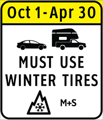
I was warned about the new BC winter tire requirement on Hwy-3.
10/14, Tuesday. Took a day off to hike (after seeing the wet forecast for the coming weekend).
Googled for a larch hike near Vancouver, and landed on Frosty Mountain. 22Km RT.
No one wanted to go with me for such a long hike :)
I was warned about the new BC winter tire requirement on Hwy-3.

 I drove out shortly after 7am, still chilly.
Road construction west of Abbostford created quite some delay. Otherwise at this hour, only westbound is congested.
I only reached Lightening Lake day-use parking lot at 10am. It's a large lot, about 10 cars.
COLD ~25°F. Frost on grass. The road was dry, not icy.
I drove out shortly after 7am, still chilly.
Road construction west of Abbostford created quite some delay. Otherwise at this hour, only westbound is congested.
I only reached Lightening Lake day-use parking lot at 10am. It's a large lot, about 10 cars.
COLD ~25°F. Frost on grass. The road was dry, not icy.

 Cross the footbridge to the north side of the lake.
A clear sign indicates a trail on to the treed slope. All in the shade. The ground was frozen hard and slippery.
I made a mistake of not bringing spikes, only had a pair of cleats because they are smaller.
They have only one strap each, which by nature of a foot, the strap slides towards to the front as you go up, and then slides off.
I readjusted the straps maybe 10 times. Eventually had to tie them to the shoe laces, still not the best.
Don't buy!
The trail starts zigzag up steadily but gently, all in the trees.
Occasionally you get a glimps of the Lightening Lakes chain through branches and the Hozameen Mountains beyond (striding across the US-Canadian border).
Cross the footbridge to the north side of the lake.
A clear sign indicates a trail on to the treed slope. All in the shade. The ground was frozen hard and slippery.
I made a mistake of not bringing spikes, only had a pair of cleats because they are smaller.
They have only one strap each, which by nature of a foot, the strap slides towards to the front as you go up, and then slides off.
I readjusted the straps maybe 10 times. Eventually had to tie them to the shoe laces, still not the best.
Don't buy!
The trail starts zigzag up steadily but gently, all in the trees.
Occasionally you get a glimps of the Lightening Lakes chain through branches and the Hozameen Mountains beyond (striding across the US-Canadian border).
 6km to Frosty Creek Campground. It's actually a side creek that flows to Frosty Creek.
Dark (very forested) and cold. There's a shelter. Wood platforms for tent.
Quite flat here.
6km to Frosty Creek Campground. It's actually a side creek that flows to Frosty Creek.
Dark (very forested) and cold. There's a shelter. Wood platforms for tent.
Quite flat here.

 It says that they are 2000 years old. It also warns you not to deviate from the trail.
Soon, the trail enters a flattish area full of larches. ~2100m.
Snow on the needles. Very pretty.
Here, there's a 9km sign.
It says that they are 2000 years old. It also warns you not to deviate from the trail.
Soon, the trail enters a flattish area full of larches. ~2100m.
Snow on the needles. Very pretty.
Here, there's a 9km sign.
 Then you see Frosty Mountains in front (south).
The mountains in other directions are far away.
Then you see Frosty Mountains in front (south).
The mountains in other directions are far away.
 To Windy Joe is a scramble. From there, it's easy to follow the ridge to Frosty East (end of trail, 11Km).
More serious scramble to Frosty West.
Right now, it's loose snow. Sketchy.
Half way up, I decided to turn around. Going down is worse.
To Windy Joe is a scramble. From there, it's easy to follow the ridge to Frosty East (end of trail, 11Km).
More serious scramble to Frosty West.
Right now, it's loose snow. Sketchy.
Half way up, I decided to turn around. Going down is worse.

 4:50pm, back at parking lot.
No more frost on the grass.
Drove to Manning Park Lodge before returning to Hwy 3.
A revisit to remind me of my last trip (20? years ago).
4:50pm, back at parking lot.
No more frost on the grass.
Drove to Manning Park Lodge before returning to Hwy 3.
A revisit to remind me of my last trip (20? years ago).


