I booked everything 6 months ahead, anticipating the crowd. The air fare was already inching up.
The 2 tickets, each leg is different.
I chose Texas, hoping for a sunny April day.
A month before my trip, Hertz called me to cancel my car reservation.
I scrambled to find another car. Took some effort, found one in the outskirt of north Austin for $535 w/o insurance (instead of $220 with Hertz including insurance).
4/4, Thursday. 0:00. I boarded United with a stopover in Houston, arrival ~8:30am.
Ate my breakfast while topping the battery on my phone. Took bus 20 into the town.
Bus fare is only $1.25. I got a day pass for $2.5.
Got off after the bus crossed Congress Ave bridge.


Walked along Colorado River. Very nice walk paths. Many joggers, kayaks on water, Geese on the lawn.
This nice building is 2 toilets. Huge.

I left the river walk onto Lamar Blvd.
First, visited the
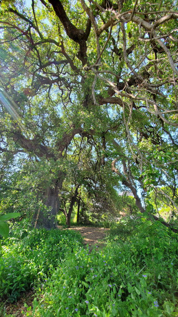
Treaty Oak.
A Texas live oak tree, the last surviving Council Oak, one of the grove of 14 trees that served as a sacred meeting place for Comanche and Tonkawa tribes before European colonization of the area. Estimated 500 years old.
It doesn't look impressive, but definitely alive.

Walked on 5th and 6th st to the town center.
6th is very lively, live with many bars and some small museum. One is called Museum of the Weird.
The best looking hotel is here:
Driskil (now owned by Hyatt).


I walked to the park south of
O'Henry Museum for a picnic lunch, while waiting for its openning at noon.
The small house has 2 volunteers eager to talk. The left is the mug shot of O'Henry when he was imprizsoned.
 O'Henry
 and his wife + daughter lived here for a few years. The piano in this photo was actually played by the wife.
The museum staff encouranges you to play too.
Next door is
Susanna Dickenson's residence with her 3rd husband, years after she came back from Alamo.
Here, the main exhibition is the description of the 12 survivors of Alamo.
Susanna is the only white woman.


Checked out
Jones Center (The Contemporary Austin's downtown branch), hoping to leave my luggage here while walking around the town.

But the museum has very little to see. 2 exhibitions, 5 minutes each is plentiful. So I'm obliged to take my bags when I left.
One is large paintings, all are people surround a table, lack of perspective, simple bright palete.
2nd floor is all long planks with misc decorations, not sure how they are grouped.
It has a covered roof, not very high, but good view.


Walking north to the capitol. On the way, visited
Saint Mary Cathedral, because the nice looking facade.
A small side door was open with a sign which I followed inside.
The stainless glass windows are new, but nice and colorful.

Visitor Center of the state capitol is in the capitol square, but in a separate building.
It has more to see than I had time for.
There is a documentary movie about the capitol ranch that I found interesting.
I had a reservation of a 2:30pm tour at the governor's mansion, where no backpacks or purses were allowed.
The front desk let me leave my luggage here (thank you).
I walked through the south border of the large green space surrounded the capitol building.
Not a lot of shade. Getting quite hot.

I was the last person of my group who arrived at the gate of the
governor's mansion, ~2:25pm.
The state government website publishes tour dates 1~2 month ahead.
I filled up a form, picked a date.
On 3/19, I was notified via email of an availability (the time slot of that day), and a request to submit my driver's license number (or passport number if you are a foreigner).
A week before the tour, I received a confirmation email (passed the background check) and a warning "no storage available".
Everyone heeded to the warning. No one brought any bags.
Security check (a lot of security guards) and X-ray first.


This house predated the capitol building by ~50 years.
Maybe the longest occupied governor's house.
We were shown the rooms downstairs. These are for public functions.

Once, a governor once hosted 3000 guests here for his daugter's wedding. Not sure how it would fit.
Nicely decorated with views to the garden.
Other than the history and anecadotes, we were told about the paintings, the memorabilias.
Towards the end of our 30 minutes, the wife of the current governor came out with "pancake" the dog to say hi to everyone.
She's gracious and amicable.


I walked back to the visitor center to fetch my luggage, and looked around the exhibit more, still rushed past many items.
Then onto the capitol building itself.
A lot of visitors here.
Many docents talking about this and that. My guide is an old blond lady with a Taxas droll.
Senate and House were not in session. We were allowed to wander around up to the 3rd floor.
The dome looks quite nice. Portraits of governer line the wall.
Whenever a new governer swears into the office, all the portraits have to be shifted by one spot.
~3:40pm I headed to the bus stop. It's a 45 minute ride + 20 minute walk to the Enterprise rental car office, where a car was waiting for me.
I called this morning just to reconfirm. It's $120 + tax, comes to about $530 for 4 days. Pricy!
I bought some salted duck eggs at a Chinese grocery store, visited a Mexican store. Didn't like either.

Did a 5 minute hike to the Pennybacker Bridge Overlook.
A pullover with capacity of ~10 cars right before the bridge, southbound only.
Almost no mergeL 60mph squeech to 0. Need to be careful.
Highly recommended. A lot of folks come and go. The path is a bit scrambly.
Good view of Colorado River and the bridge.


I had reserved a free ticket for the afternoon entry (it turns out unnecessary) to The Contemporary Austion's sculpture park at
Laguna Gloria.
This location opens until 9pm!
It took me awhile to find a parking spot.
I didn't expect it to be busy ~7pm.
All the streets were lined with cars.
I ended parking at Mayfield Park and Nature Preserve next door, but didn't visit it.


It turns out that today is the
unveiling reception of this giant tin bus called
Mariposa Relampago.
I was given a brochure and 2 drink tickets.
After walking around the property, I found the bus at the end of a walk.
You are free to board the bus, sit on it, touch the giant utensils.
At some point, there was a long sound ceremony where 3 artists climbed on board played the drums.
Right next to it is a table handing out drinks and a pop-up takeout food canopy.
I had a taquila cocktail called sunshine. I like the color. Too bad, they don't have beer.
Thankfully, now the sun was gone, it's not so hot any more.
I had a cidar next. At least it's chilled.
Before driving to San Antonio for the night, I bought some food and beer from Trader Joe's.
Eating as I drove, to keep myself awake.
San Antonio is only 70 min south.
Checked into the hotel ~9:30pm, unloaded food into the fridge. Washed.
Headed to the airport ~midnight to pick up my partner.
4/5, Friday. Sunny, very warm. Breakfast at hotel.


Walked out to downtown along San Antonio River, north bound.
A couple of cute southern houses with large verandars.
Very pleasant.
Along the Passeo de Rio (a loop), many restaurants decked out in flowers and tables taking over half of the walkway.
Bridges crossing the river often, colorful barges filled with people with guide yelling into speakers.
Quite pretty.
We made a snack stop by the river, and another lunch stop at a random restaurant.
It was getting warm.

 Alamo
Alamo is a must-see in San Antonio, a crucial relic in the Texas history.
Now the large Alamo Plaza is under reconstruction, making some new "experience" for future visitors.
There's actually not much left to see.
The facade of
mission Valero church is almost intact. The long barack. All the rest is fabrication.
A lot of tourists. A queue to get into the church. Another queue to get the (free) ticket to go into the church.
All under the sun, no shade.
They try to sell you package of different combo of virtual experience. Not sure why anyone would bother.
Very crowded.
The church was never completed, the mission was abandonned ~1800.
Military occupancy later. The claim to fame is the
Battle of Alamo of 1836 during the Texas Revolution.
When Mexican troop killed nearly everyone, it ignited the revenge, which led to the victory of
Battle of San Jacinto a little over a month later. Thus the Republic of Texas was born.

Before escaping the heat to the AC-controled hotel room, we checked out the cathedral (looks a bit new, nice facade) and the county court house (a striking red building).
It has a decent exhibition of the local history on the ground floor.
Took a short siesta.
~4:20pm, we headed out again in the heat, driving to the Hill Country for
bluebonnet - Texas' state flower. Slightly cooler too.
As we left the city, started to see patches of flowers along the highway (in the median, on the banks, but nothing in the rest areas).


First stop, the Stonehenge II.
I guess there are many Stonehenge #2s.
I didn't like this one. All stones look the same. I like the 2 giant heads.
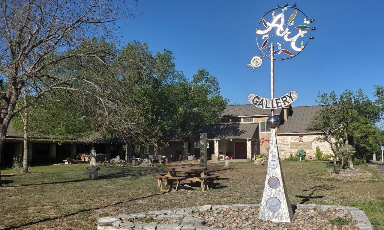
Next door is the Hill Country Visual Arts Center.
It was closed, with many signage and posters for parking (preparing for Monday).


Stopped by Kerrville. Nice cute downtown. Some old handsome buildings like this
Schreiner Mansion (of course closed at this late hour).
I especially like this large overlook of Guadalupe River.
Again, saw parking signage and posters for Monday.


Willow City Loop off Hwy 16 north of Fredericksburg is what my research said as a destination for Texas Bluenette.
Already saw plenty along Hwy 16.

Road 1323 towards Willow City (no city really). Private ranches.
Curvy road. The Willow City Loop actually climbs up some elevation, offers view of the neighboring field at times. A couple of small creeks. Very pastrol.
At the end of the loop, due north of Hwy 16, saw this patch of white poppies. A lot of them.
Beautiful against the setting sun.
Did see a few other flower chasers (less than 10), taking selfies while trampling the flowers!
Back to hotel quite late.
4/6, Saturday. Breakfast in the hotel. Going to the ocean today, hoping to see some birds.


First stop is Choke Canyon State Park ($5/pp). Saw maybe an ibis.
Two different entrances to two corners of the large reservoir.
Quite a few people fishing. Picnic tables all have roofs. Many fish cleaning stations.


Next, Lake Corpus Christi State Park (same ticket works). Another reservoir.
Again, quite a few people fishing here. More campers. Being a Saturday, it was busier.
The lady at the entrance mentioned one trail for bird watching.
We went, saw a group of school kids, no birds.
However I found this CCC built pavilion, named
Castle, interesting.
Made a mistake of visiting Pollywog Pond Bird & Wildlife Sanctuary. Very buggy.
Swampy. Looks like waste-water treatment ponds.
Lots of small birds chirping, but couldn't see any!

Driving over the water to Padre Island is scenic. 2 very long bridge, or causeway.
We stopped briefly at Red Dot Pier right by the highway, in the middle of the water.
Many fishermen. Windy.

Drove south towards
Padre Island National Seashore.
It's a very long stretch of sand bar (endless sand dunes).
So wide that you cannot see water when driving on the road.
Picked a side road, and drove to the beach.
The water isn't cold, but still, I didn't dare to swim.
Not many people, they drive their car onto the beach.

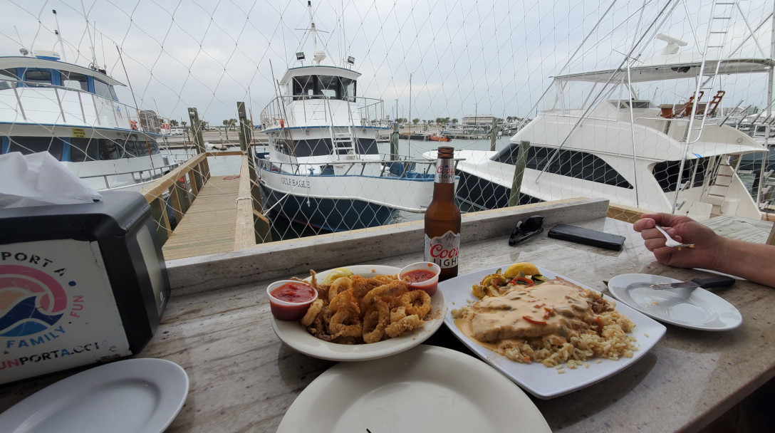
After checking into a hotel at Port Aransas, we went for dinner at the Fins, recommended by the hotel front desk. It's overpriced. Had their snapper, a bit over cooked.
The seating area is covered with net. Laughing gulls are flying about and watching you (or rather your food).

After dinner, walked to Roberts Point Park next door.
A lot of folks were fishing.
This guy caught a big Black Drum, proudly posing for photos.

People here drive golf carts around instead of cars.
Not a bad sunset.
Wet weather was coming.
4/7, Sunday. A few drops of rain in the morning. Still warm.
Breakfast in the hotel.
Took the short ferry (free) back to the mainland. They run continuously. Each boat can carry ~10 regular cars.
Drove back to San Antonio to checkout the
missions that I forgot yesterday.


First one is
Mission Espada.
First mission in Texas, transferred here in 1731. The building was finished in 1756.
We missed the aquaduct north of the mission, dated to 1745.
Lots of potted plants in the corridor. Very pleasant.

Next is
Mission San Juan. Mid 1700s.
I didn't like the white plastered wall.
3rd is
Mission San Jose, the most crowded and the largest of the 5 along San Antonio River.
Large parking lot(s). A separate museum and gift shop.


~mid 1700s. More elaborate church, surrounded by walls on all 4 sides. A granery.
As with all other churches in these missions, the inside is plain.

Last (most closer to San Antonio) is
Mission Concepcion.
Also moved here from eastern Texas.
Thick wall, unrestored, yet stil standing.
There's a remnant of the quarry, where the stones for the church came from.
The walls are gone.
All 5 missions, including Alamo, are worth visiting while you are in the area.
But none of these churches can compare with those I saw in Mexico.
Maybe not enough population to sustain all these churches in such close proximity.
Now, going back to Austin (where we'll be watching the solar eclipse).
Drove to UT Austin to see the
Ransom Center.
It's Sunday. Free parking = no parking. Took me awhile to find a spot.
The lady at the reception asked "Are you one of those eclipse people who's wandering around"?

The main reason to come here to see the 500 year old
Gutenberg bible, one of the only 20 in the world.
I'm surprised to see it in such good condition.
Nicely displayed. They'll turn the page a few times a year.

Another prized posession here, which I wasn't awared of is this
Niépce Heliograph (1827), earliest know photograph.
However, it's almost impossible to see what's on it. So vague. Vague title too: viewpoint.
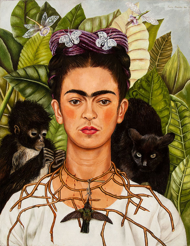
There's a
Self-Portrait with Thorn Necklace and Hummingbird by Frida Kahlo. Not very big.


A temporary exhibition of
Elizabeth Olds: paintings, silkscreen, lithography.
The brushstrokes are coarse. Some are satiric, like this one titled
Picasso Study Club and this
Sister's Union Demands Shorter Hours for Prayer.
Another temporary exhibition that we spent most of our time is
The Clarkson Stanfield Album:
many early photographs by the partnership of
David Octavius Hill and
Robert Adamson.
The subjects are often everyday life.
There is a long poster on
Calotype, an early exposure method.
However, it doesn't make me understand it and its advantage over daguerreotype.

Next, checked out a public art installation called
The Color Inside in the student activity center.
Need to reserve tickets if visit during sunset time.

The campus is very pretty along the flower parterre (University Ave) and the Littlefield Fountain.
Quite a few students in graduation gowns. I asked one, was told that they were just taking photos, not graduation yet.

Drove out of the school to visit the troll Malin in Pease Park.
Parked on Park Way, and walk down to Shoal Creek. It's just some green space, without the troll, it's not interesting.
Now it's time to settle down for a spot for the evening
bat show near Congress Ave Bridge. The trick is finding a parking spot.
Maybe because it's a Sunday free parking, every street near Congress Ave was full of cars.
Parked on Lee Barton Dr between a condo called "Bridges On the Park" and a small golf course called "Butler Pitch and Putt".


Walked along Colorado River.
Very pleasant with good view of Austin downtown on the other side of the water.
There are also these root stumps, like alone San Antonia River.

We walked up a small hill SE of the bridge, marked as Bat Viewing Site on Google Map.
A lot of people, and more and more were arriving.
Sunset around 8pm, but no sign of bats until almost 8:30.
They came out in waves.
Those boat tours shine red lights under the bridge from time to time.
The best time to see them is supposed to be August when baby bats were emerging (so double the population).
All what roosting here are female. Don't know why.
Checked into the hotel quite late.
4/8, Monday.
Total solar eclipse.
There are many "viewing parties" all around the town.
Not sure which one to go to, where to park, plus not running into traffic jam when we leave for the airport (which is just right outside of the totality zone).
I decided to go to
Zilker Botanic Garden.
After yesterday's difficulty to finding parking spot,
we arrived at the garden right after they openned (10am).
Very happy to snatch a parking spot. It turns out that throughout the morning, there were parking available.
The eclipse was supposed to be around 1:37pm. That's a lot of time to wait.


The park is very small.
Didn't take long to walk all around.
There's a small Japanese garden with Koi fish.
A so-called prehistoric garden with concrete dinosaur and a butterfly garden with giant plastic butterfly chairs.
The rose garden and the main lawn is very nice.
Quite a few different kinds of flowers blooming, but not all have tags, so I had to ask the employees in the visitor center with my bad photos.
My favorite is this this
Asiatic Day Lily, which is everywhere in this garden.

We eventually settled at the flat lawn next to the visitor center.
They gave out "eclipse glasses" which is so dark, that you can use it to see full sun at noon.
They also sell better eclipse glasses, which is more usable.

Clouds moved in, covered the sun from time to time.
Everytime the sun shone out of the clouds, people cheered.
Slowly the moon moved in, and the sun was like a new moon.

Too bad, at 1:37pm, the sun was covered by the clouds.
So, couldn't see the corona, or the solar wind, or the 360° sunset.
Definately, it cooled down (not as obvious as if it were no cloud cover), and all the birds shut up.
Soon, birds started chirping again, and we got up to leave.
It started to drizzle as we drove to the airport.
I filled the gas right outside of the airport. But Enterprise charged me 5.5 gallons of gas.
They said that the Bluetooth in the gas tank showed only 4.5 gallon, even though I just put 6 gallon into the car!
Oh, well.
A sour note of an otherwise good trip.
Back in Seattle in rain, of course.
 The town of Long Beach was bustling. The kite festival is a week long event.
Many teams were praticing their routines, carefully choreographed.
4 quadrons on the sand were fenced off for competition, demo and practice.
We, the tourists, walk along the edges. The organizer was smart enough to leave a gap between each quardrons.
Many more kites stay flying in the sky. We saw a few whales, one half guy only waist down, a large octopus, many butterflies and birds (including a large crane).
All very colorful.
The air is fresh, breezy and chill (not sure if it is even 70°F).
The town of Long Beach was bustling. The kite festival is a week long event.
Many teams were praticing their routines, carefully choreographed.
4 quadrons on the sand were fenced off for competition, demo and practice.
We, the tourists, walk along the edges. The organizer was smart enough to leave a gap between each quardrons.
Many more kites stay flying in the sky. We saw a few whales, one half guy only waist down, a large octopus, many butterflies and birds (including a large crane).
All very colorful.
The air is fresh, breezy and chill (not sure if it is even 70°F).
 Then it's the demonstation. All the groups are fabulous.
I especially love those large groups, this one with 12 people.
I don't know how they avoid entangling their 12 kites.
Then it's the demonstation. All the groups are fabulous.
I especially love those large groups, this one with 12 people.
I don't know how they avoid entangling their 12 kites.

 The most impressive is this guy, one person flying 3 purple kites with long tails, all syncronized.
Last time, we saw a deaf guy flew 3 black kites (no tails). It was very impressive.
The most impressive group os TKL of 6 people. They did 2 demos. Both incredible. Won many applauses.
Other wonderful groups that I got the names are: Quantum (4 kites), Sky Sisters (4 kites).
This is really an exceptional show.
The most impressive is this guy, one person flying 3 purple kites with long tails, all syncronized.
Last time, we saw a deaf guy flew 3 black kites (no tails). It was very impressive.
The most impressive group os TKL of 6 people. They did 2 demos. Both incredible. Won many applauses.
Other wonderful groups that I got the names are: Quantum (4 kites), Sky Sisters (4 kites).
This is really an exceptional show.
 At ~5pm, we left for Cape Disappointment state park.
First, we parked at the boat launch lot and tried fishing off the pier.
There's a fish cleaning sink and water hose. A lot of fish bones on the rocks below, attract a lot of sea birds.
This family in the photo came to clean their catch: a large salmon.
The dad told me where people are catching fish: over the jetty.
So we headed there next.
At ~5pm, we left for Cape Disappointment state park.
First, we parked at the boat launch lot and tried fishing off the pier.
There's a fish cleaning sink and water hose. A lot of fish bones on the rocks below, attract a lot of sea birds.
This family in the photo came to clean their catch: a large salmon.
The dad told me where people are catching fish: over the jetty.
So we headed there next.
 So many people were trying to fish here. They all had long thick rods.
The jetty is long, what this photo showed is only a small part.
It requires some scramble to get to the water side.
We tried our luck with fish and crab. Seems no one is catching anything now.
So many people were trying to fish here. They all had long thick rods.
The jetty is long, what this photo showed is only a small part.
It requires some scramble to get to the water side.
We tried our luck with fish and crab. Seems no one is catching anything now.

 This is a good place to wait for sunset too. Good view.
Groups of pelicans flew west from time to time, no idea from where they emerged.
View of Oregon coastal mountains to the south.
Jellyfish in the water.
This is a good place to wait for sunset too. Good view.
Groups of pelicans flew west from time to time, no idea from where they emerged.
View of Oregon coastal mountains to the south.
Jellyfish in the water.
 Headed back after sunset.
Willapa National Wildlife Refuge, which was just mud and marsh, now looked very pretty in the dying sunlight.
A very long drive home.
Headed back after sunset.
Willapa National Wildlife Refuge, which was just mud and marsh, now looked very pretty in the dying sunlight.
A very long drive home.