Monday, May 31, 2021

2021.5.31. Ballard Lock

5/31, Monday, Memorial Day. Sunny. Went to Ballard Lock. Last spring when I came here, the garden was locked (due to COVID-19). Flowers were blooming nicely. There were many different colored columbines: purple, pink, white. Freshly mowed lawn to sit on both side of the canal. The bathroom north of the lock is open (not the visitor center: opens on Fri-Sun?). Quite a few people, and a lot of boats.

Many herons roost on the trees just north of the lock.

Sunday, May 30, 2021

2021.5.29-30. Blewett Pass - Icicle Ridge

Memorial weekend. Warm. One of the objectives is looking for tweedy.

5/29, Saturday. 1st stop: Red Top Lookout. ~7 miles on wide but bumpy forest road. The parking lot is not on Google map, but it was clearly signed. WTA's direction works perfectly. Quite busy (at least 20 cars in 2 parking lots), lots of kids.

The decommissioned lookout is only a half mile walk. But good walking shoes are needed. Loose rocks. On the way (even by the road), a lot of spring beauty. Some glacier lily, trillium, silver crown. I found a few yellow bells, a rare Washington Twinwood.

The lookout has a sign with a short history. A narrow veranda wraps around. The door locked, shutters down. View is great all around, especially the Stuart Range to the west. Could see Adams and Rainier today.

Continued onwards north, a guy was setting up a large ham radio antenna. Down the ridge on the trail, to the junction with Teanaway Ridge trail. Continue north to an open field, where a couple of groups of family were digging the dirt. There's supposed to be thunder eggs and agate here. I don't really know what to look for, quickly abandoned rock flipping. Besides, I like the slope covered by grass and flowers, instead of the scar. Back to the junction, and followed Teanaway Ridge trail back to the parking lot. Had lunch there.

Tweedy2nd stop is Tronsen Meadow. Very bad road (1.6 mile). We saw the rare Tweedy here last May. Sure enough, they were blooming. Found them around 4500' and again 5000'. Such a beautiful flower. I walked up to the road junction (FR-9712). Saw rockcress, shooting star, balsamroot. Encountered 2 people on my way up, and a couple on my way down. Probably should continue to Naneum Creek for more flowers.

tentDrove to Icicle Creek for the night. My planned camping spot was taken. Found a smaller site. Another objective of this weekend is trying out my newly acquired $25 (+tax) tent. No vestible, too short, probably leaky if rained. Otherwise, quite usable for car camping. 3.5lb. Didn't bother to put up the rain cover.

5/30, Sunday. Late start. Hiked up Fourth July Creek to Icicle Ridge lookout. Crossed the creek twice earlier on. lupineSaw one tweedy at ~5000', yellow current and mariposa lily at lower elevation. Tons of lupine, then penstemon, jacob's ladder. My buddy was still suffering from headache caused by last weekend's fall, so he turned around. It was hot and dry on the slope. I was sweating profusely. Made multiple snack/water breaks. At higher elevation, burnt trees. The higher the better view. Thankfully, the clouds moved in when I was close to the ridge (already 4000' above the road).

The ridge was still covered in snow. Fairly flat here. I cut the zigzag and headed straight to the lookout, bypassed a couple ahead of me. The last rock requires pulling myself up by the iron rods. See my last June's photo. A bit windy on the top, so I got down to have lunch behind some rocks. The 360° view is exellent. Despite of the clouds, better view this time. I could see Glacier Peak, and many other peaks to the north, as well as the Enchantments.

Down the same way, nothing to report. I headed down at 2:30, was pretty fast, and got to the TH at 4:34. Waited to be picked up. Drove back home after a gas stop. Smooth sailing. Probably more traffic on Monday.

Wednesday, May 26, 2021

2021.5.26. Dog Mountain

5/26, Wednesday. Cloudy. I took a day off to visit my favorite flower destination in May: Dog Mountain. Now, it's a long drive (3.5-4 hours from Seattle). On the way, detoured to Mima Mound. Too late: only saw 2 camas.

I arrived at the trailhead ~5:30pm. The parking lot was ~60% full. Took Augspurger Mountain trail up. Less crowdy. Met maybe 5-6 hikers. Forgot my water bottle in the car :( Saw a lot of blue-dick at low elevation, a bunch of clarkia on rocks. Lots of rocks (larger size than gravel) were spread over the trail. I actually stepped on one rock wrong and tumbled down the slope at one spot. At the turn to Dog, finally on the meadow stretch. I was about 1 week too late for flowers, most balsamroot was withering. However, still beautiful.

I found a large rock to sit and had dinner, waiting for the sun to set. A bit of wind, got somewhat chilly. A few tripods here and there. Clouds were too widespread. I headed out before the sun dipped down the horizon. Back at the TH ~9:30pm. Driving home is a bore. Dozing off, and had to pull into two rest areas to refresh. Filled gas. Got home safely.

Sunday, May 23, 2021

2021.5.22-23 Silver Star Mountain

5/22, Saturday. Diablo LakeDecided to try Silver Star Mountain upon O's suggestion a couple of weeks ago. O and V planned for a one-day assault. Too long a drive (3.5 hours one way) for a day hike, IMHO. I opted to an overnight outing. Washington PassLeft Seattle on a relaxed morning, making a stop at Diablo Lake lookout and had a picnic lunch here in shade. Made another stop at Washington Pass for photos.

I was surprised to see so many cars (~20) at the unofficial TH (not marked on Caltopo). There's even a privy. We started hiking close to 12:30pm. We found the boot track right next to Silver Star Creek's east (left) bank. The "trail" is overgrown and obstructed by down trees, and it goes up quickly. Saw quite some glacier lilies, and one fairy slipper early on. Soon we hit snow.

About 1.5 hour from the TH, we reached an open slope with great view of our destination and Visiliki Ridge, before going into the woods again. Soon, the slope eases to flat swamps. Punching holes right into water at times. Multiple tracks going around soggy grounds and fallen logs in different directions. Once you emerge from the trees again, you are facing the head wall of Silver Star Creek basin. It's better to cross the basin to its right side (west), and up towards Burgundy Col. As it happens, we saw a group of girls coming down the left side, following Silver Star Creek, so we went up the left side. Quite steep, so I took ice axe out.

We reached the flat area, and pitched the tent in the middle of some boulders. ~6300'. Good view all around. I dug snow trenches at the tent doors, for foot-rest. Dug a smaller hole for cooking. It drizzled a bit at night.

5/23, Sunday. Clear blue sky. Didn't wake up early enough for sunrise. Still, early morning has good light. After a lazy morning (read my library book) and breakfast, we headed up towards Silver Star Col, in crampons, ice axe and helmet. Should have brought along micro-spikes (better for glissading).

All the way to the col is straightforward. Steep at times, but wide and soft snow, safe enough. I even took a minor side track to go along the left (east) ridge for a bit to see the Varden Creek basin: Varden Spire, Silver Moon, .... Quite a few people today, more skiers than hikers (see photo to the right).

The view at the col is absolutely amazing. Countless snowy peaks. Had a long break here, ate a sandwich, chatted with a stranger, who told us a scrambling route to Lake Syvester and Grindstone Mt.

From here to Silver Star Mountain is exposed, steep, rocks with narrow snow strips. Made to below this rock gap, ~10-20' below the summit. Two rope parties, one having trouble getting the rope off, another tying his. I tried to squeeze in the gap, couldn't find a good hand hold, so gave up. Still good to get here. The view at this perch is unbelievable.

Back at the col for another break before going down to the camp. I glissaded a couple of times. Having crampons on is not a good idea. Packed and hiked out. We should have followed most hikers. Instead, we followed our own ascent route to go down. A bit scatchy. I back-climbed, relying on ice-axe without trouble, just very slow. My hiking partner took into the trees, and managed to tumble down to a lower tree, and hit his head, slit his pants. When we reached the trailhead, it was ~6:30pm. Rained on the drive home.

I'm already thinking of coming back here at larch time.

Sunday, May 16, 2021

2021.5.15-16 Thunder Mountain Lake - snow camping

5/15, Saturday. 8 of us met at P&R at 7am. 3 cars. One lady (T) rode in one car, and her pack and boots in another. I was in a Jeep with B, only 2 seats, along the way listening to his spotify (AI recommendation influenced by his 10 year-old daughter). One story is fascinating: a woman revived after 6 hours of cardiac arrest. After a long stop at a Starbucks in Monroe to use the toilet and get caffinated, we arrived at Surprise Creek TH ~9am (had to wait for a train to pass). Our objective this weekend is Thunder Mountain Lakes (Caltopo map). Our hike leader, M, let us weigh our packs. Mine was at 27.5 lb, the lightest. Won't get lighter, because we have to carry our poop out. B's is ~20 lb heavier. He brought a couple of cans of beer, and all possible gear (snowshoes, crampons, helmet, ice-axe). Half of the team wore their helmets. I didn't bring crampons or helmet. Another lady brought a bottle of sparkling wine!

I was ready by 9:10, the rest of the group was slow strapping their snowshoes and sleeping pad. We entered the Alpine Lakes Wilderness boundary a few minutes in. With all the shade, we hit snow patches pretty soon. The trail is well engineered, with stairs and boardwalks. However, now snow covered most of the boardwalk. Surprise Creek is running fast, multiple small side creeks, and whenever they cross the trail, they cut a ditch in the snow, so you could actually see the trail. In less an hour, we needed GPS to "follow" the trail. S. charged ahead, leading the wrong direction multiple times, because he prefers compass and printed map. K, B, and I were checking GPS map our phones constantly. Two slower ladies M & M were so slow, that after a couople of waits, at the bridge crossing (1 mile in), M gave them a walkie-talkie and a beacon. The rest 6 of us headed onward without them.

Surprise Lake1 mile later, it opened up a bit, and you could see the steep hills on both sides. I took my umbrella out. However, the elevation picked up. It gets steep before easing out into the lake basin. I need both hands, so stashed away my umbrella. We didn't reach Surprise Lake until after 1pm, and I was starving. Had lunch in the shade looking out to the lake, already thawing on the edges. Very pretty. The walkie-talkie buzzed. M. Walked back to get better reception. The 2 slower ladies were giving up.

From the lake up, the slope is quite steep. PCT goes through here with zigzags. However, now all under the snow, no hint of any trail. We just picked our way up, following GPS map. B called for rest a couple of times, he was almost panicking, even though he was on crampons (an over kill, imho). M didn't wear any traction device, just boots. K and I were ahead making steps. We reached Trap Pass ~4:20pm, about 1300' up from the lake. Yes, slow. You can see Trap Lake below. There's supposed to be a trail going down. Of course, we couldn't see. B claimed he would camp here, didn't wish to continue. There isn't enough space, maybe for 1 tent. After some rest, he relunctantly followed the rest.

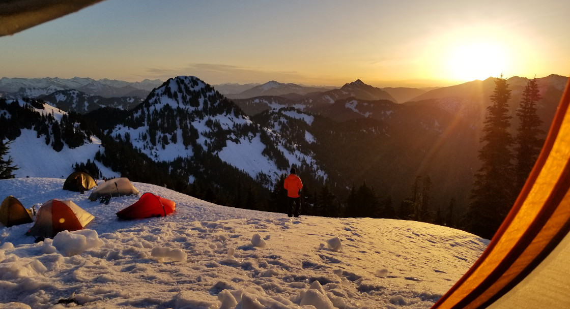
Instead of keeping up on the ridge (pretty narrow with rocks and trees), we took to the right (west), dropping down a bit before going up. S was charging ahead. B needed another rest. I kept closer to the ridge, to follow my map. I met up with the group before the ascent to the ridge below Slippery Slab. ~6100'. Already after 5pm, we set up our tents here. View is excellent west, north and east. The south is blocked by Slippery Slab.

After pitching my tent, a bit away from the others: higher, and half sheltered by trees. I tried to dig a trench, but got bored 10 minutes in, only thigh high, shoulder wide. I'm pretty happy with my new snow shovel. I also dug a small ditch by my tent door to rest my feet, and cooking gear. We ate dinner watching the sun to set slowly. Cresent moon to the west. The sky didn't darken until after 9pm.

5/16, Sunday. Warm. 80°F in the city. Woke up ~3am to use the trees. Not too cold. There was still ice in my water bottle (in the tent). The stars were brilliant. Moon was gone. Milky Way was up. Took awhile to fall back to sleep. Sun woke me up next. Missed the proper sun rise. Took a couple of photos and went back to sleep.

Got up around 7, laid my sleeping bag on the trees. Then, cooked breakfast, packed the sleeping bag and pad, waiting for the snow to soften. I laid my water bottle in the sun to melt, and it rolled down the ridge. At 8am, I checked with M that I'd be back at 9:30, so I could be ready for his departure time: 10am. With my ice axe and an empty pack, I headed down the ridge. Picked up my water bottle first, then continued south towards Thunder Mountain. This photo is looking back at the camp (marked in red).

The terrain is gentle, rolling snow fields. I should have worn snowshoes. View to the east, below the jaggard ridge. I didn't go down to the lake for the sake of time. Walked on to the knoll of 6600', just below Nimbus Mt. for a 360° view. This is the view to the south: upper Thunder Mountain Lake just below me, already thawed on the edge, lower Thunder Mountain Lake in the shade. Countless snowy peaks.

At 9, I headed back. Arrive at the camp ~9:35, and packed up at 10. Not the last person to be ready. Going down a steep slope is always worse. I slipped a few times, but with soft snow and plenty of trees, you don't slide far. Saw ~10 people once we were below Surprise Lake. Back to the car ~3pm. As always, traffic jam on Hwy 2. 40+ minute delay. B is an exellent driver, knows the back roads. We were back ~15 minute ahead of the other car. Waited in the parking lot, chatting with T's BF, who came to fetch her. Her backpack was in B's car. One of the slow ladies also came to the P&R to return M's walkie talkie and beacon, so we got to hear about her trip. All is well.

Sunday, May 09, 2021

2021.5.9. Another day for flowers in central WA

5/9, Sunday. Partly sunny. I was picked up ~8:30am. We headed to Whiskey Dick Ridge first. Followed the direction on WTA, and drove in ~half a mile with big ditches to a large flat spot with 5-6 other cars. One car parked at the entrance by Vantage Rd. Walked along the road for another ~half a mile, dotted with narrowleaf goldenweed and lupine. Met a group of elderly birders with large scopes. Some hardened muddy footprints of elk. Bitterbush was blooming profusly (otherwise, they look like sagebrush), giving off a faint fragrance. A favorite of deer/elk.

hutVery dry and open. Sagebush stepp. We saw this hut from afar from the dirt road, and headed down there. Odd, all it sheltered is a rusty stove. There might be seasonal creek nearby in winter, kinda of in a shallow ditch. Just north of this is a rocky section. Lots of whitetop on the way. We walked gingerly, for fear of disturbing a snake. Found my first bitterroot this year. What a delicate flower.

lewisiacactusOne objective to hike here is Simpson's hedgehog cactus. We only found 2 in bloom. Hot pink. Elevation here is barely 3000', a little low for that cactus. There are more, but not very abundant. The top of the ridge is very nice. View of the wind turbines to the west (a little bit of Teanaway mountains too), Columbia River to the east. More flowers, especially cushion buckwheat in a variety of colors. Both hooker and carey (or arrowleaf) balsamroot were on their last leg. Lupine too was seeding. Gairdner pensemon provided the most purple right now. It's named after Meredith Gairdner. Other flowers in bloom were: threadleaf phacelia, larkspur, yarrow, Thompson's paintbrush, bighead clover, fernleaf and nine leaf lomatium, some pink fleabane, large-flowered brodiaea, Hooker's onion, showy phlox, tidytips. A lot of sheep droppings, but didn't see any animal. Thank god, didn't see any tick or snake either.

On our way down, met a 3 generation family with a dog. Didn't meet anyone else during our time in the area: I like it. At the trailhead, only our car. They probably parked by Wild Horse Wind Farm. They host public tours before COVID.

Our second hike is short and sweet. The baldy summit is like a garden right now: covered with thyme buckwheat of different colors (a sour smell). Lots of bitterroot here too. I decided not to name the trail, so not to draw more people. It's already quite busy. The ridge is also flanked by flowers, especially showy phlox. The lupine here is more pink than purple. We sat here for a long time. Clouds moved in, and a few rain drops fell.

Gave up the 3rd hike, we went home early with this buckwheat image eched in our mind. A grand finish.

Sunday, May 02, 2021

2021.5.2. Spring flowers in Wenatchee area

5/2, Sunday. Time for basalmroot. Headed over to Wenatchee. First hike is Sage Hill. We took the Day Drive TH. A very small parking lot (~6 cars). The neighborhood has many "no parking" signs, many cars parked farther down the road, and we did too.

A busy trail. Tons of lomatium nudicaule on the lower slopes where the trail is. Balsamroot were starting to wither. No trail going up. We followed a gulch and headed to the trees on the top (the red circle). The higher we were, not only good view of Columbia River and the city of Wenatchee, fresher balsamroot, more lupine, and then showy phlox, some larkspur, fiddleneck, salsify, phacelia. No paintbrush, not much sage brush. A home in the middle of all the splendar. Yes, there's a fence to the south of us.

Once we reached the trees (circled in red) in the first photo, there is a trail going further west. After a break in the shade, we followed the trail, down a bit into a flower filled shallow valley, before going up again. More trees here. After cresting the ridge (circled in red in the photo on the left), mountain view pop up: Enchantments, Glacier Peak ... Took another break in the shade admiring the view, saw hikers coming up from west. Consulting the map, there are more trails from the north (Horse Lake Preserve) and west (not sure where).

On the way back, saw a couple and 2 dogs in the trees in the first photo. We went down straight, saw boot track from time to time.


On the drive back, we hiked Sauer Mountain. Another busy trail. Much nicer than my last trip here (automn). Balsamroot and silvercrown graced all slopes, among pondarosa trees. Somewhat steep zigzag at the beginning and it was hot. Should come here later (we started ~4pm), or in the morning. Very gentle ridge walk in the trees in the middle. Saw a family of 4: 2 toddlers, wife in tight fitting dress, husband carried the only bottle of water for the family in his hand, only 0.5L. I was surprised to see that they made to the top on this almost-hot afternoon.

Before the last (steep) ascent, you cross this road. Need hands to get up here onto the trail. There were quite some people at the summit, where the sign was. We continued a bit on the trail north, for a view to the NW, and away from the crowd.

On the way down, I found a wild peony!