Labor Day weekend, 2 nights of camping by Boulder Shelter, day hiked from there. The temperature was in the 80°Fs, not pleasant.
 8/31
8/31, Saturday. Up at 6am, caught the 7:10am ferry.
Already quite a few boats out. Peaceful.
Started hiking ~9:30am, from Upper Dungeness River TH.


1 mile in, turn left to cross the first log bridge. (Continue straight would be going to Royal Lake, signed.)
Many people camped here. I've camped here twice before.
35 minutes later, cross the 2nd log bridge.
Both are quite substantial, with railing and ramps.
The trail is mostly flat, following Dungeness River. Nice sound and nice soft trail (not dusty). Shade.

15 minutes after the 2nd bridge, we reached Camp Hardy.
From now on, we started to gain elevation. Crossed a few creeks.
Chatted with 2 people (father and son?) who were leaving and had big packs.
They camped at Home Lake. I was informed that mosquito was not an issue at all. They had never heard of Charlia Lakes. Nor had I just a week ago.
Settled near Boulder Shelter: ~6 miles, 2400' from TH.
Already people camping around the shelter and 2 tents out in the messy-looking meadow.
This is not surprising, being at the junction of multiple trails.
My partner found a good site close to the creek and trail, but mostly out of view.
Pitched the tent, ate.
It was getting warm.

~1:30pm, we headed out to
Charlia Lakes in increasing heat.
Good trail, just not signed, not marked on official maps.
At the junction, you'd see a sign for "Home Lake". Take the trail to the left, uphill.
There's a nice camp next to a pond, maybe earlier in the season. It looks too small for good water.
It's about 600' gain from Boulder Shelter. On the way, there's a good huckleberry patch.
Took a break in the shade. From here and up, shade is hard to come by, getting above treeline.
Umbrella is handy.


Saw many harebell on the sun drenched slopes.
Zigzag towards the saddle, all the way, pretty good track. Another ~700' up from the pond.


The saddle itself offers no view of the Charlia Lakes, it's too flat and wide.
You can see the Puget Sound.
Walk a bit lower east, or higher to the hills on either side, then you can see the Upper Charlia Lake.

I walked up towards Cloudy Peak to my right. Hit a broad saddle, where I can see both Charlia Lakes and a pond.
Better view of Puget Sound and the surrounding peaks.
Took a break hiding in the few clumps of pines, then going back to camp.
Saw 2 groups of 2 going down to Charlia Lakes to camp.
Boulder Shelter to the saddle of Charlia Lakes is ~1.4 miles, 1300'.
Brilliant stars.
9/1, Sunday.
It's another warm day. Needed to avoid afternoon heat.
We headed out towards
Constance Pass ~7:30am.


Sun just rose, nice color of the hills opposite of the valley.
Home Lake trail is mostly flat. After the initial uphill, it actually goes down for almost 500'.
At the boulder area, I paid attention to tracks going up towards Warrior Peaks, but found nothing obvious.
Afterwards, cross the valley floor over boulders into trees again.

Gaining ~800' to Home Lake. 9:20am.
It's a nice looking lake, but rather small. Some leftover flowers, especially yarrow and fireweed.
Some nice camping sites. Saw 3 guys in 2 spots.
My partner walked to the north end where fireweed was most abundant, and informed me that the water looks dirty with a greesy film on top.
Had a snack break next to the first campsite, before going up towards Constance Pass.

The trail going up to Constance Pass zigzags up a flowery slope.
A running creek feeds the lake below. Lots of fireweed by the creek.
This photo was taken on the way back when the lake was entirely lit in the sun.

About 0.5 mile 500' up from Home Lake.
The pass is low (5600'), offers view to Puget Sound and many peaks to the south.
But better views await higher.

Follow the trail west (right) on the ridge (now Constance Pass trail) for 3/4 miles, gaining 700'.
Before the trail goes down, detour right CX a short distance to a gentle rocky summit. ~6550'.


Excellent view from here, and all along the ridge.
Too bad, it was a bit hazy this weekend, so the view to Puget Sound wasn't clear.
Also unable to sit here: a nest of flying ants occupied the highest rock.
We picked some short pines a bit lower, to hide in the shade and savour the expansive view and the silence.
Didn't meet anyone between Home Lake and here.
Only on the way down, met ~5 coming up this way.
This camp site looks enticing.
2100' and 4.5 miles from camp. Going back to Boulder Shelter is another 480' gain.

I also continued Constance Pass Trail towards Sunnybrook Meadow, because I like the name.
I only went as far as I could see the meadow area (not far: don't want to loose all the elevation).
Looks nice from above. Maybe better earlier for flowers.
But according to this
trail report:
Sunnybrook Meadows has a small tarn that was the only water source beyond the four streams and it was chock full of tadpoles.
Back to camp, hid in the shade to while away the warm afternoon.
Cooked dinner ~4:30pm!!!
A little after 5pm, well rested, I headed out towards Buckhorn Mountain, hoping to catch sunset.
I hiked it
2019 once, and loved it.

It was quite warm when I hiked to Marmot Pass.
The trail is on the western slope, so in the sun once above tree line.
I made a mistake not bringing my umbrella.
Trail is nice long zigzags, fairly mellow.
Reached
Marmot Pass (1000' up, 1.8 miles) before 6pm.
At 6000', you can see Puget Sound, and Big Quicene Valley.
Saw a couple sitting here, waiting for sunset?

There are boot tracks going up both sides of the pass along the ridge.
I took left (north) for Buckhorn Mt. The view gets increasingly better.
Someone pitched a tent on the top of the south side.
The initial trail was steep-ish. Later on, it's more gentle.
There's now a breeze.

I reached the false summit ~6:30pm. Great view all around.
Saw another lonely tent on the ridge north towards Buckhorn Pass.

Now headed down a little, cross a broad saddle, and scramble up to
Buckhorn Mt.
The summit is behind this big rock.

The scramble is not difficult, quite short.
At almost 7000', the view is superb. Can even see Canada. Too bad, this weekend it's a bit hazy.

I headed down to the gentle false summit to wait for sunset.
On the way, discovered a few
Olympic Bellflower amidst the rocks.
Ate and drink, put an extra shirt on.
The light is good.
In the end, I decided to hike down. Didn't like to hike in the dark by myself.


The couple at Marmot Pass disappeared, saw a guy walking back east below the pass.
Once below Marmot Pass, there was not more breeze, but now the temperature was pleasant.
It was smooth sailing. Reached the camp ~8:30pm.
It was dark, but still enought twilight to wash up in the creek before bed.
 9/2
9/2, Labor Day. Anticipating crowd at the ferry, hiked out early.
Even with a couple of snack/water breaks, and stopped at Camp Hardy (some annoying dogs barked at me nonstop), we were back at the car ~9:45, and drove out before 10am.
Filled gass. Caught the 12:45 ferry. Pretty smooth.
I'm very content to have explored the Dungeness River valley all the way. Anything south of Boulder Shelter is new to me.
The small peak west of Constance Pass and Buckhorn Mountain are my favorites.
 There were already some color at the TH. Thick fog hanging in the valley. Quite pretty.
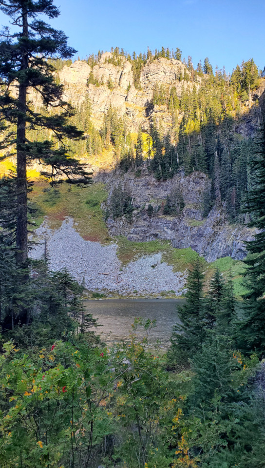 The trail is rugged. Half an hour later we reached the junction to Lake Laura.
I took the short spur to snap this photo. It's very small.
The trail is rugged. Half an hour later we reached the junction to Lake Laura.
I took the short spur to snap this photo. It's very small.
 Continue on, reached Lake Lillian in 20 minutes.
Found a couple of tents here.
Circling the lake has some problem. These's a faint trail going up into the trees to get around a large boulder.
We actually scrambled over on its surface. Needs care.
On the way back, we took the long detour in the trees to avoid this sketchy boulder.
Continue on, reached Lake Lillian in 20 minutes.
Found a couple of tents here.
Circling the lake has some problem. These's a faint trail going up into the trees to get around a large boulder.
We actually scrambled over on its surface. Needs care.
On the way back, we took the long detour in the trees to avoid this sketchy boulder.
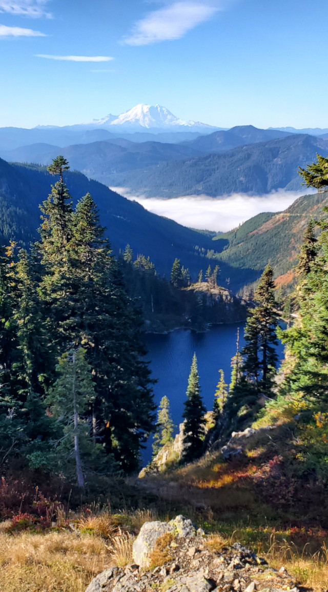 At the north end of Lake Lillian, zigzag up a steep hill. Good trail, so no problem.
As we got higher, great view of the lake below and Mount Rainier in the distance.
Once reached the ridge, need to head left. Somewhat faint trail, but it'll become obvious later.
Saw a grouse here.
S.W. went over and down the ridge. Me and Aiden followed the main trail.
Took us sometime to regroup. S.W. claimed that he found a great campsites.
While waiting for S.W. to scramble back up, Aiden coached his g.f. on some of her homework on the phone!
Here, huckleberry galore.
At the north end of Lake Lillian, zigzag up a steep hill. Good trail, so no problem.
As we got higher, great view of the lake below and Mount Rainier in the distance.
Once reached the ridge, need to head left. Somewhat faint trail, but it'll become obvious later.
Saw a grouse here.
S.W. went over and down the ridge. Me and Aiden followed the main trail.
Took us sometime to regroup. S.W. claimed that he found a great campsites.
While waiting for S.W. to scramble back up, Aiden coached his g.f. on some of her homework on the phone!
Here, huckleberry galore.
 Continued on, we met a group of 4 people at a creek crossing.
Didn't even notice the trail fork, took the left track into another small lake basin with nice fall color. Would be a nice camp spot.
Continued on, we met a group of 4 people at a creek crossing.
Didn't even notice the trail fork, took the left track into another small lake basin with nice fall color. Would be a nice camp spot.
 Getting over and steeply down to Rampart Lakes basin.
Started seeing many backpackers. Plenty lakes to choose for the night.
So many side trails: need a GPS map here.
Getting over and steeply down to Rampart Lakes basin.
Started seeing many backpackers. Plenty lakes to choose for the night.
So many side trails: need a GPS map here.
 Passing all these lakes, continue into the trees.
A major trail junction (no signs) to Rachel Lake.
We stayed straight gaining elevation. Soon can see Rachel Lake below.
At the next junction, didn't even see the junction, almost went down to more lakes.
Back tracked, going up aggressively for a short while.
Passing all these lakes, continue into the trees.
A major trail junction (no signs) to Rachel Lake.
We stayed straight gaining elevation. Soon can see Rachel Lake below.
At the next junction, didn't even see the junction, almost went down to more lakes.
Back tracked, going up aggressively for a short while.

 From now on, it's on a ridge with lovely fall color, view to both sides.
The peak looming head is not Alta Mountain.
After this peak, it is a fun, easy scramble. Maybe 0.5 miles. Saw quite a few people both ways.
From now on, it's on a ridge with lovely fall color, view to both sides.
The peak looming head is not Alta Mountain.
After this peak, it is a fun, easy scramble. Maybe 0.5 miles. Saw quite a few people both ways.

 The summit has plenty space to spread out.
Great view, so many peaks, and yes, I-90!
Interesting to see where I hiked last weekend. You can see PCT cutting into the slopes to our west.
S.W. stretched his Swaraj flag. It took some time.
He completely ignored his earlier demand of turning around at 12:30. We left at 1pm.
The summit has plenty space to spread out.
Great view, so many peaks, and yes, I-90!
Interesting to see where I hiked last weekend. You can see PCT cutting into the slopes to our west.
S.W. stretched his Swaraj flag. It took some time.
He completely ignored his earlier demand of turning around at 12:30. We left at 1pm.
 On our way back, we took the eastern route south of Rampart Lakes.
It is quite different, more open, better track.
More cloudy though. One section, the color was especially good.
On our way back, we took the eastern route south of Rampart Lakes.
It is quite different, more open, better track.
More cloudy though. One section, the color was especially good.
 Back to TH ~4:30pm. They decided to stop at North Bend for ice cream.
Some traffic on I-90. Back to Belltown ~6:30pm.
Back to TH ~4:30pm. They decided to stop at North Bend for ice cream.
Some traffic on I-90. Back to Belltown ~6:30pm.
 Bright rainbow when I was walking home.


