I took both Friday and Monday off. This is a trip long in the making.
Wed & Thurs short light rain fell in the city. Our hope was up.
All 4 days are sunny and warm, little wind. Seems ideal. However ...
9/30, Friday. Long drive to Little Giant TH via I-90 and hwy-97 (Google map showed hwy-2 as closed), and back through smoke via hwy-2. Leavenworth was terrible.
Wasted a whole day and a tank of gas. At Coles Corner, we inquired the employees at the diner. That's how we were sure that hwy-2 was open.
Friday, September 30, 2022
Thursday, September 29, 2022
2022.9.29. Camina Burana at PNB
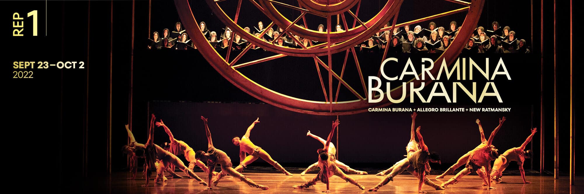 9/29, Thursday. McCaw Hall. Pacific Northwest Ballet:
- Allegro Brillante | George Balanchine
- Wartime Elegy | Alexei Ratmansky
- Carmina Burana | Kent Stowell
The two pieces before the intermission are also quite nice. I especially loved Wartime Elegy, dedicated to Ukraine. It's funny, with unique moves, when 4 male dances fall over one after another in a chain.
After the show, I attended the Q&A session with the artistic director and one dancer. The dancer talked about this falling move in Wartime Elegy, which required a lot of practice.
About 2/5 of audience didn't wear face mask.
Tuesday, September 27, 2022
2022.9.27. Whalebone Magazine Celebrates its National Park Issue
 9/27, Wednesday. I didn't knew about this event until around noon today. Went to Seattle Fjällräven store for the second stop of the Whalebone Whalebone x Fjällräven National Park Film Tour. A special viewing of the ~15min film "Born Curious", featuring Fjällraven guide JR Harris, followed by Q&A with Harfis.

 Drinks (cocktail, wine, beer, water) and cookies.
Not a large turnout. Slow going. The store opened at 6:30 for the event, but the film didn't start until maybe 7:20.
Drinks (cocktail, wine, beer, water) and cookies.
Not a large turnout. Slow going. The store opened at 6:30 for the event, but the film didn't start until maybe 7:20.
 I didn't care for the film (mostly old footage + interview of Harris inside Explorers Club or in the woods), but liked and appreciated its message: go out to the nature.
I very much enjoyed the Q&A session. Harris is very amicable and quite down to earth. I especially like the Fjällraven shirt he was wearing :)
I didn't care for the film (mostly old footage + interview of Harris inside Explorers Club or in the woods), but liked and appreciated its message: go out to the nature.
I very much enjoyed the Q&A session. Harris is very amicable and quite down to earth. I especially like the Fjällraven shirt he was wearing :)
Now, homework: I need to read the magazine.
Sunday, September 25, 2022
2022.9.24-25 Spray Park - Observation Rock - Mother Mountain Loop
9/24, Saturday. Last minute change to go south, due to the fire in the north.
I enjoyed my last climb to Observation Rock, so very happy to go back.
Being later in the season now, I didn't know what to expect. We only took micro-spikes.
 A 10+ mile detour to White River Ranger Station to get a walk-in wilderness camping permit.
The ranger is quite funny.
There were 2 parties before me, both just picking up permits, so I didn't have to wait too long.
Odd, no restroom here.
A 10+ mile detour to White River Ranger Station to get a walk-in wilderness camping permit.
The ranger is quite funny.
There were 2 parties before me, both just picking up permits, so I didn't have to wait too long.
Odd, no restroom here.
Mowich Lake TH is very busy. A campground. Multiple trails start from here. A lot of cars. We had to park pretty far away. Spray Park is always a delight. Falls color is coming nicely. Quite some huckleberries to pick. Many hikers here. On the way, a short detour to see Spray Falls. Still has plenty of water.
 After setting up the tents, we headed to Observation Rock (8228').
On the way, a lot less snow than last time (early Aug).
It was an easier walking earlier in the season, now, a little treacherous on the glacier.
Lots of crevasses, with water in them. Flett Glacier is pretty thin, so if you fall in, can probably climb out before your muscles freeze.
Micro-spikes help me steady my footsteps.
After setting up the tents, we headed to Observation Rock (8228').
On the way, a lot less snow than last time (early Aug).
It was an easier walking earlier in the season, now, a little treacherous on the glacier.
Lots of crevasses, with water in them. Flett Glacier is pretty thin, so if you fall in, can probably climb out before your muscles freeze.
Micro-spikes help me steady my footsteps.
 Once on Flett Glacier, the view is splendid.
 Passing Echo Rock (I climbed it last time), turn right on to a steeper scree slope.
Once on top, it iss easier walking all the way to the bottom of the rocks.
Passing Echo Rock (I climbed it last time), turn right on to a steeper scree slope.
Once on top, it iss easier walking all the way to the bottom of the rocks.
 Then, it's an easy and short scramble.
The summit offers a tremendous up-close view of Mt. Rainier, Russel Glaicer to the north, and Mowich Glacier to the sound, and many smaller hills and peaks all around.
Oh, yes, and the smoke to the east!
Then, it's an easy and short scramble.
The summit offers a tremendous up-close view of Mt. Rainier, Russel Glaicer to the north, and Mowich Glacier to the sound, and many smaller hills and peaks all around.
Oh, yes, and the smoke to the east!
 On the way back, we happened upon a beautiful sunset (probably due to the fire).
The sky was painted flaming red.
We sat down on rocks and waited for the sun to dip down, before scrambling back to camp.
On the way back, we happened upon a beautiful sunset (probably due to the fire).
The sky was painted flaming red.
We sat down on rocks and waited for the sun to dip down, before scrambling back to camp.
All day, we didn't see anyone, once we turned off Wonderland Trail.
The night wasn't as cold as last weekend. My 0°F bag was too warm.
9/25, Sunday. Going back on Wonderland Trail only for a little bit.
Headed up to Mount Pleasant via its west ridge. The trail was steep getting up to the ridge.
Tons of beargrass flower stalks. Need to come here in July (?) when they bloom.
Going back on Wonderland Trail only for a little bit.
Headed up to Mount Pleasant via its west ridge. The trail was steep getting up to the ridge.
Tons of beargrass flower stalks. Need to come here in July (?) when they bloom.
 We turned right (north) to Mount Pleasant (6440'). You can turn left to scramble up to Hessong Rock (6385').
At Mt Pleasant, I scouted left for a route to East Fay. The ridge is too rocky, not good with a full pack.
We continued on the trail NE, and then cut down to the trail to Knapsack Pass (part of the Mother Mountain Loop).
The view of Mist Park below, and the Cataract Creek headwater basin is beautiful.
We turned right (north) to Mount Pleasant (6440'). You can turn left to scramble up to Hessong Rock (6385').
At Mt Pleasant, I scouted left for a route to East Fay. The ridge is too rocky, not good with a full pack.
We continued on the trail NE, and then cut down to the trail to Knapsack Pass (part of the Mother Mountain Loop).
The view of Mist Park below, and the Cataract Creek headwater basin is beautiful.
 The "dotted" trail goes through the Cataract headwater basin (~6000').
Quite a few hikers are doing the loop, but most are looping clockwise to Spray Park, opposite of our direction.
Going up Knapsack Pass (~6200') is a rock scramble at the base of the steep hill.
The "dotted" trail goes through the Cataract headwater basin (~6000').
Quite a few hikers are doing the loop, but most are looping clockwise to Spray Park, opposite of our direction.
Going up Knapsack Pass (~6200') is a rock scramble at the base of the steep hill.
 Once you find the trail, it's easier going on the zigzag.
You get to see Mowich Lake from the pass.
Once you find the trail, it's easier going on the zigzag.
You get to see Mowich Lake from the pass.
 Going down, great fall color. Steep trail, but good trail.
Soon, get into the trees, and soon that's Mowich Lake.
Going down, great fall color. Steep trail, but good trail.
Soon, get into the trees, and soon that's Mowich Lake.
 Made a stop to wash at this small beach.
Paddleboards add nice color on the lake.
Walked the road back to the car.
Made a stop to wash at this small beach.
Paddleboards add nice color on the lake.
Walked the road back to the car.
A fabulous weekend.
 A 10+ mile detour to White River Ranger Station to get a walk-in wilderness camping permit.
The ranger is quite funny.
There were 2 parties before me, both just picking up permits, so I didn't have to wait too long.
Odd, no restroom here.
A 10+ mile detour to White River Ranger Station to get a walk-in wilderness camping permit.
The ranger is quite funny.
There were 2 parties before me, both just picking up permits, so I didn't have to wait too long.
Odd, no restroom here.
Mowich Lake TH is very busy. A campground. Multiple trails start from here. A lot of cars. We had to park pretty far away. Spray Park is always a delight. Falls color is coming nicely. Quite some huckleberries to pick. Many hikers here. On the way, a short detour to see Spray Falls. Still has plenty of water.
 After setting up the tents, we headed to Observation Rock (8228').
On the way, a lot less snow than last time (early Aug).
It was an easier walking earlier in the season, now, a little treacherous on the glacier.
Lots of crevasses, with water in them. Flett Glacier is pretty thin, so if you fall in, can probably climb out before your muscles freeze.
Micro-spikes help me steady my footsteps.
After setting up the tents, we headed to Observation Rock (8228').
On the way, a lot less snow than last time (early Aug).
It was an easier walking earlier in the season, now, a little treacherous on the glacier.
Lots of crevasses, with water in them. Flett Glacier is pretty thin, so if you fall in, can probably climb out before your muscles freeze.
Micro-spikes help me steady my footsteps.
 Once on Flett Glacier, the view is splendid.
 Passing Echo Rock (I climbed it last time), turn right on to a steeper scree slope.
Once on top, it iss easier walking all the way to the bottom of the rocks.
Passing Echo Rock (I climbed it last time), turn right on to a steeper scree slope.
Once on top, it iss easier walking all the way to the bottom of the rocks.
 Then, it's an easy and short scramble.
The summit offers a tremendous up-close view of Mt. Rainier, Russel Glaicer to the north, and Mowich Glacier to the sound, and many smaller hills and peaks all around.
Oh, yes, and the smoke to the east!
Then, it's an easy and short scramble.
The summit offers a tremendous up-close view of Mt. Rainier, Russel Glaicer to the north, and Mowich Glacier to the sound, and many smaller hills and peaks all around.
Oh, yes, and the smoke to the east!
 On the way back, we happened upon a beautiful sunset (probably due to the fire).
The sky was painted flaming red.
We sat down on rocks and waited for the sun to dip down, before scrambling back to camp.
On the way back, we happened upon a beautiful sunset (probably due to the fire).
The sky was painted flaming red.
We sat down on rocks and waited for the sun to dip down, before scrambling back to camp.
All day, we didn't see anyone, once we turned off Wonderland Trail.
The night wasn't as cold as last weekend. My 0°F bag was too warm.
9/25, Sunday.
 Going back on Wonderland Trail only for a little bit.
Headed up to Mount Pleasant via its west ridge. The trail was steep getting up to the ridge.
Tons of beargrass flower stalks. Need to come here in July (?) when they bloom.
Going back on Wonderland Trail only for a little bit.
Headed up to Mount Pleasant via its west ridge. The trail was steep getting up to the ridge.
Tons of beargrass flower stalks. Need to come here in July (?) when they bloom.
 We turned right (north) to Mount Pleasant (6440'). You can turn left to scramble up to Hessong Rock (6385').
At Mt Pleasant, I scouted left for a route to East Fay. The ridge is too rocky, not good with a full pack.
We continued on the trail NE, and then cut down to the trail to Knapsack Pass (part of the Mother Mountain Loop).
The view of Mist Park below, and the Cataract Creek headwater basin is beautiful.
We turned right (north) to Mount Pleasant (6440'). You can turn left to scramble up to Hessong Rock (6385').
At Mt Pleasant, I scouted left for a route to East Fay. The ridge is too rocky, not good with a full pack.
We continued on the trail NE, and then cut down to the trail to Knapsack Pass (part of the Mother Mountain Loop).
The view of Mist Park below, and the Cataract Creek headwater basin is beautiful.
 The "dotted" trail goes through the Cataract headwater basin (~6000').
Quite a few hikers are doing the loop, but most are looping clockwise to Spray Park, opposite of our direction.
Going up Knapsack Pass (~6200') is a rock scramble at the base of the steep hill.
The "dotted" trail goes through the Cataract headwater basin (~6000').
Quite a few hikers are doing the loop, but most are looping clockwise to Spray Park, opposite of our direction.
Going up Knapsack Pass (~6200') is a rock scramble at the base of the steep hill.
 Once you find the trail, it's easier going on the zigzag.
You get to see Mowich Lake from the pass.
Once you find the trail, it's easier going on the zigzag.
You get to see Mowich Lake from the pass.
 Going down, great fall color. Steep trail, but good trail.
Soon, get into the trees, and soon that's Mowich Lake.
Going down, great fall color. Steep trail, but good trail.
Soon, get into the trees, and soon that's Mowich Lake.
 Made a stop to wash at this small beach.
Paddleboards add nice color on the lake.
Walked the road back to the car.
Made a stop to wash at this small beach.
Paddleboards add nice color on the lake.
Walked the road back to the car.
A fabulous weekend.
Thursday, September 22, 2022
2022.9.22. Choir Boy at ACT
-
For half a century, the Charles R. Drew Prep School for Boys has been dedicated to the education of strong, ethical Black men. One talented student, Pharus Young, has been waiting for years to take his rightful place as the leader of the legendary gospel choir. But can he make his way through the hallowed halls of this institution if he sings in his own key? This riveting show is an intersectional coming-of-age story and a powerful examination of personal identity against institutional traditions: here, being black and queer in a prestigious all-male prep school.
Wednesday, September 21, 2022
2022.9.21. In the Time of the Butterflies at Book-it
9/21, Wednesday. First performance of  In The Time of the Butterflies at Book-it Repertory Theater. Playwright is Caridad Svich, based on the novel by Julia Alvarez.
Good acting by an all-female cast. I'm pleasantly surprised to see 2 very overweight ladies acting and acting well. I'm not sure I like the story much, because of the lack of context. I couldn't see how bad the president Trujillo was. The play only portraits him as a dictator and womanizer, and people are jailed if they are against him, but not why they were agaist the regeme. I like the singing. One set, one act. A very small audience. ~10, and not all are paying customers. I hope they'll do better later.
In The Time of the Butterflies at Book-it Repertory Theater. Playwright is Caridad Svich, based on the novel by Julia Alvarez.
Good acting by an all-female cast. I'm pleasantly surprised to see 2 very overweight ladies acting and acting well. I'm not sure I like the story much, because of the lack of context. I couldn't see how bad the president Trujillo was. The play only portraits him as a dictator and womanizer, and people are jailed if they are against him, but not why they were agaist the regeme. I like the singing. One set, one act. A very small audience. ~10, and not all are paying customers. I hope they'll do better later.
Sunday, September 18, 2022
2022.9.17-18 Copper Pass overnight
This is a short replacement of our 4-day Napeequa loop, due to weather.
It rained on Friday (hailed in the mountains).
 9/17, Saturday. I took a bus to YA's house at 7am. NP drove to Rainy Pass in her low-clearance Suburu.
The trailhead parking is a pull out north on Hwy-20, half a mile east of Bridge Creek/PCT parking, just over State Creek.
9/17, Saturday. I took a bus to YA's house at 7am. NP drove to Rainy Pass in her low-clearance Suburu.
The trailhead parking is a pull out north on Hwy-20, half a mile east of Bridge Creek/PCT parking, just over State Creek.
Copper Pass trail starts in forest, fairly easy the first 0.5 mile. The next mile gets a bit rough and steep. Once it breaks out of the trees (pretty soon), it's easy again. The trail traverses a flowering slope (better come here in summer), not gaining or losing elevation. The view over Copper Creek (it's too low to see) valley is very nice, with Stiletto (7470'), Jackknife (7680'), Switchblade (7805') peaks looming above. We met with a backpacking couple coming out. They reported freezing temperature at the pass, and snow yesterday.
 At the end of the valley, the headwater has a small pond (200+' lower than the trail), which we didn't go.
The meadow above the creek had turned a nice fall cover. It looked lovely.
I proposed to camp here (~6100', warmer, close to water, a lot of ripe huckleberries), hike up (~1200' up) to the saddle above Blue Lake in the afternoon, and climb Copper tomorrow.
NP wants to camp higher for better view, at least she agreed not to camp at the pass.
It's her hike, so we continued up.
At the end of the valley, the headwater has a small pond (200+' lower than the trail), which we didn't go.
The meadow above the creek had turned a nice fall cover. It looked lovely.
I proposed to camp here (~6100', warmer, close to water, a lot of ripe huckleberries), hike up (~1200' up) to the saddle above Blue Lake in the afternoon, and climb Copper tomorrow.
NP wants to camp higher for better view, at least she agreed not to camp at the pass.
It's her hike, so we continued up.
 Filled water at the creek by the trail. The creek was not running much.
The trail is more steep. Zigzag up. The view back towards the Copper Creek valley is nice.
We found a nice camping area ~200' below the pass. Good view, but no water.
Filled water at the creek by the trail. The creek was not running much.
The trail is more steep. Zigzag up. The view back towards the Copper Creek valley is nice.
We found a nice camping area ~200' below the pass. Good view, but no water.
 After pitching our tents, we walked up to the pass with empty packs.
At the pass, saw a couple of larch trees already turned golden.
We turned right (SW), going towards Switchblade.
Climbed one small peak, and then another. Switchblade looks a bit sketchy, a loose section in the middle.
We didn't climb there to have a good look.
Dropped down to a high plateau, full of larches.
Here, according to NP, who came from Stiletto Lake before indicates that it's possible to loop back to TH.
She said that Stiletto Lake is lovely.
We scrambled over a long rock pile, but too late to go see the lake. NP is pretty slow.
After pitching our tents, we walked up to the pass with empty packs.
At the pass, saw a couple of larch trees already turned golden.
We turned right (SW), going towards Switchblade.
Climbed one small peak, and then another. Switchblade looks a bit sketchy, a loose section in the middle.
We didn't climb there to have a good look.
Dropped down to a high plateau, full of larches.
Here, according to NP, who came from Stiletto Lake before indicates that it's possible to loop back to TH.
She said that Stiletto Lake is lovely.
We scrambled over a long rock pile, but too late to go see the lake. NP is pretty slow.
 On the way back, we filled water in the shallow creek before going up to the pass.
I couldn't find my phone. Headed back to the rock pile to look for it.
That wasted at least half an hour, and got a bit sweaty.
NP and YA were waiting for me, now in puffy jacket. Sun was setting, and it was getting cold quickly.
On the way back, we filled water in the shallow creek before going up to the pass.
I couldn't find my phone. Headed back to the rock pile to look for it.
That wasted at least half an hour, and got a bit sweaty.
NP and YA were waiting for me, now in puffy jacket. Sun was setting, and it was getting cold quickly.
Back at camp ~7pm. Cooked in dark. Very cold! Found my phone! Good star.
9/18, Sunday Drizzle when we got up. Delayed our departure.
We climbed Copper Bench. It's fairly easy. Class 1-2. Maybe one section of class 3 at the beginning.
YA is a good climber. She stayed with NP, who is not good on class-3.
I reached the summit ~8:30am (despite of many pauses to wait for my team).
The view of Washington Pass is un-surpassable.
Found 3 geo markers here!
Drizzle when we got up. Delayed our departure.
We climbed Copper Bench. It's fairly easy. Class 1-2. Maybe one section of class 3 at the beginning.
YA is a good climber. She stayed with NP, who is not good on class-3.
I reached the summit ~8:30am (despite of many pauses to wait for my team).
The view of Washington Pass is un-surpassable.
Found 3 geo markers here!
 Clouds were dissipating, however, slowly.
We stayed on the summit for ~2 hours, waiting for the clouds to dissipate.
Much better view with the clear sky. NP knows many of these peaks and routes.
Clouds were dissipating, however, slowly.
We stayed on the summit for ~2 hours, waiting for the clouds to dissipate.
Much better view with the clear sky. NP knows many of these peaks and routes.
Back at the camp for lunch. Packed up, and hiked out. We stopped at the meadow above the headwater of Copper Creek to pick huckleberries.
When getting out of NP's car, my house keys fell onto the seat. I had to call her to get the keys back. That took some time. All is well in the end.
 9/17, Saturday. I took a bus to YA's house at 7am. NP drove to Rainy Pass in her low-clearance Suburu.
The trailhead parking is a pull out north on Hwy-20, half a mile east of Bridge Creek/PCT parking, just over State Creek.
9/17, Saturday. I took a bus to YA's house at 7am. NP drove to Rainy Pass in her low-clearance Suburu.
The trailhead parking is a pull out north on Hwy-20, half a mile east of Bridge Creek/PCT parking, just over State Creek.
Copper Pass trail starts in forest, fairly easy the first 0.5 mile. The next mile gets a bit rough and steep. Once it breaks out of the trees (pretty soon), it's easy again. The trail traverses a flowering slope (better come here in summer), not gaining or losing elevation. The view over Copper Creek (it's too low to see) valley is very nice, with Stiletto (7470'), Jackknife (7680'), Switchblade (7805') peaks looming above. We met with a backpacking couple coming out. They reported freezing temperature at the pass, and snow yesterday.
 At the end of the valley, the headwater has a small pond (200+' lower than the trail), which we didn't go.
The meadow above the creek had turned a nice fall cover. It looked lovely.
I proposed to camp here (~6100', warmer, close to water, a lot of ripe huckleberries), hike up (~1200' up) to the saddle above Blue Lake in the afternoon, and climb Copper tomorrow.
NP wants to camp higher for better view, at least she agreed not to camp at the pass.
It's her hike, so we continued up.
At the end of the valley, the headwater has a small pond (200+' lower than the trail), which we didn't go.
The meadow above the creek had turned a nice fall cover. It looked lovely.
I proposed to camp here (~6100', warmer, close to water, a lot of ripe huckleberries), hike up (~1200' up) to the saddle above Blue Lake in the afternoon, and climb Copper tomorrow.
NP wants to camp higher for better view, at least she agreed not to camp at the pass.
It's her hike, so we continued up.
 Filled water at the creek by the trail. The creek was not running much.
The trail is more steep. Zigzag up. The view back towards the Copper Creek valley is nice.
We found a nice camping area ~200' below the pass. Good view, but no water.
Filled water at the creek by the trail. The creek was not running much.
The trail is more steep. Zigzag up. The view back towards the Copper Creek valley is nice.
We found a nice camping area ~200' below the pass. Good view, but no water.
 After pitching our tents, we walked up to the pass with empty packs.
At the pass, saw a couple of larch trees already turned golden.
We turned right (SW), going towards Switchblade.
Climbed one small peak, and then another. Switchblade looks a bit sketchy, a loose section in the middle.
We didn't climb there to have a good look.
Dropped down to a high plateau, full of larches.
Here, according to NP, who came from Stiletto Lake before indicates that it's possible to loop back to TH.
She said that Stiletto Lake is lovely.
We scrambled over a long rock pile, but too late to go see the lake. NP is pretty slow.
After pitching our tents, we walked up to the pass with empty packs.
At the pass, saw a couple of larch trees already turned golden.
We turned right (SW), going towards Switchblade.
Climbed one small peak, and then another. Switchblade looks a bit sketchy, a loose section in the middle.
We didn't climb there to have a good look.
Dropped down to a high plateau, full of larches.
Here, according to NP, who came from Stiletto Lake before indicates that it's possible to loop back to TH.
She said that Stiletto Lake is lovely.
We scrambled over a long rock pile, but too late to go see the lake. NP is pretty slow.
 On the way back, we filled water in the shallow creek before going up to the pass.
I couldn't find my phone. Headed back to the rock pile to look for it.
That wasted at least half an hour, and got a bit sweaty.
NP and YA were waiting for me, now in puffy jacket. Sun was setting, and it was getting cold quickly.
On the way back, we filled water in the shallow creek before going up to the pass.
I couldn't find my phone. Headed back to the rock pile to look for it.
That wasted at least half an hour, and got a bit sweaty.
NP and YA were waiting for me, now in puffy jacket. Sun was setting, and it was getting cold quickly.
Back at camp ~7pm. Cooked in dark. Very cold! Found my phone! Good star.
9/18, Sunday
 Drizzle when we got up. Delayed our departure.
We climbed Copper Bench. It's fairly easy. Class 1-2. Maybe one section of class 3 at the beginning.
YA is a good climber. She stayed with NP, who is not good on class-3.
I reached the summit ~8:30am (despite of many pauses to wait for my team).
The view of Washington Pass is un-surpassable.
Found 3 geo markers here!
Drizzle when we got up. Delayed our departure.
We climbed Copper Bench. It's fairly easy. Class 1-2. Maybe one section of class 3 at the beginning.
YA is a good climber. She stayed with NP, who is not good on class-3.
I reached the summit ~8:30am (despite of many pauses to wait for my team).
The view of Washington Pass is un-surpassable.
Found 3 geo markers here!
 Clouds were dissipating, however, slowly.
We stayed on the summit for ~2 hours, waiting for the clouds to dissipate.
Much better view with the clear sky. NP knows many of these peaks and routes.
Clouds were dissipating, however, slowly.
We stayed on the summit for ~2 hours, waiting for the clouds to dissipate.
Much better view with the clear sky. NP knows many of these peaks and routes.
Back at the camp for lunch. Packed up, and hiked out. We stopped at the meadow above the headwater of Copper Creek to pick huckleberries.
When getting out of NP's car, my house keys fell onto the seat. I had to call her to get the keys back. That took some time. All is well in the end.
Monday, September 12, 2022
2022.9.10-11 Worst Air Quality in record
 Wildfire raging in east and central Washington, causing worst air quality in 2 years in Seattle. Airnow recorded 153 on Saturday.
No excercise this weekend.
Wildfire raging in east and central Washington, causing worst air quality in 2 years in Seattle. Airnow recorded 153 on Saturday.
No excercise this weekend.
Friday, September 09, 2022
2022.9.9. Where we belong - a play
 9/9, Friday. A one woman show of Where we belong at Seattle Rep, made and acted by Mohegan playwright Madeline Sayet.
A blend of her real life episodes to showcase the acts of denial of colonialism and her own search of belonging (being maybe only a quarter of Mohegan).
Well articulated, good acting. I enjoyed the play.
9/9, Friday. A one woman show of Where we belong at Seattle Rep, made and acted by Mohegan playwright Madeline Sayet.
A blend of her real life episodes to showcase the acts of denial of colonialism and her own search of belonging (being maybe only a quarter of Mohegan).
Well articulated, good acting. I enjoyed the play.
Seattle Rep is under renovation of its main stage. The front lobby is closed, so access via the south and east doors.
Tuesday, September 06, 2022
2022.8.27-9.6 Backpacking in East Sierra - part 3/3 - Lamarck to South Lake loop
 8/30-9/5, the main backpack trip.
Day 1, TH ‐ Upper Lamarck Lake. 8/30, Tuesday.
Drove to North Lake parking lot (~9300'), sun drenched. No shade at all. Reshuffled food, relabelled all for the bear bin. Changed into a clean set of underwear and hiking pants, hiding on one side of the car. I managed to change my contact lens, thanks to CB's water jug. We also ate bananas and mandarin. I ate some bread and cheese.
 It was about 10:30 when we walked onto the toasty road to the campground. The campground itself is leafy. A mux of cottonwood and pines. A creek runs through. Quite pleasant.
At the end of the campground, a sign indicating Lamark Lakes and Piute Pass. We took the left fork, zigzagging up through the forest with plenty of shade at first. Then it's rock and sand. Some over-engineered trail with man-made rock walls.
It was about 10:30 when we walked onto the toasty road to the campground. The campground itself is leafy. A mux of cottonwood and pines. A creek runs through. Quite pleasant.
At the end of the campground, a sign indicating Lamark Lakes and Piute Pass. We took the left fork, zigzagging up through the forest with plenty of shade at first. Then it's rock and sand. Some over-engineered trail with man-made rock walls.
 I took a short detour to Grass Lake (~0.5 mile). Quite pretty with grassy shores.
 Back to the junction, soon getting out of tree cover.
Caught up CB in the sun, we both took umbrellas out.
You can see Grass Lake from here. It looks more grassy than when I was at the lake shore.
Back to the junction, soon getting out of tree cover.
Caught up CB in the sun, we both took umbrellas out.
You can see Grass Lake from here. It looks more grassy than when I was at the lake shore.
 Lower Lamarck Lake is quite pretty with towering peaks behind. I had thought about checking out Wonder Lakes. But it's too hot at 12:15. The XC route is in the sun.
We just relaxed by the lake, before heading up to Upper Lamarck Lake.
Lower Lamarck Lake is quite pretty with towering peaks behind. I had thought about checking out Wonder Lakes. But it's too hot at 12:15. The XC route is in the sun.
We just relaxed by the lake, before heading up to Upper Lamarck Lake.
 At 1:15, we reached Upper Lamarck, our 1st camp. Couldn't find a good campsite near the lake with rocky shores.
There're many good options near the trail junction on the way to Lamarck Col.
We settled here. Not far from the outlet of the lake.
I wasn't feeling very well, likely dehydrated. Rest. Wash and clean.
At 1:15, we reached Upper Lamarck, our 1st camp. Couldn't find a good campsite near the lake with rocky shores.
There're many good options near the trail junction on the way to Lamarck Col.
We settled here. Not far from the outlet of the lake.
I wasn't feeling very well, likely dehydrated. Rest. Wash and clean.
Around 5pm, we took food to the lake shore to cook dinner. Couldn't find a good flat spot in the shade. The lake is glacial blue. Saw quite some fish, small, but bigger than those in Blue Lake. As the sun moved on to us, we packed up, and walked up to the rocky butte by the outlet. The lake lost its color when the sun dipped lower.
Around 7pm, a guy waked in with a backpack. We saw quite a few earlier going by us from the Col. None stopped.
New moon. This night I just realized that we had 6 nights on this loop. I may be short on food.
Day 2, Lamarck Col ‐ Darwin Bench. 8/31, Wednesday.
 Up early. Started hiking at 7:30am, hoping for cool morning. I packed 2L water, because there's no reliable source until Darwin Lakes.
 The trail actually goes a little down, and then up a different valley.
A small snow patch to cool my water. Up one plateau and another. Seems endless, but it's less than 3 miles to the col.
You can see Upper Lamarck Lake at ~11900' if you walk over to the right at the ridge.
Occasional breeze kept sweat low. At some point I actually felt cold and put on gloves.
The trail actually goes a little down, and then up a different valley.
A small snow patch to cool my water. Up one plateau and another. Seems endless, but it's less than 3 miles to the col.
You can see Upper Lamarck Lake at ~11900' if you walk over to the right at the ridge.
Occasional breeze kept sweat low. At some point I actually felt cold and put on gloves.
 At the basin below Lamarck Col, I found a big rock with enough shade to wait for CB. Took my socks off to dry.
Filled my 1L bottle, dumped the rest of the water.
Had to put on rain jacket for the wind.
At the basin below Lamarck Col, I found a big rock with enough shade to wait for CB. Took my socks off to dry.
Filled my 1L bottle, dumped the rest of the water.
Had to put on rain jacket for the wind.
 Here, I stashed my backpack, took the water bottle, 2 bars, scrambled to Mount Lamarck.
It's all rocks. Mostly stable. Steep.
The top is almost flat, and very big. Great views all around.
Definitely a worthwhile short jaunt.
Here, I stashed my backpack, took the water bottle, 2 bars, scrambled to Mount Lamarck.
It's all rocks. Mostly stable. Steep.
The top is almost flat, and very big. Great views all around.
Definitely a worthwhile short jaunt.
 Going up and down Lamarck Col is more of a scramble than a hike.
Near the col, there's a more defined track on both sides. Lower down, tracks are all over the place.
Basically pick your own route.
Going up and down Lamarck Col is more of a scramble than a hike.
Near the col, there's a more defined track on both sides. Lower down, tracks are all over the place.
Basically pick your own route.
 Looking down the chain of 4 lakes of gradually diluted glacier color under Darwin Glacier. Super pretty.
Saw some shooting stars.
Looking down the chain of 4 lakes of gradually diluted glacier color under Darwin Glacier. Super pretty.
Saw some shooting stars.
CB found a tall rock for shade at the end of the 2nd lake, and waited for me. I stopped and took my socks out to dry. Only then, I saw that one of my foot had 3 socks on!
Continued all 4 lakes on their right (north) shore. Lots of rock hopping. At the end of the 3rd lake, we filled water, and took a break behind some sqwany trees. A ranger walked by on her way to her station at Evolution Lake. I asked her a couple of questions (Davis Lake Pass is easy, yes campsites at McDermott Lake).

 Finally got to a verdant high basin, the Darwin Bench. All along very pretty.
Took us awhile to find a shady campsite. We were spent, even though we hiked maybe only 6 miles. It's very hot.
Finally got to a verdant high basin, the Darwin Bench. All along very pretty.
Took us awhile to find a shady campsite. We were spent, even though we hiked maybe only 6 miles. It's very hot.
After dinner, saw a climber arriving with a very small backpack. He used a bivy. We strolled around as the sun set. Some paintbrush and lupine here. Ground sheet was wet today.
Day 3, JMT, Evolution Lake ‐ Mid Fork Kings River. 9/1, Thursday.
Started walking at 8am. Going down Darwin Bench has 2 trails. We followed the one higher, but lost it frequently. At the junction of JMT/PCT, we walked straight, going downhill. No sign. I thought it was the junction of the 2 trails to Darwin Canyon. I checked my map, because the trail is in much better condition, and we started to see people. Only then, I realized that we were already on JMT, but going in the wrong direction.

 The first big lake we saw is Evolution Lake. My favorite today.
It's very large (long), many nooks and little peninsulas, ringed by meadows and clumps of trees, under towering mountains.
Saw a coyote walking by calmly.
We made a break checking out the area before continue.
The first big lake we saw is Evolution Lake. My favorite today.
It's very large (long), many nooks and little peninsulas, ringed by meadows and clumps of trees, under towering mountains.
Saw a coyote walking by calmly.
We made a break checking out the area before continue.
 The trail goes along the north shore. Lovely all the way.
At the end of the lake, rock slides to go up (~100') to another large (long) lake basin.
The trail goes along the north shore. Lovely all the way.
At the end of the lake, rock slides to go up (~100') to another large (long) lake basin.
 After a few small tarns, it's Sapphire Lake. Again, gorgeous.
Met many JMT through hikers, PCT section hikers. I asked the first few we met what their favorites were. Some answers are LeConte Canyon, Foster Pass, Donahue Pass, Kings River Canyon.
We took a break above Sapphire Lake.
After a few small tarns, it's Sapphire Lake. Again, gorgeous.
Met many JMT through hikers, PCT section hikers. I asked the first few we met what their favorites were. Some answers are LeConte Canyon, Foster Pass, Donahue Pass, Kings River Canyon.
We took a break above Sapphire Lake.
 Above Sapphire Lake, it gets more and more bleak. No more trees, a lot of rocks. Still beautiful.
I took a jaunt over Davis Lake Pass to see Davis Lakes basin.
Above Sapphire Lake, it gets more and more bleak. No more trees, a lot of rocks. Still beautiful.
I took a jaunt over Davis Lake Pass to see Davis Lakes basin.
 The pass is so flat, it even has a pond right in the middle.
I had to scramble up to see the basin below. The first Davis Lake has a very pretty glacial green.
The photo to the right is at the flat pass, looking back at Wanda Lake.
The pass is so flat, it even has a pond right in the middle.
I had to scramble up to see the basin below. The first Davis Lake has a very pretty glacial green.
The photo to the right is at the flat pass, looking back at Wanda Lake.
 I initially planned to camp at McDermott Lake, and go over Muir Pass the next day.
But it doesn't look inviting for camping. Pretty, yes. But no shade whatsoever.
Thankfully more clouds developed in the afternoon, so it was not too hot.
Here, I caught up with CB.
We pushed onwards, to Muir Pass.
I initially planned to camp at McDermott Lake, and go over Muir Pass the next day.
But it doesn't look inviting for camping. Pretty, yes. But no shade whatsoever.
Thankfully more clouds developed in the afternoon, so it was not too hot.
Here, I caught up with CB.
We pushed onwards, to Muir Pass.


 Muir Hut was locked.
The upper half of the door can be open, so we could peek inside.
It smells damp. A window, a chimney, so maybe the fireplace worked. Ring of stone bench along the wall.
Muir Hut was locked.
The upper half of the door can be open, so we could peek inside.
It smells damp. A window, a chimney, so maybe the fireplace worked. Ring of stone bench along the wall.
 Going down east of Muir Pass feels very different. Beautiful too, but all rocks, not fit for camping.
Here, the rocks have red streaks, some are as dark as purple.
Going down east of Muir Pass feels very different. Beautiful too, but all rocks, not fit for camping.
Here, the rocks have red streaks, some are as dark as purple.
 After Helen Lake (where we refilled water), the trail meanders into a narrow canyon, Middle Fork Kings River.
More rugged.
Sometimes the creek crossing is laid by flat rocks fit perfectly.
After Helen Lake (where we refilled water), the trail meanders into a narrow canyon, Middle Fork Kings River.
More rugged.
Sometimes the creek crossing is laid by flat rocks fit perfectly.
 We were looking for campsites. The 1st lake (~11320') in the canyon has a nice campsite, and was taken.
Further down, another area was taken.
CB was getting anxious and in a foul mood, mostly because his knee was hurting.
We found some camp sites by the 2nd lake (~10840') along the river.
On my map, another ~half a mile should be an established camp area (~10580').
CB informed me that we already walked 12 miles.
We were looking for campsites. The 1st lake (~11320') in the canyon has a nice campsite, and was taken.
Further down, another area was taken.
CB was getting anxious and in a foul mood, mostly because his knee was hurting.
We found some camp sites by the 2nd lake (~10840') along the river.
On my map, another ~half a mile should be an established camp area (~10580').
CB informed me that we already walked 12 miles.
 This place doesn't have many options. My tent was squeezed between 2 trees.
Quite picturesque though. 2 pikas were chasing each other, making squeaking noise.
It was already after 5pm, and the sun was below the western hills.
I only washed socks, didn't rinse my shirt as in the previous days.
Nice sunset.
This place doesn't have many options. My tent was squeezed between 2 trees.
Quite picturesque though. 2 pikas were chasing each other, making squeaking noise.
It was already after 5pm, and the sun was below the western hills.
I only washed socks, didn't rinse my shirt as in the previous days.
Nice sunset.
Another starry night.
Day 4, JMT, Mid Fork Kings River ‐ LeCont ‐ Lower Dusy Basin. 9/2, Friday.
We started hiking at 8am. 13 minutes later, we passed a small camping area next to (but above) the creek) with trees.
 Going down the canyon for ~2000'. I wouldn't want to come up this way. It was quite hot already in the morning.
The next lake on the map (~10400') is just a meadow now, with a narrow creek in the middle. Large and pretty.
Going down the canyon for ~2000'. I wouldn't want to come up this way. It was quite hot already in the morning.
The next lake on the map (~10400') is just a meadow now, with a narrow creek in the middle. Large and pretty.
 The trail continues to go down, and the Middle Fork Kings River continues to fall.
More and more trees. The canyon get a bit wider.
The trail continues to go down, and the Middle Fork Kings River continues to fall.
More and more trees. The canyon get a bit wider.
~9400', almost at the bottom of the canyon, there's this funny rock layout, named "Rock Monster" on Gaia Map. CB crawled in the jaw for photos. Flat here, possible campsite.
 Shortly after, Big Pete meadow (~9300') looks very nice. This is marked on the map as a camping area.
 Next is Little Pete meadow (~8900') where the river bends a little. It's bigger and wider than Big Pete. Also marked on the map as a camping area.
By 11am, I made it to the junction with Bishop Pass Trail (~8780'). Lowest point of our entire route. Bishop pass is 6.6 miles 3300 up' from here. A group of 5 were resting here. I chatted with them, while waiting for CB. They are from LA area, doing North-South Lakes loop. Had 2 cars at each TH.

 After they left, we visited the ranger station, just ~100' away. It was closed: a note "out patrolling".
It has 2 solar panels, an outhouse, a propane tube, lots of tin buckets, a nice porch, chair and bench.
3 deer hung out here.
While we were filtering water (walk down to the river) and eating snacks, 2 hikers walked in.
They came from Pine Creek Pass, over Star Col (Mesa Lake is very pretty), down to Desolation Lakes to Humphrey Basin, up to Piute Pass, down to Muriel Lake, up to Goethe Lake, over Alpine Col to Darwin Bench.
They both had big cuts on the leg scrambling over Alpine Col. No trail there.
They also visited Ionian Basin (south of Mount Solomon/Muir Pass).
They are heading out to South Lake TH tomorrow. Total 7 days. Very fast on their challenging route.
We rested here for ~1 hour. Saw many hikers going left and right on JMT. But no other else bothered to visit the ranger station.
After they left, we visited the ranger station, just ~100' away. It was closed: a note "out patrolling".
It has 2 solar panels, an outhouse, a propane tube, lots of tin buckets, a nice porch, chair and bench.
3 deer hung out here.
While we were filtering water (walk down to the river) and eating snacks, 2 hikers walked in.
They came from Pine Creek Pass, over Star Col (Mesa Lake is very pretty), down to Desolation Lakes to Humphrey Basin, up to Piute Pass, down to Muriel Lake, up to Goethe Lake, over Alpine Col to Darwin Bench.
They both had big cuts on the leg scrambling over Alpine Col. No trail there.
They also visited Ionian Basin (south of Mount Solomon/Muir Pass).
They are heading out to South Lake TH tomorrow. Total 7 days. Very fast on their challenging route.
We rested here for ~1 hour. Saw many hikers going left and right on JMT. But no other else bothered to visit the ranger station.

 Around noon, even though it was hot, we decided to continue up, as we were in the forest.
There's a campsite marked on my map ~700' up.
Sure thing, we found good campsites next to the creek ~9500'. No view at all.
Still too early, and enough clouds were providing some shade off and on.
We decided to continue up. Met a young lady with 4 loaded mules delivering supplies to the ranger stations below.
Apart from her, we saw only 1 young guy, and 1 senior lady going down on this trail. No longer on JMT.
Saw some big Bristlecone Pines along the zigzag higher up.
As you go higher and higher, better view of the Middle Fork Kings River canyon.
Around noon, even though it was hot, we decided to continue up, as we were in the forest.
There's a campsite marked on my map ~700' up.
Sure thing, we found good campsites next to the creek ~9500'. No view at all.
Still too early, and enough clouds were providing some shade off and on.
We decided to continue up. Met a young lady with 4 loaded mules delivering supplies to the ranger stations below.
Apart from her, we saw only 1 young guy, and 1 senior lady going down on this trail. No longer on JMT.
Saw some big Bristlecone Pines along the zigzag higher up.
As you go higher and higher, better view of the Middle Fork Kings River canyon.
 Lower Dusy Basin (~10700') is gorgeous. We were both exhausted due to the heat.
 Many campsites by the lake, but none in shade. Found 2 sites far apart half in shade.
 I washed my hiking pants (and socks and shirts). Laid then on trees to dry.
The lake is shallow, warm, full of sediments, some algae, lots of reeds, not good for washing.
Fish jumping, ducks swimming, idyllic.
I washed my hiking pants (and socks and shirts). Laid then on trees to dry.
The lake is shallow, warm, full of sediments, some algae, lots of reeds, not good for washing.
Fish jumping, ducks swimming, idyllic.
The night wasn't cold. I had one tent door open all night, so I could see stars and the lake.
Day 5, Upper Dusy Basin. 9/3, Saturday.
We decided to leave 30 minutes later than usual. At 8:30am, it was already too warm.
 The upper basin is 600' up. Many lakes. The main one closest to the trail is more convenient, and also most popular.
A few tents here already. Many nice sites, but all too sunny.
I wasn't eating enough, low on energy.
CB got was disgruntle again because I went to the west side of the lake (better view).
He found more shady sites (a rare thing here due to lack of trees) at the east side, so I moved to his finds.
The upper basin is 600' up. Many lakes. The main one closest to the trail is more convenient, and also most popular.
A few tents here already. Many nice sites, but all too sunny.
I wasn't eating enough, low on energy.
CB got was disgruntle again because I went to the west side of the lake (better view).
He found more shady sites (a rare thing here due to lack of trees) at the east side, so I moved to his finds.
 Laid ground sheet at the camp to "mark my territory".
I ate a tuna packet and an Epic bar, hoping to boost energy.
We took off with a day pack in search of 3 other lakes east of a low ridge.
They are right under the rocky peaks, very pretty, but no trees to provide any shade.
Laid ground sheet at the camp to "mark my territory".
I ate a tuna packet and an Epic bar, hoping to boost energy.
We took off with a day pack in search of 3 other lakes east of a low ridge.
They are right under the rocky peaks, very pretty, but no trees to provide any shade.
 After filling water at the first lake, I took off for a loop over Isosceles Pass (12000') to upper Palisade Basin and back over Knapsack Pass.
I bit more than I could chew. Completely exhausted.
Up to Isosceles Pass has no track, rock hopping + path finding all the way.
After filling water at the first lake, I took off for a loop over Isosceles Pass (12000') to upper Palisade Basin and back over Knapsack Pass.
I bit more than I could chew. Completely exhausted.
Up to Isosceles Pass has no track, rock hopping + path finding all the way.
 The little tarn on the map below the pass was completely dry.
Going down the east side is not as steep. Saw 3 lakes below.
Looking down at both Dusy and Palisade basins, they don't look as pretty as when I'm in the basin.
More and more clouds.
I refilled water at the first lake.
Cut over the 2nd lake towards Knapsack Pass, Which is at about the same elevation as the first lake.
Saw a grouse here, and some bright pink willowherb.
Eventually I hit a trail, which goes up at least 100' unnecessarily.
The trail is well established. It's on the right side of the pass as you go up.
Getting down Knapsack to Dusy also has a track initially, but I lost it soon and found some boot tracks off and on in all directions.
Getting back to camp took longer than I hoped.
The little tarn on the map below the pass was completely dry.
Going down the east side is not as steep. Saw 3 lakes below.
Looking down at both Dusy and Palisade basins, they don't look as pretty as when I'm in the basin.
More and more clouds.
I refilled water at the first lake.
Cut over the 2nd lake towards Knapsack Pass, Which is at about the same elevation as the first lake.
Saw a grouse here, and some bright pink willowherb.
Eventually I hit a trail, which goes up at least 100' unnecessarily.
The trail is well established. It's on the right side of the pass as you go up.
Getting down Knapsack to Dusy also has a track initially, but I lost it soon and found some boot tracks off and on in all directions.
Getting back to camp took longer than I hoped.
 By the time I returned to camp, I couldn't stop the heavy breathing for a long time, feeling faint.
I think I wasn't eating enough.
It rained a few drops, I hurried to set up the tent.
I ate a large dinner, and felt much better.
By the time I returned to camp, I couldn't stop the heavy breathing for a long time, feeling faint.
I think I wasn't eating enough.
It rained a few drops, I hurried to set up the tent.
I ate a large dinner, and felt much better.
Nice sunset. No more rain.
Day 6, Bishop Pass ‐ Chocolate Lakes. 9/4, Sunday.
 Back to the usual 8am start. We hiked out a few minutes earlier.
Up to Bishop Pass is many flattish zigzags. A park boundary sign right at the pass.
Down is similar, but drops more elevation.
We started to see many day hikers, and a climber for Agassiz.
Passed an empty sign on top of a very tall pole.
Back to the usual 8am start. We hiked out a few minutes earlier.
Up to Bishop Pass is many flattish zigzags. A park boundary sign right at the pass.
Down is similar, but drops more elevation.
We started to see many day hikers, and a climber for Agassiz.
Passed an empty sign on top of a very tall pole.
 Bishop lake and Saddlerock lake are both very pretty. This whole valley is quite pretty.
 We made a rest stop at Saddlerock.
The trail continues to drop elevation slowly. Passing more lakes: Timberline Tarns, Spearhead Lake.
We made a rest stop at Saddlerock.
The trail continues to drop elevation slowly. Passing more lakes: Timberline Tarns, Spearhead Lake.
 Instead of taking a longer route over Chocolate Lakes, we continued along Long Lake, hoping to set up camp at the end of Long Lake.
We didn't find any good site, and detoured to Bull Lake. Many camping choices here.
Even though not on the main drag, a lot of people come to Bull Lake.
We chatted with a couple from LA, who comes to Sierras to hike often.
They said that at late spring (May/June) is also a good time as soon as the road is clear.
Mountains are still snow cladded, lakes are frozen. Very pretty and no people.
Instead of taking a longer route over Chocolate Lakes, we continued along Long Lake, hoping to set up camp at the end of Long Lake.
We didn't find any good site, and detoured to Bull Lake. Many camping choices here.
Even though not on the main drag, a lot of people come to Bull Lake.
We chatted with a couple from LA, who comes to Sierras to hike often.
They said that at late spring (May/June) is also a good time as soon as the road is clear.
Mountains are still snow cladded, lakes are frozen. Very pretty and no people.
 After a short break, I set up my ground sheet, left my backpack there, packed a small pack with water, filter, snack, a towel and headed up to Chocolate Lakes - the 3 lakes above us next to Chocolate Peak.
Rocks here are dark red. The 3rd lake is the prettiest. Possible to continue up and loop back to Long Lake via Ruwau Lake.
I attempted to swim in the 3rd lake, but it was too cold.
Washed my shirt and pants, waited for them to dry, while admiring the beauty of my surroundings.
Some later time, CB arrived.
We hiked back together.
On the way back, I picked a mushroom for dinner.
There were quite a few along the creek up to the first lake.
Found a few big ones at Bull Lake, but all full of worms.
Gave half of my mushroom to CB to try.
After a short break, I set up my ground sheet, left my backpack there, packed a small pack with water, filter, snack, a towel and headed up to Chocolate Lakes - the 3 lakes above us next to Chocolate Peak.
Rocks here are dark red. The 3rd lake is the prettiest. Possible to continue up and loop back to Long Lake via Ruwau Lake.
I attempted to swim in the 3rd lake, but it was too cold.
Washed my shirt and pants, waited for them to dry, while admiring the beauty of my surroundings.
Some later time, CB arrived.
We hiked back together.
On the way back, I picked a mushroom for dinner.
There were quite a few along the creek up to the first lake.
Found a few big ones at Bull Lake, but all full of worms.
Gave half of my mushroom to CB to try.
 Only 4pm. Read at the camp. Cooked dinner at the little white beach. My nose bled again (the 4th time). Today is my easiest day.
Day 7, hiking out. 9/5, Labor Day.
 Started hiking out at 6:35am, hoping to catch the shuttle at 8:45. It's only about 2 miles.
Clouds even a couple of rain drops. Nice cool morning for hiking. Met hikers coming in already at this hour.
South Lake, a reservoir, is quite pretty.
Started hiking out at 6:35am, hoping to catch the shuttle at 8:45. It's only about 2 miles.
Clouds even a couple of rain drops. Nice cool morning for hiking. Met hikers coming in already at this hour.
South Lake, a reservoir, is quite pretty.
 We made to the picnic area at South Lake in 1 hour. ~9400'.
It's also the overnight parking lot. There are 2 large garbage bins, 2 vault toilets.
2 cars coming. Then I saw a couple retrieving cooler and food from the bear bin.
I asked them if they were leaving, and if so could they give one of us a ride to the road junction.
They kindly offered to take us all the way up to North Lake parking lot.
I had to ditch my non-collapsible hiking pole at the trail sign: they have a Prius, barely fit with our packs on the lap.
They live in Vegas area (Mt. Charleston). He's from New Zealand. He just climbed Vagabond Peak yesterday.
They are going to hike from Pine Creek to South Lake in 2 weeks time with a few friends.
We made to the picnic area at South Lake in 1 hour. ~9400'.
It's also the overnight parking lot. There are 2 large garbage bins, 2 vault toilets.
2 cars coming. Then I saw a couple retrieving cooler and food from the bear bin.
I asked them if they were leaving, and if so could they give one of us a ride to the road junction.
They kindly offered to take us all the way up to North Lake parking lot.
I had to ditch my non-collapsible hiking pole at the trail sign: they have a Prius, barely fit with our packs on the lap.
They live in Vegas area (Mt. Charleston). He's from New Zealand. He just climbed Vagabond Peak yesterday.
They are going to hike from Pine Creek to South Lake in 2 weeks time with a few friends.
Back to the sun drenched parking lot. It wasn't too hot yet. Ate and changed. Headed out.
85°F at 9am,Bishop. 98°F ~noon, at Reno for gas.
Subscribe to:
Comments (Atom)