Day 1, Cottonwood Lakes. My permit requires that I spent first night in one of these lakes.

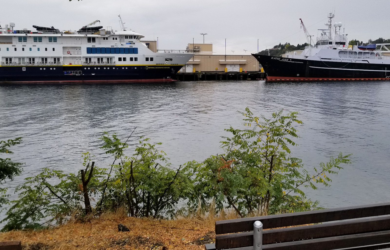
Nice view of Owen's Valley driving up to almost 10,000', then the road drops a little to Horseshoe Meadow. Multiple parking lots and campgrounds here. No sign of forest closure. A few cars parked at Cottonwood Lakes TH. A water spiget and an outhouse, some large display panels. Multiple bear boxes. Elevation ~10000'. 60°F at 9am. It was 72°F at 8am at Lone Pine.

The first couple of miles is boring, sandy, dry, enough trees to offer some shade. Met ~2 groups hiking out. ~an hour later, reached an open meadow. Soon enters John Muir Wilderness (from Golden Trout Wilderness). Cottonwood Meadow is huge, very pretty. A few dried up ponds. Not sure what this hut is for.

There are many lakes in this area. I only walked by #3. It's very pleasant, plenty trees for shade. A side trail to the right to Muir Lake, and Lake 1 and 2 to the left. Met one guy hiking out with a fishing rod, claiming that the fishes followed his lure, but didn't bite.

As it was way too early, I continued up to lake 4 and 5. No more trees here. ~11200'.

Pitched my tent by some low bushes. I hid in half shade and read, moving myself as the sun moves to remain mostly in shade. Saw a group of 4 hiking down, and inquired about Old Army Pass, which is ahead of me. One girl said she liked it, while the other was shaking her head vigorously.
Once the sun was lower, I went up Old Army Pass to check out the trail. It's quite easy really: a clear trail all the way up. Returned to camp, and cooked dinner. Went to bed without rainfly. Stars were brilliant here. I could smell a bit of smoke. Got me somewhat worried.
Day 2, Mt. Langley and the glorious Mitre Basin. The highlight of this trip. 4 big horn sheep. 5 human.
Chilly morinng. Clear blue sky, no more smoke. Ice in water bottle. I took my 20°F bag, so I was okay. I forgot to take off the plastic cover of my jetboil when cooking breakfast, so it was burnt ‐ an extra piece of trash that I have to carry for the rest of the trip:(


At the top of Old Army Pass, a sign of Sequoia National Park boundary. The boundary goes along the ridge. From here, I continued towards Mount Langley. I intended to leave my pack at the trail junction, but I didn't see any junction. No clear trail going down to Soldier Lake drainage. I walked back and forth, looking for some suitable rocks to stash my stuff. I didn't bring a day pack, so had to pile all my junk together between rocks, so any nudge by an animal would not push them down the slope.

This sign put me to easy, because I didn't know the condition of this "dotted line" trail. I didn't realize how large the official cairns are, until I saw them.

The trail is straightforward, easy to follow, with gentle incline (on the way back I took a more direct route that required scrambling). Near the summit, I met one guy on a day climb. I inquired about the trail condition of my route to Whitney. Not only he didn't know, he thought I was lost.


There are so many wooden signs at the summit (14042'). Not sure why. You can pick one up and take a photo. I don't bother with summit registries, as usual.
Got back to my stuff, when 2 crows were picking them. They tore the large plastic bag I used to line my pack. Luckily no serious damage. I sat there for lunch. Then just hiked down the slope, eventually, I picked up a path:

Soldier Lake trail. At Upper Soldier Lake, saw 4 Big Horn Sheep. Took a snack break, filtered water: my first water since camp.

The trail continues to drop all the way to Soldier Lake. A bit overgrown. Not many people go above Soldier Lake. I tried to cut across so not to lose too much elevation, but failed.

At the east end of Soldier Lake, I picked up a faint path up a gully. It was surprisingly wet, which indicates water above.

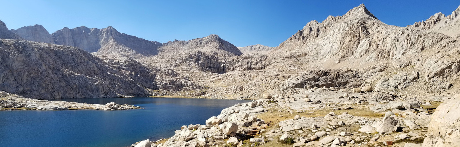
What a view awaited me at the top of the gully: Miter Basin. I cannot figure out where the water of this pond came from. No water at the other end of the pond, all the peaks around the basin are bare. This is, maybe, my favorite spot of this entire loop.

Continuing across the basin, mostly dry. I quickly lost the path. Later, I saw a couple hiking along Miter Basin trail below me. The 2 trails are supposed to converge, except that I couldn't find where my trail is. So, I headed towards them. A mile long beautiful and flat walk, along mostly dry Rock Creek, until its north end.

There's a boot track NW up to Sky Blue Lake, where Rock Creek starts. It's a beautiful lake. Stark. The couple picked their camp quickly. They were returning the same way tomorrow. I continued. Passed another camp with 2 old climbers. One guy had stretched a line for laundry. They are more knowledgeable. They said even though they haven't gone through Crabtree Pass, it is supposed to be class 2, and
Dreaded Sandhill should be worse. Other than informing me about the forest closure, one of them said I needed a Whitney Zone permit to do climb Whitney. I was sure I didn't need it, because I told the ranger on the phone that I was planning to climb Whitney. These two are climbing the Miter and other peaks east of the lake, and then will go over Crabtree Pass to climb Hitchcock and Mount Russell.

It was just past 4pm, so I continued on, because I want to be as close to Whitney as possible for tomorrow's climb. A slight regret of not able to camp at this beautiful lake. Walked along its eastern shore to the other end, and picked up a faint bootpath up, aided by my GPS map. There's a small meadow just above the lake, very pretty, maybe my 2nd favorite spot of this trip. Right now, more brown than green. It would be lovely earlier in the summer. Beyond that, a couple small cold ponds, a lot of boulders, seems like endless, until I reached this un-named lake at ~12100'.

Already 6pm, and the sun was setting. The GPS track I have goes around its western shore. But I took to the east, because I saw a flat spot for camping on the other end (marked in pink in the photo), more to the east. Took me half an hour to reach (there's some cliff I had to scramble up to go over). A nice spot, even has a bit of grass, see this photo from the next morning. Again, I didn't put rainfly on, to save time tomorrow morning (I don't want to pack up wet fly). Again, beautiful stars. It was chilly. I put my phones, powerbank and waterfilter inside of the sleeping bag. Didn't sleep well, worried about tomorrow.
Day 3, Crabtree Pass, Dreaded Sandhill, Mt. Whitney. Saw ~10 people today.

I didn't start hiking very early, because it was cold to get out before the sun reached me. Going up to Crabtree Pass wasn't as bad as I dreaded. However, I got confused at the pass. Tried 2 places to go down, and gave up both. Need to turn sharp right at the top, go around a big rock. There's a more defined path on the right. Once on the correct track, it was not too bad at all. Yes, it was steep, but not dangerous.
I hiked all the way down to the Upper Crabtree Lake (~12100'). Some people attemping Whitney from Crabtree Pass would stay high picking rock cracks under McAdie instead of going on
Dreaded Sandhill. I looked at the 3D photos of the area ahead of time, and ruled out that option, especially when carrying a heavy pack.

Found a good campsite near the outlet of the lake. Pitched my tent, dumped everything inside, filtered 1L water and carried another litre with me. See the pink line indicating Crabtree Pass on this photo with my tent.
Slogging up
Dreaded Sandhill is not fun. My shoes were filled with rocks as quickly as I could dump them. Every step forward slips backwards half a step. There're still plenty rocks to scramble over. At least the rocks here sunk in the sank nicely. It took me 2 hours to get up the first 1000'. The first 800' is very steep, and then the slope eases. Dicovery Pinnacle is ~1500' above the lake. However, I didn't expect the next obstacle. Going down to catch the Whitney trail is somewhat dangerous. This side of the ridge is loose sharp rocks. Thank god that I didn't carry a full pack. I attempted a couple of spots, and made it down without a scratch. But I don't want to repeat it.

I was in the Whitney Zone for less than 5 minutes. The west side of Trail Crest is open for all. Now only 2 miles to the summit, and on well maintained trail. Mostly flat, except at the end.

I started to see human. A couple of backpacks stashed at the trail junction of JMT. Then a hiker here, a couple there. Met a young lady ranger who informed me that the forest is closed. She asked me where I just came from and where I was heading to, and confirmed that my planned return route is the easiest. She didn't check my permit (I had it hanging outside of my pack, so easy to see).

Once awhile, you see the drop to the east side where the regular trails from Whitney Portal are. Very smokey.

The view left down to Whitney Creek drainage (JMT) is very good. Steep peaks to your right. I thought about climbing some of these when I was planning the trek, many are above 14K', but now I didn't care at all. Finally I was on the last ascent. Here you can pick your way. Nothing steep. Very straightforward. The pink circle ahead on the photo is the hut.

I arrived at the hut at 2:05pm (started from my camp at 10), 20 minutes after I saw the last hiker. Didn't see any summit registry, but a lot of names scribbled on the rocks.

Outside, more signs than on Langley. More than 1 geo-survey marks. Closer to the edge (not by the hut), I had good cell signal. SMS-ed friends. View is better than Langley, but nothing dramatic. Brown everywhere. Smoke to the east. I had the summit all to myself. That's a rare treat.
On my way back, I met range Matt Zussman(?) and his cousin Emily. They'd be the last people on the summit today. I had question regarding to my return route. Matt took time to show me the map and tell me the pro and con of my two options. I ended picking the easier way out, but less scenic. Upon knowing where I came from, he inquired the condition of Dreaded Sandhill. He claimed that the meadow above Sky Blue Lake is his favorite. He said he'd be going to Crabtree basin the next day, so I might see them. Almost right at the Whitney Zone sign, I went up Discovery Pinnacle's west shoulder (slightly more stable), detoured around its base to its east side and then go down. Maybe slightly longer, but I felt safer. Could be an illusion. It's always easier going up a slippery slope than going down. Back at camp ~5:10pm. The front of my right shoe broke off from the sole, like an open jaw. Still early enough to relax. From now on, there'd be trail, so no more worries. I put up the rainfly tonight, since I no longer need to rush in the morning.
Day 4, Crabtree drainage to Rock Creek. Saw 4 people.
Had a lazy morning, reading inside of my tent. I could finally relax. Doug walked into my breakfast. We chatted for awhile. I told him the condition of Crabtree Pass. He was on a long trip (at least 3 weeks), but his pack weighed maybe 10 ponds. Definitely no bear can (a requirement here). Still, I don't know how his pack can be this light. He even has a pen (which I don't) and a flute. He said he designed and made his pack. He's 73, lives on Big Island, doesn't want get vaccinated. He was to fly home on 9/9 and was worried that he wouldn't be let on the plane. He bragged about some secret spots with nice old growth in the Sierras, and his usual young hiking buddy. He thinks I'm fit enough to join his group. Upon hearing I have a rental car waiting at the TH, he asked for a ride to a "hidden ranch" hosted by a trail angle on my way down with maximun 2 mile detour. Sure, NP. So we set to meet tomorrow night on my last stop: Chicken Spring Lake.

Crabtree Creek drainage is quite pretty.

There's a trail off and on. If you don't see the trail, it doesn't really matter. Mid Crabtree Lake is quite big. There's a sandy beach on its north end. I could see the watermark from earlier years. Very dry this year. Lower Crabtree Lake is pretty enough, less dramatic. Saw small fish here. I made a snack stop at this lake. After this lake, the trail is obvious.
Happy to see Ranger Matt and his cousin again, going towards Crabtree Pass. I can guess where they'd camp tonight.

Crabtree Meadow is large, but dry. Only water is Whitney Creek at its west end. Saw a large camp in the woods with tool shed. Probably a work party, no one there.


Once crossed Whitney Creek, I turned left (south) onto PCT. Saw 4 deers at the south end of the meadow. Going up a rocky and dry hill, and leaf the jagged peaks behind. Now it's the monotonous sand and twisted trees. Sometimes, it's like walking on the beach, my feet sank.
I initially planned to camp at Guyot Creek, for a reasonable distance. Matt told me there's water. True, I filtered some water here, but not suitable for camping, no view, nor flat near the small creek. Even though I was tired by then, I pushed on. Downhill from here to the next camp option (6 miles from last junction at Crabtree Meadow). On the switchback I passed a lady. Just said hi. Right at Rock Creek ~9500', I was done. I didn't want to continue to the camping area (for fear of crowd, which is silly). Almost 6pm already. Pitched my tent, and washed everything inside out, including my hiking pants. I figured it's warm here at this elevation (the lowest of my entire loop), so nothing would freeze if not dried. I didn't see the lady walk by, but heard the metalic noice later when she opened and closed some bear box.
Day 5, more boring PCT. Met 3 people, only 1 new.

A couple of deer came to visit my camp while I was having breakfast. Afterwards, I burned toilet paper and oatmeal pack. It took a long time. I wasn't in a rush. 8-8.5 miles today, 2000' gain. All on PCT.
Soon after I got on trail, I came to Heather's camp, the lady I passed yesterday. She was eating breakfast with her legs in the sleeping bag. She asked if I wanted more food, because she left some in the bear box. She made the mix and dehydrated food herself. She walked with me to the bear box and showed me the properly portioned ziplock bags. Very organized, breakfast, dinner, and desert. I took one packet of dinner. She gave me the other. She's from West Virginia, on a 12-day backpack trip. She changed her route to get out of the forest earlier (instead of going north to Kearsarge Pass/Onion Valley), because of the closure, and also because she had a bad fall on day 2. This was her day 7. She showed me the photos (on her iPhone with now cracked screen) where she fell. She spent a night on a ledge sitting up. She called rescue, and Matt found her the next day, and hiked her out to trail carrying her pack. She had no serious injury, but probably twisted her knees and ankles (so she's very slow), plus a lot of scratches. Her shorts were full of duct tape. She backpacks solo every year, a couple of times. What a resilient lady. I told her that I was hiking out the next day, and if she needs a ride, just meet me at Chicken Spring. She said 8 miles and 2000' maybe a bit too much for her.


I got so accostomed to silence, was shocked when I heard a sound behind me. Jörg is going PCT southbound, a bear can tied on top of his pack. He planned to come out at Kennedy Meadow. With the forest closure, he worried if everything would be closed and he wouldn't get resupply. We chatted for a bit more. He's very fast, and soon disappeared into the woods.

It was hot, and I was bored. Slow progress. I was thirsty. No water until camp. By the time I reached the junction to Chicken Spring (~11200'), it was ~4pm, 7 hours after I left my last camp. Found a piece of paper under a rock left by "brother Doug". It's his permit with a long list of campsites. I found Doug at his camp above the pond next to the lake, stirring mashed potato. Prayer flags tied between 2 trees. He said I could pitch my tent next to his, yes, but why? I went to the lake and found a big flat area, already in shade, and set up my tent. Cleaned up, filtered water. As I was taking my bear can to head over to Doug's camp, he came by. So we walked there together. I cooked my dinner (my last freeze dried food). I gave Doug one of Heather's dinner packets, because he said his was also low on food. Then he started, in his word, jogi me, asking if I could leave my gas canister to him. Instead of taking him to his "hidden ranch", he wanted to go to Lone Pine for groceries first, and then to his "hidden ranch". A bit strange. The other thing we couldn't agree on is when to hike out. I don't want to leave early, because it's too hot down in the city. He said that he's from Hawaii, and this heat doesn't bother him, and he needed to call home. In the end, I told me I'd be at his camp tomorrow by 10am, up to him to wait or hike out by himself.
Day 6, hiking out. Met 2 hikers.

A lazy morning. I didn't bother with rainfly for the last night sky. Laid all my stuff on rocks in the sun. Read inside my tent. Cooked Heather's dinner as breakfast, the best of all my meals. She puts a lot of different things in the mix. I collected some trash before hiking out. Only 4 miles, I don't mind the extra weight.
Doug was gone when I walked by ~9:30am. Heather never came. It's all the way downhill from Cottonwood Pass, easy. PCT turns south from the Pass, and I continued on Cottonwood Pass trail to TH. Met a couple of young guys hiking in. They said they had special work permit.

This trail, even though very close to Cottonwood Lakes trail (on which I hiked in), walked by Horseshoe Meadow. It's quite pretty, large, but dry.

Once in the woods, multiple trails and roads leading to different camps, including this horse camp, which I didn't see on my day 1.
Reached the car ~noon. I moved the car in a shade, and retrieved my food from the bear box. Quickly downed a can of V8. Dumped my shoes and socks, along with trash. Washed, and then proceeded to cook lunch. Talked to a range, apparently he met Doug who told him about Heather and her fall. He was concerned. Later, 3 young girl rangers cleaning up the site. Other than these 4 at TH, I didn't see anyone else. Still quite some cars left.

Driving down the road is equally pretty. Very hot, but not as smokey as when I arrived. I drove a bit around Alabama Hills, but didn't get out of the car.
 Summary
- The most enjoyable section is from Miter Basin to Mid Crabtree Lake. Highlighted on the map with yellow over my pink route. My favorites are 1) the pond at the southern end of Miter Basin (above Soldier Lake, on the XC route), 2) the tiny meadow above Sky Blue Lake. If I had more leisure, I'd love to camp there.
- The most boring and ugly section is PCT. A more scenic return (but more elevation gain) of my last 2 days would be Upper Rockcreek to Cottonwood Lakes via New Army Pass (closer to the jagged peaks). I had enough time, so should have done that.
- The most dangerous section of this route is the 100' between Discovery Pinnacle and Whitney trail: steep and unstable slabs of rock. However, the mental drain is more of a toil, until I came back to camp from Whitney. I was overwhelmed with a dread of unknown, being totally alone in an unfamiliar location, going off-trail. Before the trip, I spent many hours researching the feasibility of my route, so I knew it was doable, but not sure if I could. I have (and paid for) a permit of 4. A few people showed interest, but none came along. The forest closure added to the risk. My last minute change of climbing Whitney with a day pack, instead of a full pack to go back via Whitney Creek drainage (GMT, as in my planned route shared with friends and family) is a prudent move. I did like Crabtree Creek drainage.
- Whitney is a boring walkup (usually super crowded), if you take the traditional trail from Whitney portal, or from the west (via GMT, most people camp at Guitar Lake). Well laid out trail all the way, no brain needed. The summit view is so-so, not worth the effort to hike it alone.
- Need to cut down my pack weight for longer trek, not sure how. I can see reducing ~2 pounds with an extra $800, but not sure what else to cut.
- I burnt used toilet paper and paper packages of breakfast oats. It's surprising how long this takes, and it never burnt cleanly. I had to collect the remnants and carry out.
- Certainly this solo trip boosted my confidence level in the wilderness.
 The first ~7 miles is straightforward, gaining only ~1700'. But it was warm, and I was sweating. We made good time. Surprising, I actually saw a couple of short larch trees by the trail (~3700'). Around 3pm, just before Cascade Creek TH turn off, we took off to the right onto the slope. The first 500' is bushy, many down logs. W and Z were lagging behind, especially Z. Then rocks, and then big boulders.
 The sun set as we were scrambling the large boulders (see ZL and W in the photo, circled in red). Nice colors. As it got darker, some of us were getting even slower. Yes, safety first. ZL never expected that we were so slow. I couldn't find my headlamp. With the half moon, I hopped rocks between D and Ir without any problem. The 3 of us decided to cook dinner when we reached the elevation of camp (~6000'), but we couldn't figure out where exactly is the camp area, advertised by ZL: large enough to fit an army. We sat there, ate, while waiting for the other 3. When everyone got here, we continued, ZL gave me a pen light. In the dark, we overshot the camp. ZL asked us to wait, and went alone to look for the spot which he visited before. Finally, we heard him whistle, and the rest 5 of us headed towards the sound. It is a very nice grassy site, with trees for shelter. By then it was already past 10pm. ZL wanted to go up to the ridge next morning for sunrise, so he asked if we could be ready to hike at 6am. This caused noticeble grunt!
 9/25, Saturday. I set my alarm clock at 5:30am, since I didn't need to cook (didn't bother to bring a stove). But I woke up by Ir's alarm: she needs time to brew coffee. Still she is the last person to be ready. We headed out without needing headlamp. Of course, this group is not going to scale 1000' rocks in an hour. The sun rose as we were going up. The slope gets steeper the higher it is. ~6700', we hit water. Stay on the creek bed clambering up the rocks and some trees, a few larches. At some point, D and I took off on the right side of a band of trees on a scree field, holding on the trees. Before the top of the slope, I checked the map, we need to be on the left side of the creek. D and I gingerly manouvered above the tree band. That was sketchy. I saw someone below, and yelled "don't follow us".
  Soon, we reached the outlet of Crystal Lake. It turned out Z, the weakest of the group, followed me onto the scree field. ZL went to rescue her. The rest of us waited by the lake, D cooked coffee. I washed my shirt. 3 goats joined us. This is the first time for D and W to be in Enchantments. We were all very happy to relax by the lake. A camper walked by us, and we apologized our boisterousness.
 We walked to Perfection Lake together, maybe the largest lake here. ZL setup a tripod and took group photo. I walked away, and waited for them ahead. W claimed that this is the most beautiful lake he has ever seen. Afterwards, we split. ZL and I went to climb, the other 4 looped to Vivian Lake and Prusik Pass. They were taking it easy, didn't even go to Upper Enchantment. Ir gave me her helmet (ZL's spare).
 I like going up to Prussik Pass, because this huckleberry dense meadow (no berries), and also because it's not on the thoroughfare for the thru-hikers. Prussik Peak looms ahead, daunting.
  Once over the pass, we followed the trail to go down (eventually to Shield Lake). Instead of losing 400' following the track that I downloaded, we left the track, scrambled along the solid rock slope, avoiding steep drops. I put on helmet, just in case.
At this lovely pond, I saw a couple resting by the water. Around here we overtook a climber who came up below (probably following the track). They were all going to Cannon Mountain, just like us.
Once over the pass, we followed the trail to go down (eventually to Shield Lake). Instead of losing 400' following the track that I downloaded, we left the track, scrambled along the solid rock slope, avoiding steep drops. I put on helmet, just in case.
At this lovely pond, I saw a couple resting by the water. Around here we overtook a climber who came up below (probably following the track). They were all going to Cannon Mountain, just like us.
 North of the pond, we started scrambling up ~800' to the west ridge. It gets steeper as it gets higher. But not dangerous: plenty grass and occasionally a small larch, nothing loose.
  At the crest, it's a flat area larger than a football field. Walked across this plateau, then it's rock scramble. It got steeper at the top section.

 The summit block is not steep, but no hand/foot hold, a bit scary. You rely on the friction of the rock surface. It's a bit small for both of us to sit on it, if we want to take panorama photos. I crawled down first, then took more photos. Lunch here. The other three also arrived.
 On the way back, I filtered water by the pond. ZL wanted to take photos. So I waited by the pond. This is really a lovely vally. No one else, only these 5 who climbed Cannon. After awhile, I called to ZL, no response, so I headed back to Prussik Pass. Again, I tried not to drop too much elevation, so scrambled on the rocky slope, but ended going to a wrong direction. Fortunately I found out not too late. From time to time I blew my whistle if I thought I may have seen ZL. But he was no where to be found.
 Back at Prussik pass, it was only 2pm, so I followed one of the many tracks up the west ridge towards Enchantment Peak. The best is keep a bit lower on the left (south) side of the ridge. Lots of red here. Even though I was tired, I had time and the slope is gentle, so slowly I drudged up. I set my return time at 4. A boot track can be found most of the way. The very top, need to go from the left (south) side. The summit block is steep, tiny hand/foot holds spaced a bit too far apart.
  As I was contemplating this rock, I heard someone calling "I finally found you". I was very happy to see ZL. Since I left Prussik Pass, I hadn't seen anyone. I climbed to the summit (another flat rock on top of this one) and came down the rock to wait for him at a safe spot. He apologized that he was spending too much time taking photos. Ah, no need. It's so beautiful. Take your time.

 We started down ~10am. First, visited the open meadow just south of our camp, and went down from there, more east to our ascent.
We went down slowly, no rush. Ir and I were taking turns of scouting the route, and the other one watching over Z to make sure she was okay. Once we heard water, I started looking for the big boulder where we filled water on the way up. Ir said that she made a note and it was exactly at 5500'. At one point, I asked them to wait for me, and I left my pack nearby, and scrambled right (west) to look for my helmets. It took quite some effort, but I found them. But no headlamp. Ir was reading when I returned. I repacked. Never ever I hiked with 3 helmets!
We started down ~10am. First, visited the open meadow just south of our camp, and went down from there, more east to our ascent.
We went down slowly, no rush. Ir and I were taking turns of scouting the route, and the other one watching over Z to make sure she was okay. Once we heard water, I started looking for the big boulder where we filled water on the way up. Ir said that she made a note and it was exactly at 5500'. At one point, I asked them to wait for me, and I left my pack nearby, and scrambled right (west) to look for my helmets. It took quite some effort, but I found them. But no headlamp. Ir was reading when I returned. I repacked. Never ever I hiked with 3 helmets!
 At the lower bushy section, we hit a track with pink ribbons on the trees. We reached trail more east to our entering point. My black shirt was cover with fireweed.
  At the first camp site (a group with a dog left their packs there), we dumped our packs and took a long break at Ingalls Creek. We all washed our feet and rested before continuing at ~4:15pm. We reached the car 2.5 hours later, very fast. Drove off at 7, still bright.