4/21, Wednesday. Took Amtrak from Seattle at 9:45am, scheduled to arrive at Sacramento at 6:35am the next morning. At the station, I was assigned a seat. Right now, it runs at 50% capacity: the middle 2 seats are not for sale, so each passenger has the whole side (2 seats on each side of the isle). However, the train was not cleaned thouroughly: a ziplock bag with food crumbs in the seat pocket in front of me, hair and debris in the lounge car armrest.
 The couch seats are big and comfortable, with an adjustable foot rest, ample leg room (~twice as much as on a plane's main cabin). On the back of the seat, tray table and foot rest. 2 AC power plugs on the wall. I couldn't tell the difference, in terms of seats, between the couch class and the business class.
I like the lounge car: large windows. Good view to the outside. I went there as soon as the train left Seattle, and stayed till lunch time. Didn't go back later, assuming it was full.
There's a lady's room, two wash basins, a seat bench, has a toilet inside. I use this instead of the toilets outside.
The couch seats are big and comfortable, with an adjustable foot rest, ample leg room (~twice as much as on a plane's main cabin). On the back of the seat, tray table and foot rest. 2 AC power plugs on the wall. I couldn't tell the difference, in terms of seats, between the couch class and the business class.
I like the lounge car: large windows. Good view to the outside. I went there as soon as the train left Seattle, and stayed till lunch time. Didn't go back later, assuming it was full.
There's a lady's room, two wash basins, a seat bench, has a toilet inside. I use this instead of the toilets outside.
We were on time till Portland. A couple of cars were added to the front of our train, took longer than normal. So we left Portland late. ~1 hour later, we stopped, the loudspeaker said that we may have to wait for another engine to be delievered from Portland, because the 2nd engine onboard didn't start properly and there was an incline soon which needs 2 engines. Thankfully, the engineer onboard was able to restart the 2nd engine, so we continued south.
I didn't take a day off from work, so worked from my phone's mobile hotspot (no WiFi onboard). I got a bit dizzy reading computer screen on the moving train, fell alseep ~sunset.
Face mask is required onboard. However, almost half of the passengers didn't mask properly. The guy snoring behind my seat had his mask on his chin only. While awake, he coughed from time to time, suspicous of covid. The lady across the isle from me chatted on the phone often, and with everyone walking by, mostly had her nose uncovered. Loudspeaker repeatedly reminds passengers to cover our nose and mouse, except when actively eating or drinking. One lady emphasized what "actively" means a few times. A noisy environment.

 4/22, Thursday. We arrived ~7:30am. Not too bad. The Sacramento train station is in a nice building, but unfriendly staff. Restroom closed. No WiFi. No map, no info booth, no direction/signs for anything. One security guard, one ticketing agent.
 I was not in a hurry. O's flight would't arrive for another 2 hours. I slowly walked the ~1 mile to Hertz' office. I like K street. This Thursday morning, all was quiet.
I got a Hyundai Veloster, a strange little car with 3 doors. Drove to PCTA office on Google map, but couldn't even find a sign, let alone visiting it. Continued along Sacramento River, checked out Sacramento Bypass Wildlife area (nothing much to see, not even water), before going to the airport. My instruction was "2nd floor, 1st exit", which is hard to follow. I drove to terminal B arrival (turns out it is downstairs). O didn't check in any luggage. Suprising to know that TSA let tent stakes in the cabin. She called for a lunch stop, and picked a Chipole 3 miles from hwy exit! At least we found a Winco so she could stock up water and juice.

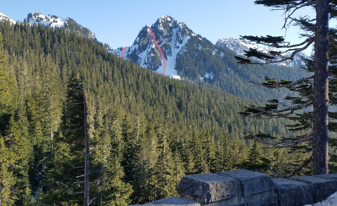
 Hwy 120 is very windy. It goes up ~6200' before dropping down to Yosemite National Park. Along the highway, quite some blue flowers (lupine, camas) in Stanislaus National Forest. This is our first view of Half Dome ‐ the main objective of this trip.
  Then Wildcat Creek Falls, Cascade Creek Falls. Once in the valley proper (~4000'), there was a ~20-30 min delay due to road work eastbound. Water level was a bit low, calm, but the waterfalls were flowing nicely: Bridalveil Falls, Ribbon Falls, Horsetail Falls. Kayak in river. Sandy beach. Pictureque.
At the visitor center (closed), we filled out a wilderness permit, marked the number of nights on a form. Before May, no reservation is needed. Two rangers outside under 2 separate tents answering questions. One told me that bear can was not needed at Little Yosemite Camp (I brought mine in vain), because there were food lockers. Redbud trees were in full bloom.

 It was still early, so we walked to Yosemite Falls. Quite busy. The trail going to Lower Yosemite Amphetheatre was close (signed for fine). On the way we walked through part of the village where the park employees live. It is a very large area. I wonder how many park employees are stationed here. Very residential: kids playing in the backyard.
The entrance to the Happy Isle trailhead parking was siged as "full". It was ~4:30pm, the parking lot was only 1/4 full. I ate more food and put food in the rusty food locker, left the empty bear can in the trunk. Saddled up, hiked towards Little Yosemite Valley camp (+2150', 4.3 mile). Saw a bear before even got to the real trail, in "The Fern" area. O continued on the track west of the river. Took some convincing to make her backtrack to the foot bridge to get to the main trail. Quite some hikers, most are coming out.
 Once the trail goes up, it's scenic: narrow gorge by rushing river. I filled water at the large stone drinking platform before Venal Falls footbridge. There's a restroom nearby.
  Afternoon sun was shining through the spray of Venall Falls. Bright double rainbow. Aptly named Mist Trail. This is closed in winter due to icy trail (alternative is JMT). At the top of the waterfall, nice slide of Merced River.
Farther up, Nevada Falls. No rainbow. Not close enough to the waterfall to get wet. Still pretty.
Afternoon sun was shining through the spray of Venall Falls. Bright double rainbow. Aptly named Mist Trail. This is closed in winter due to icy trail (alternative is JMT). At the top of the waterfall, nice slide of Merced River.
Farther up, Nevada Falls. No rainbow. Not close enough to the waterfall to get wet. Still pretty.
 We arrived at the camping area (~6200'), picked the cloest site by the camping boundary. Each site has a metal food storage box (rusty and dirty inside). There's a big fire ring. Some guy came later in the evening asking if they can setup camp fire here. It turns out that to limit the amount of fires, there're only 2 fire rings in the camping area, so these are supposed to be shared. It's a flat area, but too wooded, no view. The river is a short walk, which you cannot see from your camp. Cleaned up and rinsed my T-shirt and socks, laid them on the trees to dry. We didn't bother to cook dinner. O cooked water for tea. I ate some nuts and chocolate. Took the socks into the tent so they don't fly away at night.
4/23, Friday, sunny. Half Dome (~8800'): 7 mile RT, +/-2820'.
 My new 20°F sleep bag held out the chilly night. Tent fly was wet. My T-shirt was frozen solid on the tree, so I had to wear another T. Checked out the camping area before O emerged from her tent. Found 7 tents, 1 hammock, all in the vicinity of the fancy outhouse. The outhouse looks quite new: solar panel, 4 stalls on the 2nd level (2 were closed). O later told me that it's clean, with TP and motion sensor sanitizer dispenser. I filtered water (I never saw O filter water). We cooked breakfast. Sun slowly moved into the camp.
 Finally we set off. The trail is somewhat boring. Over-engineered: a lot of unneccessary stone steps (a waste of limited public funds). Gentle grade. A few fallen logs on the trail (none was cleared this year). First mile (~900') to junction of JMT. Another mile (~900') to a large flat area. Good view from now on (~7900'). Then serious zigzag stairs going up a butte.

 A lot of signs, not just at trail junctions: "cable is down", "dangerous", "no camping above 7600'", "if thunderstore is looming in the horizon, do not pass"... If some idiots got fried on the cable by lightening, I consider it a good thing for the human gene pool. Saw a gecko.

 After a short descent, we were at the saddle in front of the cable. A guy was gearing up slowly with harness. O brought a sling with carabinas, which is wise. I had nothing. Stashed my hiking pole and water bottle inside my backpack. Put on gloves, held on one thick cable (there are two), and up I went. O next, and the guy followed last: he had a prusik on each cable, very secure. The surface of Half Dome is quite grippy. From time to time, I could find a nook to stand, and rest my arms: the cables are heavy. The middle section is very steep. One section of the cable was up. I didn't feel any danger.
 Maybe ~15-20 minutes only, we were on the top, ~11am. Marmot and Western Grey Squirrel. The Squirrel followed me around. The marmot ignored me. On a clear day like today, the view is excellent. We walked around. There was some snow on the flat part. ~half an hour later, 2 more came up. One guy was doing a lotus pose for awhile. Stayed put for ~1 hour. We headed down ~12:30. Met a few more hikers on their way up.
It was getting hot. We hung sleeping bags and shirts on trees. I cleaned up and changed into my previously frozen T. Washed my socks again, and changed into sandals. Cooked an early dinner at 3pm!
 ~4pm, we followed Merced Lake Trail east, more or less along Merced River (but not close), in sandals. It was flat, with many fallen logs, a bit sandy. Not far from the camping area, all was burnt, result of 2014 Meadow Fire.
  The lake is more than 5 miles away, we only went to Brunnel Cascade (about halfway). The valley narrows afterwards, very close to river. I took a bio break here, rested in the shade of a big rock, before returning. O went a bit further. Saw Paintbrush here.
A warmer night. Cloudy.
4/24, Saturday, cloudy. Clouds Rest (~9900'): 12.6 mile RT, +/-4000'. Hiking out: 4.3 mile, -2150'.
We started ~8am. The first mile is the same as yesterday. At junction we saw a couple with overnight backpacks. So inquired where they camped. They came from Cloud's Rest. Discouraged me from doing the long loop (due to snow on ridge and largely burned area). The guy's phone (with Verizon) had signal, and informed us that a snow storm was coming that night. Snow level would drop to 5000'. I began to worry about the Misty Trail with snow, and also the drive out.
 After the JMT junction, a flat if not slightly downhill half mile to a 2nd junction, we took the left fork (if doing my loop, would come back on the right fork). There is water source nearby. Here, we were caught up by a guy coming from parking lot (very early). Again, over-engineered trails with stone stairs and long gentle zigzag. A couple of miles later, we reached a very large flat area. Good view of Half Dome. Then, more switchbacks, which I cut a few.

 At 9926', the view here is amazing, even on this cloudy day. The trail continues. Yes, a ridge forward covered with snow. But it's not steep on either side, should be safe. Burnt area ahead, definately. We shared some snack with the guy. He told us some alternative sights and trails in the area. He suggested detour to hwy-140 to avoid snowy road. I checked my offline map, it'll be an extra hour. He hiked down after ~45 min. A bit chilly here. We stayed a bit longer, and then headed out.
Then we met the 4th and 5th person of the day, and then ... a lot of them, many coming directly from the valley floor: 10.5 miles away (6100' EG). This reminded me that it was a Saturday. To avoid them, we cut a few zigzags, almost caught up with our new "friend". Near the trail junction, my phone showed signal. Google map painted hwy-120 red with "x". Weather.gov said possible heavy snow. So I decided to drive out tonight to below 5000'. The guy doubled back to lend us his phone. That's very kind.
Back in camp, we, again, cooked dinner at 3pm. Then packed up. It was quite sunny then, O was reluctant of leaving. Going down to the parking lot is like going to the zoo. So many people, causing bottleneck on narrow stairs. Took some manouverings to sqeeze by people. Retrieved food from the metal box. Drove out ~6pm. Traffic, very slow going in the valley, many merging traffic. Had the windows down for fresh air. O's socks (the same pair) were hard to put up for the long drive.
 We stopped at Rainbow Pool (~2800'), but it's a day use area. A family came to fish. Ended camping nearby at Middle Tuolumne River, after a bunch of kids left their fishing. It didn't rain until the next morning.
4/25, Sunday, light rain, sightseeing.
 Stopped at the next town, Groveland, to use the facilities. Cooked breakfast on their picnic table. Light drizzle. There's even a museum here, closed now (too early). My phone has no signal here. More curvey road around the town of Priest, before junction of 49. Quite scenic. We stopped at Don Pedro lake overlook: a few camper vans there. Took O'Bryne Ferry road, and stopped at Lake Tulloch. The Table Mountain north of the road is inside a fence, don't know how to access. A father and son told us they can catch many fish varieties here. Pink corncockle Then hwy-4, then Pool Station road. Very scenic: rolling hills, green grass, some trees, small creeks. All fenced private land. Bucolic. Back on hwy-49 to Jackson, a larger town (has a Walmart) to check Internet on my phone.
 I had marked a couple points of interesting on the map long ago. The first is decommissioned Rancho Seco Nuclear Station (over 30 years ago). All fenced in. Sacramento Municipal Utility converted the area to a solar farm. I've never seen so many solar panels in one place. They aim at slight different directions. While we were there, maybe at 11am on the dot, the panels tilted up a bit one row at a time. Next door is a large vineyard. Nuked grapes.
We drove to the second marker on my map, but couldn't figure out what it is for :( So continued to Sacramento, after a gas stop.
 Sacramento State Capitol was not only closed, its lawn was fenced off. It was drizzling. A roundabout filled with yellow roses.
  From there, we walked to Sacramento River. I returned earlier, as the rain got a bit heavier, and I was in sandals. Didn't want to get my last pair of clean socks too wet. I waited in the car.
  The back of the capitol (east), is a nice State Capitol Park, with a lovely rose garden. A few memorials. Some trees have labels. Many orange trees, too high for me to pick any oranges. I cooked my lunch on one of those benches, and O went to Chipole.
 After lunch, O suggested Sutter's Fort ($5). The center adobe 2-story building dates to 1841, oldest in Sacramento. John Sutter, a fortune seeker evading debt from the old world, built this fort to house pioneers and later gold diggers. He employed Hawaiians, local Indians. Sutter's son June Jr started another settlement by the river, and became the first mayor of Sacramento. There's a lady sitting in one of the many demo rooms (of course none working due to probably COVID), and another employee in the center house. They were happy to answer my questions.
Still too early to go to the airport. O suggested Leland Stanford Mansion. We arrived only a few minutes before 5pm, and it closed. Built in mid 1850s. Quite ornate.
Had to fill up gas again on the way to the airport. Arrived at SeaTac ~10pm. Lightrail was running sporatically. Waited for over 30 minutes. Got home by midnight.
Summary
- Late April, condition is perfect. No snow to worry about, temperature is mild. Weather at Little Yosemite Valley camp (Elevation 6100'). GPS map. Half Dome doesn't require a day permit (only needed from late May when cable is raised). wilderness camping permit is self-registered until April.
- Originally planed in mid March for almond bloom in Sacramento Valley. Weather.
- Train on the way in is easy to bring all gears (including isobutain gas) and drinks.
- Potential extenstion: Lake Tahoe: 2 hour drive
- Always need a plan B. I didn't plan for early exist of the park.
- Lost items: 1 knee brace, 1 sock, laptop charger and cable.