Isolde:       Annalena Persson
Tristan:      Clifton Forbis
Brangäne:     Margaret Jane Wray
King Marke:   Stephen Milling
Kurwenal:     Greer Grimsley
Melot:        Jason Collins
Conductor:    Asher Fisch
Director:     Peter Kazaras
Set & Costume:Robert Israel
Lighting:     Duane Schuler
Endless singing of night and day, love and death. Too much yearning, exaggeration, irrationality. The Isolde character goes from extremely unpleasant to ridiculous, probably just insane. Hard to feel sympathy towards her. The greatest love story, only the last 5 minutes, the 2 loves touched each other, and then one was dead. All they seek is death, only at death (for no reason) they can be united. The show starts at 6:30, ends at 11:25 (with 2 intermissions). Even though I hoped it could end sooner, I was still moved. Good voice and acting. Better orchestral music than the arias. Costume looks strange, a bit old Asian (no shoulder cut, no waist). Lighting is always excellent. Disappointing stage set: minimal, abstract. A white bed sheet hanging in the center stage on a long red line. Crumbled large box wrapped in white sheet pile on the side. I had to go to the after show Q&A to learn about the rational behind these. Philosophical: clothes go from bright red in first act, to bottom red in the 2nd, to all white in the 3rd act: signifying life fading from Isolde. White cloth separates Schopenhauer's phenomenal and noumenal. 3 times the cloth was pulled down (first time? Tristan stabbed by Melot, Tristan dies).
Thursday, August 19, 2010
2010.8.18. Tristan und Isolde
Seattle Opera's new production of Tristan und Isolde.


Tuesday, August 17, 2010
2010.8.14-15. Marmot Pass & Royal Basin
 2 hikes starting from the same trail head: Upper Dungeness River trail #833.2.
  Traditionally Marmot Pass is reached from east #833.1. This approach from the north, camping at the fork (2-3 sites right by the roaring river), allows exploring two river valleys with quite different scenery.
Day 1. Caught the 8:45am Seattle - Bainbridge ferry. Arrived at the trail head (2500 ft) ~11:30am, had lunch by the river,
 pitched the tent @ mile 1 (2900 ft) at the fork by the bridge. Crossed the bridge to the left for Marmott Pass ~1pm. Mossy floor, flat and soft, not too much undergrowth. Rhododendrons. A few small creek crossing. Almost always at the river edge. Very pleasant. @mile 3.4, a side trail to the right leads down to Camp Handy (3100 ft) on a sizable meadow by the river. Looks nice, already a tent.
Uneventful, trail starts to gain elevation. @mile 6.4 (4950 ft, 3pm) reached the junction to Home Lake Trail #893 (follow it for a minute is the Boulder Shelter, very nice camping site). Turn sharp left and up. Zigzag. Trees soon disappear.
 Flowers filled the slopes. Very colorful, some I have never seen before: Cinquefoil, Cascade Wallflower, Lance-leaf Stonecrop, Catchfly, Crazyweed, (white) Yellow Willowherb, Cliff Dwarf Primrose, Sickletop Lousewor, Moving Polemonium, Hookedspur Violet, Water Speedwell, ... Photos! Dry. Hot. Finally, almost at the end, 2 snow patches to refill the dwindling water supply.
  Reached Marmot Pass @mile 8.1 (6100 ft) shortly after 4pm. Here, you can see Puget Sound (3 cruise ships!) and the Cascades in the distance. A small group camped in the large flat meadow just east of the pass, quite a few climbed the brown Buckhorn Mountain to the north. Windy, much cooler.
 A knob immediately to the south (right) is not to be missed. Steep, slippery (I fell), little flowers dancing in the wind. A lovely flat meadow on the top, perfect for camping (albeit with company). 360° breathtaking view. Turned back ~5pm. By then, Camp Handy is crowed. Back to the tent ~8pm (1 mile from the trail head). Chilly. Total for the day: ~16 miles.
Day 2. A late start @10am. Hot. Royal Creek trail #832.

 Same mossy floor with rhodies (mushroom in autumn?), but no longer so close to the water. Mostly shaded, but drier and warmer. A couple of camp sites. Ran into an owl @11:30am. Didn't even see him, until his wing flapped my hat. After noon, trees thinned out, yet mosquitoes appeared. Occasional views promise fine vista ahead. @~5.3 miles (4700 ft) enter the Royal Basin: a large willow flat crisscrossed with small creeks and super boardwalks or steps. Mosquitoes. Large camping area (quota limited). A short climb to Royal Lake (~5100 ft, @~6.1 mile), green, nice setting, water not too cold. Air is still hot. Mosquitoes. 7 separated camp sites + 1 group site. The lake is supposed to be ringed with thousands of shooting starts. I saw less than a dozen. Not sure whether I was too late (many flowers are in seeds) or too early (still a few avalanche lilies).
 Followed the trail to the right (west) of the lake. Soon a fork to the right going down to the ranger station set in the middle of an idyllic meadow, eventually leads to a wonderful cascading waterfall. White bog orchids thrive in its mist. Retraced back towards the lake.
  At the fork, head towards a giant boulder, the trail continues up the Royal Creek to the gorgeous upper basin. Lushly green. Finally saw the long awaited snow patches. The view gets better and better. Further up among heathers and rocks is another rocky basin with a sky blue lake (~5700 ft), snowy faces of Mt Deception to the south, Mt Clark & Mt Johnson to the west, almost at arm's reach. Saw one tent, 3 more hikers and a baby.
Turned back down ~4:15pm (lost 45 minutes looking for the camera). Arrived at the tent in 3 hours. Back at car @8. 1 hour wait at the Kingston ferry. Arrived home shortly after midnight. Total: ~15 miles (+ 1.5 for the camera).
Practicality: US 101. turn left onto Louella Road (just before reaching the Sequim Bay State Park entrance). In 0.8 mile turn left on Palo Alto Road (if you missed the previous turn, Palo Alto intersects 101), for 5.7 miles. Follow the sign: turn right to FR 2880: gravel. Descends to the Dungeness Forks Campground in 0.9 mile. In another 0.8 mile bear left left on FR 2870. In ~9 miles reaches the bridge to the Upper Dungeness trailhead (also a camping ground). ~2 hrs from Kingston ferry or 2:15 from Bainbridge ferry.
Sunday, August 08, 2010
2010.8.7. Paddy Go Easy Pass
Rain. Paddy Go Easy Pass.  A lovely lake and meadow when approaching the trail head. Supposed to be good fishing here: lots of people camping along the river.
  Even though already past prime, still lots of alpine aster, larkspur, harebell, corn lily, yarrow, pink wintergreen (?), various shades of paint brushes.
The first mile (maybe less) is in the forest. Lupine leaves as big as my palm, each holding a rain drop. Then zigzip on the flowering slope. Lots of scarlet gilia, sulfur buckwheat (?). Steadily up for about 2.5 miles. Last mile is gentle, reaching a flat rocky top filled with heathers, Cusick's speedwell, miner's lettuce (Montia parvifolia var. flagellaris ?). The view to the valley floor and mountains to the northwest is nice, but could be better if not for the clouds. The trail continues north and going down. A short side spur up to the right, over some rocks leads to an edge where you can see the sprite lake. Total about 7 miles RT, 2700 ft gain.
Stopped at The Brick Tavern at Roslyn for dinner.
Practicality: 2.5 hr from Seattle. I-90 exit 80, pass Roslyn, Salmon Le Sac lake to the end of pavement (Hwy 903 North, ~18 miles from I-90). Take the right fork (#4330, instead of going straight into the campground) up towards Tucquala Lake . Bad gravel road for 10 miles. At ~1 mile north of Fish Lake Ranger Station, a small parking area to the right, just past the meadow.
 A lovely lake and meadow when approaching the trail head. Supposed to be good fishing here: lots of people camping along the river. Even though already past prime, still lots of alpine aster, larkspur, harebell, corn lily, yarrow, pink wintergreen (?), various shades of paint brushes.
The first mile (maybe less) is in the forest. Lupine leaves as big as my palm, each holding a rain drop. Then zigzip on the flowering slope. Lots of scarlet gilia, sulfur buckwheat (?). Steadily up for about 2.5 miles. Last mile is gentle, reaching a flat rocky top filled with heathers, Cusick's speedwell, miner's lettuce (Montia parvifolia var. flagellaris ?).
 The view to the valley floor and mountains to the northwest is nice, but could be better if not for the clouds. The trail continues north and going down. A short side spur up to the right, over some rocks leads to an edge where you can see the sprite lake. Total about 7 miles RT, 2700 ft gain.
Stopped at The Brick Tavern at Roslyn for dinner.
Practicality: 2.5 hr from Seattle. I-90 exit 80, pass Roslyn, Salmon Le Sac lake to the end of pavement (Hwy 903 North, ~18 miles from I-90). Take the right fork (#4330, instead of going straight into the campground) up towards Tucquala Lake . Bad gravel road for 10 miles. At ~1 mile north of Fish Lake Ranger Station, a small parking area to the right, just past the meadow.
Monday, August 02, 2010
2010.7.31-8.1 Necklace Valley
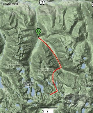
 Necklace Valley is a very long hike with mosquitoes in this time of the year. First 5 miles leveled, uninteresting (~2 hrs. I saw an owl on the way back!). Shaded, sometimes overgrown, soft footing. Obstructed view, deep valley, some bugs. Often very close to the river. After crossing a log bridge at mile 5 after a big camp site, it gets steeper and rougher (tree roots or rocks): gaining 2550 ft in 2.2 miles.
  Reached the first lake, Jade, and a camp site at ~7.5 miles (~3 hrs). Now the trail gets muddy at times, hundreds of mosquitoes descend on you as soon as you pause. At the end of this lake (good fishing?), there's a log cabin, pretty run down, but can provide shelter. Up and down, 2 more ugly lakes to Opal Lake (with a red hue), more or less at the same elevation. Keep going straight, camped at the end of the valley, where the scenery gets better (~1 hr from the first lake). It rained at night.
 Sunday, continue southwest up to Foehn Lake. ~1000 ft gain. This area is much more interesting: open, hanging ice fields, tarns with floating ice, carpets of pink and white heather. No clear trail. Some cairns identify the general direction. Mosquitoes disappeared half way up.
It's also possible to go southeast up to La Bohn Lake. The slope is steep, looks treacherous. Maybe next time. Fall is a good time. Lots of huckleberry in the valley, and more lakes to be explored.

Left the camp at 2pm, arrived at car at 7:30.
Logistics: 1:45 drive from downtown Seattle. Highway 2 ~1.8 miles east of Skykomish. Turn south on Foss River Road (#68). Keep straight for 4.1 mile (half gravel). Parking lot on the left.
7.5 mile, ~ 3000 ft gain to the first lake.
Sunday, July 25, 2010
2010.7.24. New York in 12 hours
 Landed at JFK at 6am. Took the Airtrain + subway E to Guggenheim Museum which opens at 10am. Bought a pastry recommended by the cashier at Le Pain Quotitien (didn't know it was a franchise), and went to wait in the leafy Central Park.
  8:45am at least 85°F, the park was busy with hundreds of joggers / bikers / rollers, and free hand operated bikes for handicapped (every weekend, I was told). Drinking fountain and benches near the 90th St entrance. At least here, New York city is humane and lovely (except for the heat).
Tried unsuccessfully to nap on one of the many benches along 5th ave. A long line formed in front of the museum by 10am. More than half foreigners. $18/15 is hefty for such a small exhibition. By noon, I was outside trying to resume my nap. The building itself is more interesting than what's on the walls (currently modern photographs and videos, mostly senseless). Only its Thannhauser Collection is worth some time. The two small exhibitions drawn from the permanent collection: Broken Forms and Geometry of Kandinsky and Malevich, are not too bad. The circular exhibition space allows continuous viewing. Not enough restrooms, each accommodates only one (big enough to be wheelchair accessible). Not enough benches. The complementary audio guide is sub-par (slow to load, and not mediocre content).
My uncle was able to find a parking spot right outside of the entrance. We went to lunch at Ze Cafe upon my request.

 I found it on Yelp, rated top one for brunch. The food is not as impressive as the premise: a small brick house tucked between two handsome grand buildings, sky light shines on center table laden with viennoises and flowers, walls adorned with little trees. The interior looks like a court yard. Well prepared dishes, pricey, small portion. I am very glad to see him well and chatted about our relatives. It's been over 5 years since we last met.
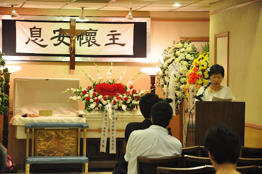 The purpose of this trip is J.C.'s funeral.
 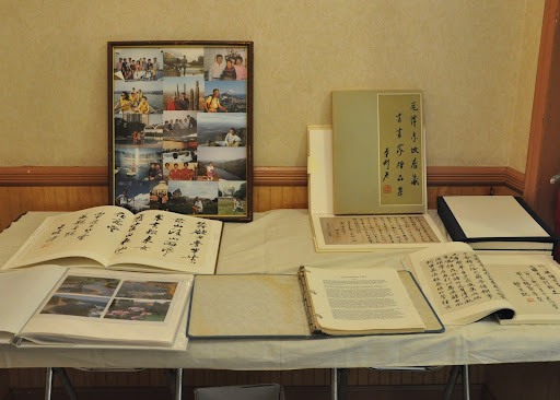 Signed my name. Brought a bouquet of white lilies and roses. The wife and son were surprised to see me. Met one other person I know (who kindly shared these photos). Helped to put up some of J.C.'s photos on the wall. It's nice to see that everyone was in good spirit, after a long battle with cancer. I left at 3:50 before most people showed up.
I got a little disoriented trying to locate the subway station. After seeking answers from 3 people in vain, I talked to a police, who also didn't know where the station was, but at least know where the street was. Amazing! After 15 minutes' walk, I was drenched in sweat. Luckily my train changed its route so I didn't need to change trains. Arrived at JFK at 5:15pm. The plane left the gate promptly, then sat on the runway for an hour, causing delay of subsequent flights. Arrived in Seattle in time for the last Light Rail train. Got home ~1am, exhausted.

New York has an efficient and frequent public transit system. However, both trains I took changed their routes. So pay attention to what the conductor says. MTA's Trip Planner is extremely helpful. Subway trains have AC, but not the stations (very stuffy without any ventilation). $2.25 per ride. $8 for 4. Airtrain $5. Parking is not difficult to find in uptown and even midtown. $2.5 per hour. Avoid JFK if possible.
Subscribe to:
Posts (Atom)