 4/13, Sunday. I was picked up at a Starbucks in SLU. 4 of us met at Northgate at 6am. We piled onto one car.
Early morning on Hwy2 is quite pretty.
We parked on Money Creek Road, just beyond a few homes, walked the Temple Mountain Road.
We could've maybe driven an extra mile in before the road gets really rough.
 Followed the road most of the time for 3~4 miles till ~3200', where we hit thick snow.
Now, donned snowshoes and took to the slope directly instead of zigzaging on the road.
We reached a small peak of ~4400' at ~11:30.
This is very narrow rocky with snow. A bit dicy. Hanging on to the trees to get forward.
Then we followed the ridge, very narrow with sharp drops on both ends until a flat plateau.
There's even a pond.
One the way back, we tried to avoid this ridge by going low. But it was equally bad, just in a diffferent way.

 Beyond this flat area lies Cleveland Mountain.
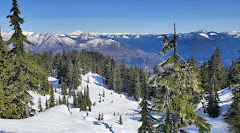
From now on, the view is excellent.
Crossed this flat area, to the right (west?) flank of Cleveland.
 From this photo taken on the way up, you can see the flat area below.
 There's only one section, near the summit, that's very steep.
Here's a photo (to the right) of my group down climbing, when we headed out.
 The view of the summit is splendid. We took a long break.
We were far away from any noise or people. No one in miles, surrounded by snowy peaks, large or small.
To the west, maybe Coney's Cone. SW: Rainier;
To the north(east), Glacier Peak;
To the southeast, Enchantments.

Going back more or less the same way, except that in order to avoid the cliff, we took to its north slope. However, that wasn't good either. Very steep. We all made it safely, but it took time.
 Back on the road, R - the organizer made us tell 2 facts and 1 lie, and make the others guess.
That helped passing the time.
The last 2 miles, we actually met 2 ladies hiking out. Not sure where they went.
They drove 1 more mile in than us.
Driving back on Hwy-2 is the usual traffic. I got dropped off ~10 minutes from my home. It was a very satisfying day.