Taking a day off to see spring flowers in eastern Gorge, due to the long drive.
4/19, Saturday, camas.

First stop,
Camassia in West Linn. I used to visit it every April when I lived in Oregon.
It was near peak. Lovely. Had lunch here.
Since this is the Easter weekend, we have painted eggs to take photo with :)
A short jaunt to
Maddax Woods, a small city park right by Willamette River, across from a cluster of trees where herons nest.
Audurbon Society was hosting a heron viewing party.
Through a binocular, you can see 3 or 4 on a single tree trunk. Saw some flurry head of the babies, if the nest is shallow.
Quite cool.

Continued driving south, we stopped at a view point at Oregon City's
Willamette Falls.
The Willamette Falls Electric Company (later renamed Portland General Electric) was formed in 1888 to build a hydro-electric generation facility at the falls.
A 14-mile long transmission line to Portland was built, becoming the first long-distance transmission of electrical energy in the United States in 1889.
There are some now defunc mills near the falls.
Most structures here delapidated, except one building. Looking old, but still generating electricity.


Oregon Garden hosts an
Earth Day event, with many environmental agencies tabling in the large gathering room.
We arrived quite late, when half of the tables were empty. Did feel some pelts: beaver pelts feel really nice!
Got some wildflower seeds. There is an alpaca decked out in colorful bows and ties for photo.
The garden itself looks nice in spring. Last time I came was winter.
Not very big, not all in flowers. Some water features.


We visited
Gordon House ($5), which is usually only open for tours.
A few volunteers were onsite to answer questions, and they also tried to engage to talk.
I didn't know that this house was moved here from Wilsonville. Certainly a nice location here.
Quite airy. kids room are upstairs. Balcony walls are very tall and blocking views.
There's a slight angle of all the junction of the surface.

On our way back north, we drove by
Woodenshoe Farm.
The parking lot was full, but we found a temporary pullover on a dirt road.
The owners of the 3 houses there are not happy with the tulip gawkers like us.


Back in Portland area, visited my last troll of Thomas Dambo in PNW:
Ole Bolle, in the grounds of
Nordoc Northwest.
He's as lovely as all the others. This one has it's own house, or maybe building his own hut.
He's bigger than the hut.
Already too late to visit the museum. Quite many little huts of different kinds in the compound.
A swing chair, some picnic tables.

Last stop of the day before hotel is Lacamas Park, a city park at the south end of Lacamas Lake.
Saw some kids fishing and diving by the lake.
Walk around the Round Lake (not round) to the other side, passing a small
dam.
Walk up a forested hill, there, you are greeted with millions of camas in bloom.
It's lovely. Quite a large area. I wonder why I had never visited this gem when I was working in Portland.

Finally, arrived at
Harrison Hot Spring hotel, already in the dark.
I brought too much junk. Stuffed the food into the fridge and went down to the pools (closes at 10pm).
We got there after 9pm (the pools, no one was at the service desk. So, no robes.
It was somewhat disappointing. The only water that has a smell of natural hotspring is the one "shower".
The "hot spring" outside is COLD and small, doesn't look like the title image of its website at all.
The full-size swimming pool is a little chilly. Not sure if it's filled with spring or not: it smells of faint chlorine.
The jaccuzzi is big and with many jets, but too crowded.
At least this is relaxing.
4/20, Sunday. Had the color eggs for breakfast.
Checked out at ~8am, still chilly.


First stop is another camas field in Calson, nearby. Overlooking Columbia Gorge, from a seemingly abandoned road (Carson Depot Road) littered with trash.
A short walk through trees and out in the open, on a bluff above the Gorge, covered with camas in bloom.
Again with mossy rocks and dwarf oaks.


Now a proper hike:
Coyote Wall - Labyrinth.
Start from a road, lined with lomatium and bachelor button, even smelled of lomatium.
Amazing amount of Triteleia grandiflora in bloom, balsamroot covered the higher portion of the wall. Lupine is still coming.

View of Columbia River below, and Mt Hood in the clouds.
The usual plethora of spring flowers, most prominent is endless lomatium (grayi, nudicaule, triteratum + maybe other species), fiddleneck, yarrow, prairie star, blue mustard, different vetches, phlox, agoseris, popcorn flower, Phacelia hastata, Phacelia linearis, whole-leaf saxifrage, larkspur, ookow, some fleabane, a lot of wild cucumber flower, pucoon (Lithospermum ruderale), some buttercup, bluebells, some claytonia, some pensemon, tomcat clover.


Going back through the volcanic rocks provides different habitat. Found lomatium columbianum (already in seeds), more phlox, some columbine. Basalt columns, and a 2 level-ed waterfall.

Drove the east end of the area, and parked at Catherine Creek, hiked
Catherine Creek + Natural Bridge.
Very happy to see the first few blooms of bitterroot (one of my favorites).
This side, we saw camas and death camas. Some shooting star near the bridge.
There's a stone arch. The top is quarrentined off.
Again, a lot of lomatium (no columbianum) and Triteleia grandiflora.


Next, drove to Oregon side to Rowena Crest.
Hike up to
McCall Point.
Here, we saw some paintbrushes, a couple of yellow bell (almost red
Fritillaria pudica), toothwort (
Cardamine nuttallii), minor's lettuce, a lot of balsamroot and Lomatium columbianum (most have done flowering).


Today it's too cloudy to see Adams. By now, couldn't even see Hood.
A bit windy up on the top ridge.
Stayed overnight at The Dalles. Convenient (near hwy exist, gas station, 2 grocery stores), but very noisy due to the highway.
4/21, Monday. Cheap breakfast at the hotel. Saw on TV that the Pope just died on Easter Sunday.

Going to
Columbia Hills State Park.
First, stopped to admire the petroglyph at the
Horse Thief Lake section.
Really peaceful in the morning.

 Crawford Oaks
 trail, which starts right next to the highway.
A lot of balsamroot as expected. More are coming. A lot of phlox too. Some lupine.
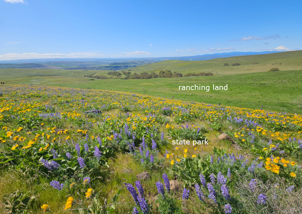
The Dalles Mountain Ranch (also part of the state park) was locked. The trail to the rusty car was also blocked.
Had to scramble from the south side over a ditch.
The most striking aspect of this hike is the clear line of protected land and grazed land.
The cattles eat basalmroot. They only bloom in the protected area.
Had lunch sitting among the flowers. I even brought a chair.
Today, it's sunny, clear view of Mt Hood.
Because it's a Monday, very few people. A little windy.

It's a 4.5 drive back to Seattle. We made a stop at
Brooks Memorial State Park to check out the area where
Mountain Lady Slipper will bloom in a month.
There's a ranger station, and as soon as we stopped, a ranger came out.
It's dry and hot here - seems an odd place for orchids.
The TH parking is out in the sun, hot.
I walked the part where the ranger showed me on the map (under pondarosa trees), slightly uphill.
No orchids now, but saw 3 plants of
grass widow (iris family). I guess it's not as dry as it seems.
Saw a bunch of cabins with no one around, and a turkey who fled from me.
Back to Seattle not too late. Rain between North Bend and Snoqualmie Pass. No much traffic.
 From the empty parking lot (1 other car), we walk the last spur road ~half mile to this sign for
Davis Peak. Elevation ~2400'. Already 11:45am!
Dry, and brown already. Still April.
From the empty parking lot (1 other car), we walk the last spur road ~half mile to this sign for
Davis Peak. Elevation ~2400'. Already 11:45am!
Dry, and brown already. Still April.
 The trail dips down to cross Cle Elum River on this fancy new-ish bridge.
Some glacier lilies on both side of the bridge access.
The trail dips down to cross Cle Elum River on this fancy new-ish bridge.
Some glacier lilies on both side of the bridge access.
 The summer trail goes all the way to Davis Peak and Davis Central all along the trail, zigzag.
Around 4500', we hit continuous snow, and trail was hit and miss. Boots were still good, however, mine leaked.
Some route finding is required.
We met one guy coming down, and told us that we needed to go over the cornice on the ridge, and north of the ridge, the snow was too deep, and he gave up because he didn't bring snowshoes.
Soon, we were on a small peak, with a survey marker. ~2:10pm.
The summer trail goes all the way to Davis Peak and Davis Central all along the trail, zigzag.
Around 4500', we hit continuous snow, and trail was hit and miss. Boots were still good, however, mine leaked.
Some route finding is required.
We met one guy coming down, and told us that we needed to go over the cornice on the ridge, and north of the ridge, the snow was too deep, and he gave up because he didn't bring snowshoes.
Soon, we were on a small peak, with a survey marker. ~2:10pm.

 There, traversed over rocks, not sure where the actual trail is.
Reached the ridge to Peak 5988 ~2:45pm. Investigated where this cornice cutoff is.
Very steep.
Decided to go over Peak 5988, and then pick the least steep slope to go down through the valley, more or less following a GPS track we downloaded. The slope
(On our way back, we did climbed through this cut-off.)
There, traversed over rocks, not sure where the actual trail is.
Reached the ridge to Peak 5988 ~2:45pm. Investigated where this cornice cutoff is.
Very steep.
Decided to go over Peak 5988, and then pick the least steep slope to go down through the valley, more or less following a GPS track we downloaded. The slope
(On our way back, we did climbed through this cut-off.)

 We made a lunch stop on top of Peak 5988. Already 3:08pm, I was starving.
Wolfed down the sandwich I made for yesterday's hike.
The view here is very good. Also good to see what was lying ahead.
My right sock was completely wet. Squeezed water out, and set on rock to dry.
We made a lunch stop on top of Peak 5988. Already 3:08pm, I was starving.
Wolfed down the sandwich I made for yesterday's hike.
The view here is very good. Also good to see what was lying ahead.
My right sock was completely wet. Squeezed water out, and set on rock to dry.

 Walking a bit north towards Davis Southwest until the lowest point, and go down the right (east) slope.
Steep, but not terrible. Snow is soft. I put on snowshoes very soon.
Then it's quite gentle going to the flat Davis Peak. 4:17pm.
A semi-circle stone wall at its east end.
Great view to the north and south (Mt. Rainier looked like a ghost, only the top tip).
Trees block the view to the west.
Walking a bit north towards Davis Southwest until the lowest point, and go down the right (east) slope.
Steep, but not terrible. Snow is soft. I put on snowshoes very soon.
Then it's quite gentle going to the flat Davis Peak. 4:17pm.
A semi-circle stone wall at its east end.
Great view to the north and south (Mt. Rainier looked like a ghost, only the top tip).
Trees block the view to the west.
 We walked a bit west towards Davis Central, hoping to get a better view west for North Davis, and the Goats.
 ~4:30pm, we headed down. Had a good view of the ridge where we came from.
We decided to try the cornice. It was very steep. Snow is soft enough, and I had ice axe.
O.K. took off her snowshoes for this slope, I kept mine.
~4:30pm, we headed down. Had a good view of the ridge where we came from.
We decided to try the cornice. It was very steep. Snow is soft enough, and I had ice axe.
O.K. took off her snowshoes for this slope, I kept mine.
 Here's a photo of O.K. gong through the cornice.
 The rest of going back is fairly straightforward. We were able to find the trail more than when when were coming up.
Got back to the bridge at 7pm.
Walked back to the car, now the only one in the parking lot.
The rest of going back is fairly straightforward. We were able to find the trail more than when when were coming up.
Got back to the bridge at 7pm.
Walked back to the car, now the only one in the parking lot.