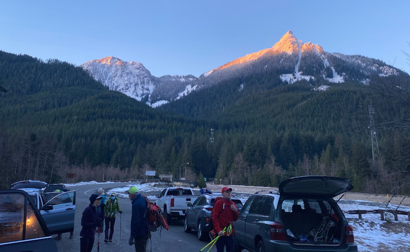
 1/9, Saturday. A rare sunny but not cold weekend day in winter. I txt-ed V the previous day, asking if he's comfortable offering me a ride, kn owing that I just returned from crowded Vegas on Tuesday. The answer is yes. So, I got up at 5:40 in order to meet the group at Eastgate at 7am in foggy darkness. Orange sky on the drive east, as the sun rose. A few others met us at TH. Total 16 (maybe 17) attended today's climb to P3. With such a large group, everything is slow, very slow. We didn't start hiking until ~8:20, at I-90 exit 42! Elevation ~1550'.
Parking along Tinham Road. Hardened snow on the sides. Put micro-spikes on. However, not really needed for the next hour. Follow the trail to Mason Lake Road. About 1/3 - 1/2 mile, all in forest, soft ground, cross Mason Creek to its left (W). Turn left, and walk the road to Mason Lake TH (accessible in summer), a little shy of 2200'. We did this part briskly. Regrouped at Mason Lake TH, shed some clothes.
 From here on, it's zigzag, nothing too steep to ~3800'. Consistent snow started ~3000', and got deeper the higher we went. From 3800', it's straight up. Very steep. See photo. At some point, the group stopped to strap on snowshoes. Me and a couple of others kept with spikes, until the guy in front of me punched into a hip deep hole. By then, we were above tree line. Good view to the south. Rainier popped its head behind the hills. On a steep hill like this, there isn't much safe place to swap gear. So we were lagging behind, which is good. The track in the snow was pounded on by those in front of me.
 At the last standing (dead) tree trunk, a girl was questioning her tube-style snowshoes. I told her that she could use mine, because I was going to change into micro-spiles. I could see that most of my group was stopping in front of some black rocks.
  I stashed my snowshoes by the tree trunk. P. followed my suit, and also ditched his backpack by our snowshoes. It was quite windy here (see photo of M). As I was approaching the rocks, I saw my group turning around. The rocks were too slick. M and M both just returned from the top. M said that if we wanted, we could continue. Thankfully 2 others also decided to continue. So 4 of us kept on. This pile of rocks is difficult. Ice axe hits a rock instead of ice, so doesn't grab. Yes, hands and knees, slowly edging up. I did bring crampons, but not useful here. I did, however, put on my helmet, just in case.
You can see Puget Sound from here, and the Olympic Mountains.
I stashed my snowshoes by the tree trunk. P. followed my suit, and also ditched his backpack by our snowshoes. It was quite windy here (see photo of M). As I was approaching the rocks, I saw my group turning around. The rocks were too slick. M and M both just returned from the top. M said that if we wanted, we could continue. Thankfully 2 others also decided to continue. So 4 of us kept on. This pile of rocks is difficult. Ice axe hits a rock instead of ice, so doesn't grab. Yes, hands and knees, slowly edging up. I did bring crampons, but not useful here. I did, however, put on my helmet, just in case.
You can see Puget Sound from here, and the Olympic Mountains.
 Above this rock pile, it was easier. Snow slope, not too steep. The very top is another pile of slick rocks, but it's a shorter section. Hands and knees again here, pick down.
At 12:48pm, finally, I was on the summit, 5220'. 4 hours for less than 3 miles. The summit offers great view, but doesn't have much room to move around.

 One more came up. A bit cold and windy here, and no place to dig food out of my pack. So, we didn't linger. We were 40 minutes behind the first one in the group who summited. Headed down gingerly.
I retrieved my snowshoes, but stashed them in my backpack, instead of wearing them. Had part of my sandwich, before continuing down.
One more came up. A bit cold and windy here, and no place to dig food out of my pack. So, we didn't linger. We were 40 minutes behind the first one in the group who summited. Headed down gingerly.
I retrieved my snowshoes, but stashed them in my backpack, instead of wearing them. Had part of my sandwich, before continuing down.
All slopes always appear much steeper on the way down. Bad for knees. Down into the trees, saw one person coming up alone. Later, saw another hiker going up alone. Not a good idea to attempt something like this alone. Back at the normal zigzag, I finally caught up with the group's tail end. Passed 3 girls. Soon, reached the group who was waiting, minus 2 who took off. I couldn't find my other half of sandwich. At the lower trail junction, lost 2 more (in the front) who continued towards Dirty Harry. On Mason Lake road, I waited for the last person at the turn. Did see everyone at the parking area. No one was lost.
Dirty boots, gaitors and spikes. I was dropped off at Issaquah, only waited 2 minutes for my bus. Perfect timing. I got home ~5:40pm. Maybe 6 miles, 3700' today.