 7/3, Friday. Left Seattle in light drizzle. Heavy traffic on I-5, many slow downs. Getting into Aberdeen on 101 is the worst. I guess a lot of people were heading out to the beaches. We stopped twice for the beaches, one I got several bee stings going through bushes. Also saw a pair of bald eagles perched on a tree very close by. The other is Ruby Beach, which has a large parking lot, a restroom, and quite a few families, despite of the gloomy weather.
At the gate of the Olympic National Park entrance, the young ranger in the booth used a long stick (probably 6') with a credit card reader attached at the end, so he didn't need to be close to the car. We finally arrived at Hoh River Visitor Center. All parking lots were still almost full. It was already 5pm. The visitor center was closed. There is a fee deposit box and registration forms. The drinking fountain was out of order. A short line outside of the restroom. The lady's room had only one sink working (the other one was just a sink with faucet removed). A little drizzle. Ate dinner outside the center, on the bench under a roof. Started hiking ~6pm. Hoh River trail, elevation ~600'. Met both day hikers and backpackers coming out. Saw one pheasant. Our destination: Glacier Meadow is in 17.5 miles!
This night, we stopped around 9pm. So far, mostly flat terrain. Some very big trees. Lichen hanging everywhere. Light drizzle, mosquito wasn't bad. My shoulders hurt. Water has a pretty pale blue glacier color.
Today's step count: 28K.

 7/4, Saturday. Sunshine mixed with clouds. The tent fly was very wet. Damp here. Continued on to Glacier Meadow, passing all the campsites, many with logical names like 12.4 mile, 13.2 mile, and 13.3 mile camp. Very few viable camping opportunities other than what's signed. Most can accommodate only one tent. Those marked on the park's map are larger. Lewis Meadow looks the nicest, at around mile 10. Lots of buttercup.
 The trail starts going up after the 12.4 mile camp. Up and downs. At ~mile 13, this new bridge looks solid and over engineered. A lot of construction material was piled at its northern end. By then, the rain forest is no more. Typical PNW matured forest.
 Finally arrived at Elk Lake (~mile 15). I was hoping for a long lunch break. But the lake front is swampy and bushy. No good place to sit. The campsites are on the hill east of the lake, without view of the lake.
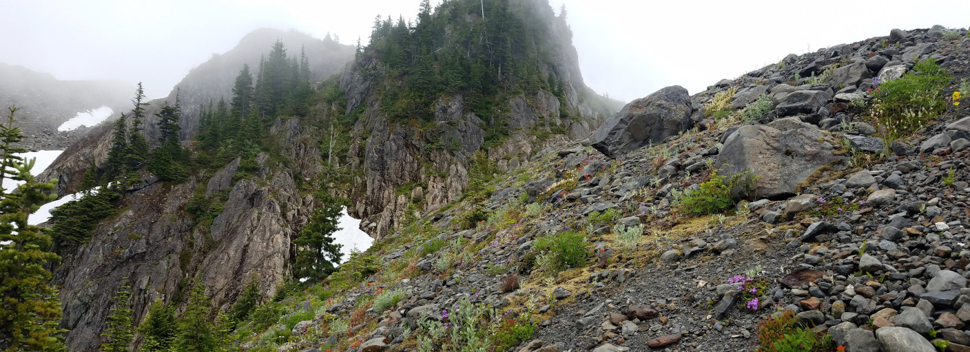
 Marching on. At around mile 17, near the "hazardous slide area", mountains start to appear across the Glacier Creek valley.
  A ladder on iron chains is dangling on the dusty slope. Another rope is fixed next to the ladder, and yet another one connects to this rope at the lower end to the side. Had to wait here for awhile. One person at a time. I don't like this one bit. I'm not a climber, so not used to rely completely on the rope. Was scared when I couldn't find foothold for so long. My water bag fell out, and I had to retrieve it. Once made to the bottom of the rope, had to walk up to regain the trail.
Finally arrived at the Glacier Meadow camp, shortly before 4pm. Avalanche lily appeared shortly before reaching the camp. A very disappointing site. No view of glacier, nor meadow. All in the trees. 2 bear wire stations. 2 shelters. Already ~10 tents here. We took camp#1, one of the nicest, just a few steps from Jemrod Creek. Relaxed for the rest of the day. Had an early dinner on the other side of the creek, and sat and read. Some mosquitoes. Clouds thickened ~5pm, and then sand. By 6:30, the camp was in the fog. Repacked for tomorrow.
Today's step count: 30K.
 7/5, Sunday. The highlight. Sunny. By the time we got up ~7am, the camp was quiet. Everyone was gone climbing. Hiking the Blue Glacier trail to the lateral moraine (1.2 mile, at 5100'). Passing the ranger's tent site near the sign of 4300', then the Glacier Meadow itself. It's a sloped meadow, quite pretty with flowers. Paintbrush here is pink. Lots of corn lily, valerian.
 The view from the lateral moraine is fabulous. All to ourselves. Blue Glacier spread below, a long frozen river of ice.
 At the southern end of the moraine ridge, located a boot path and started down the scree slope. All loose rocks. At some point, I screamed that I was turning back. I did gingerly climb back, then found a different track, and followed that one for a bit, until I lost it. Slowly edging down, sometimes on all fours, occasionally kicking off a small rock slide and dust. It took me almost ~50 minutes to get down. Once at the bottom of the moraine, put on crampons. The snow is soft enough, that I didn't use crampons on the way back.
 Blue Glacier is wider than it looks. Took us awhile to cross it. There, we started to see people. Met the first two groups (5 and 3) of climbers on the flat glacier. They didn't look happy. Yes, they were already finished! One guide said that most groups turned around at the false summit. After crossing the glacier, we headed up towards Snow Dome. On the way, met another two groups (5 and 5) coming down. They were all still on ropes.
 The upper stretch towards Snow Dome is somewhat steep. The only section I was able to glissade down. The top of Snow Dome is flat, wide and pristine. By then (~12:30), the clouds had risen. We didn't get a good view of the west side of Glacier Creek. We were afraid of not able to get up the scree in case of a whiteout, so we decided to call it quit here. From here to the saddle seems again straightforward and easy. The summit of the west peak is still ~1200' up. If we started earlier, I should be able to get to the saddle at least, maybe even the false summit. Before heading down, I walked to Panic Peak, easy solid rock. There's a cabin, an outhouse, solar panel, and a monitor device atop a tripod.
 My water bottle fell out when glissading the upper slope. The last group of 5 was behind us. Someone shouted if anyone lost a bottle. Then a lady leaped down to hand me my bottle. She was so fast, not even wearing crampons. She's in her 60's, in much better shape than I am. I asked her about the hut. She said it belongs to U. of Washington.
Back down at the Blue Glacier. One guy of this last group has 2 small Star Spangle flags in his day pack. While the rest of his group sat and rested on a rock section below, this guy went up a bigger snow patch more north, so he could minimize the time on the scree slope. The lady who handed me my bottle said: don't follow him. We went up at approximately where we came down. It's still bad, but going up is easier, and I know where I should be going. At the top of the moraine, the guy with American flag said wherever he came up is equally bad. He said, he's done this 6-7 times, and this would be his last time. 20 years ago, the Blue Glacier was twice as high. Going down the scree was much shorter and easier. We had a long break on top of this lateral moraine, enjoying the view.
 Back at the camp ~4pm, all tents were gone, except this last group. Dumped the climbing gear, washed and aired my boots. After the break, I headed up to the terminal moraine alone. It's an easy walk about 30 minutes. Clear path to follow. More rocks on trail. Not meadow-like. The moraine here also had quite some flowers. Paintbrush is scarlet here.
 Near the end of the trail, I found a lot of tubes. Not sure what the park is planning to build here. The rocks are rusty iron color. Sharp. Too cloudy to see much. I waited for 15 minutes. Gave up, and walked back to the camp. By then, the last group also left.
Warmer tonight. Nice to have the whole place to ourselves. Went to sleep early for an early depart tomorrow.
Today's step count: 28K.
 7/6, Monday. Up at 5:30am. Cooked breakfast. Very wet tent. Packed up, and hiked out in an hour. We went from above the clouds, to in the middle of the clouds, and most of the time, was under the clouds. I wasn't happy to repeat the ladder, worrying that my arms couldn't hold me. At least, we didn't need to wait. We met the first couple of hikers at the new bridge. Took a few long breaks at 12.4 mile camp, Lewis Meadow, and the log, more short stops so I could take the load off my shoulders. Heard elk bark. Couldn't see anything. Too thick bushes between the trail and the river. Met more and more hikers as we got closer to the TH. Had to step aside and put on surgical mask again and again. Took about 8:50 hrs to reach the parking lot. Still about 3/4 full. We used the washroom by the parking lot for hikers, instead of the one by the visitor center. It was empty, 2 stalls. Cleaned up a bit, donned a fresh set of clothes, ate some soup, and drove out at 4pm. Not much traffic today.
I was dropped off ~8:30pm. Today's step count: 44K.
Total of the 4 day trip: 2 bee stings, 10 mosquito bites, sore shoulders, one pheasant, two bald eagles, unforgettable view of Blue Glacier and Snow Dome.