

 Drove 2000 miles! Open landscape. Strange rock formation. High elevation. Warm during the day, cold at night, except the southern quarter of the state which is always HOT starting from spring. Extremely dry. Sunscreen cannot combat the brutal sunshine. Very windy in places. Wide and flat road. Not much traffic. Not many people, but friendly people. Simplified Mexican food. I prefer green chile, as it's milder. Adobe buildings. The guide book I like is: New Mexico Journey Guide by Jon Kramer, Julie Martinez. I also used Frommer's New Mexico.
 Day 1. 4/12 Tuesday. Flew from Seattle at 10:14, arrived at Albuquerque (ABQ) ~16:00 (1 hr ahead, with a stop at Salt Lake City). The two volunteers at the visitor center in the airport are extremely helpful. Picked up maps and brochures. Shuttle to the rental car area (outside of the airport, but still have to pay airport tax which includes 9.89% concession fee + $4/day facility charge, on top of rental car tax 5% + 7% sales tax + lease surcharge $2/day). About half an hour later, drove on to I25 (minor traffic). Then smooth and wide highway on I40.
  Exit 175 for Hwy 14 (Turquoise Trail). Turn left on #536 to Sandia Crest. Great view of the Albuquerque valley at the top (10678 ft, after 13+ miles).
 Quite a few bikers struggling upwards. Equal number of teenagers skateboarding downwards. Winding roads. Lots of radio towers at the top, as well as a gift shop (grab the tables at the windows for the view). Windy, 4 °C. Still has some snow left on the ground. Ski area is about 7 miles in, only views to the east, not as good. Another way to come up here is via the Sandia Tramway from the city edge. It was closed for maintenance at the moment, so were the restaurants.
Continue Hwy 14 north towards Santa Fe, passed the former mining village of Madrid, a short cute stretch lined with artsy shops. Took a photo at Cerrillos, practically run down. Shortly after that, a funny looking sculpture collection forecasting the upcoming sculpture garden set against red hillside.
Arrived at a hotel at the south skirt of Santa Fe close to 8pm.
Day 2. 4/13 Wednesday. Kasha Katuwe Tent Rock National Monument.
 Formed by some pyroclastic flow 6-7 million years ago. Canyon Trail is a must. Slot canyon, curving walls topped with cone shaped caps. A little over a mile one way. Hands are required at times, but fun. In comparison, cave Trail is almost a waste of time.
Practicalities: I25 exit 168 -> Hwy 16 -> Hwy 22. About 45 minutes SW of Santa Fe. $5 per car.
High Road to Taos. Stopped at Chimayo sanctuary, repute to create miracles. Quiet and simple, adobe wall, does have a feel of serenity. Cordova is not worth the detour. Truchas is on a mesa of ~8000 ft. Great view in the area. Overall, this scenic byway is pleasant, but not terribly scenic.
Practicalities: #503 off Hwy 285 (just north of the turn to Los Alamos), then #76.
Taos Pueblo (2 miles north of Taos) is not worth the $10 entrance fee + $6 camera fee. A UNESCO heritage site, so have to stop by. 4 story adobe homes with primitive (doesn't seem to get used) furnaces. Ground floor homes are either shops or closed. Most residents live outside of the compound. Many signs to warn the tourists off. A small creek. A church with a nicely carved wooden door.
4pm appointment at Earthship's visitor center, 1 mile west on #64 of Rio Grande Gorge Bridge (good view of the deep gorge, a large parking area with several vendors displaying their trinkets on the ground).
 This Earthship community has 60+ homes. Completely off the grid, self sufficient homes in the barren landscape. Solar power and cistern rain catch. Grey water reused for plants or flushing toilets. Tire/dirt walls, glass bottle inlays. Large panel of glass windows facing east, entire west side is buried under thick dirt. Extremely lush indoor plants. No heating (not needed, even in winter which can be 20 below). No home is alike. We stayed at Corner Cottage, one of the 3 rental homes in the compound. Electronic code entrance. Large living room equipped with Earthship construction handbooks and DVDs. Whimsical decorative touch, flowers everywhere. If you don't stay here, a small fee ($5?) grants you access in the visitor center and the gift shop for more information.
Day 3. 4/14 Thursday. Enchanted Circle. First stop, D.H.Lawrence Ranch. 6 miles of bad dirt road. A closed sign was placed about 5 miles in. It's a University of NM property. Lawrence lived here between 1922 - 1925 off and on. His ashes was brought here after he died in France.
Practicalities: on #64, north of Arroyo Hondo, just shy of San Cristobal.
 Wild Rivers recreational area: confluence of Red River and Rio Grande. Hiked Chiflo trail (0.4 mile, 320 ft drop from 7538 ft, before the gate) to river surface. Visitor center was closed. La Junta Overlook (wheel-chair accessible) has a birds eye view of the confluence. A trail goes for 1.2 miles and 800 ft down to the river. On the way out, we stopped by Chawalauna Overlook. Overall, I like Chiflo the most, because it's narrower, feels more like a gorge.
Practicalities: in Questa, take #522 north for 3 miles, left on #378 for ~8 miles. All nicely paved.
Returned to Questa, continued east on #38. Red River is a nice looking ski town at 8650 ft, somewhat like in Pacific northwest minus high peaks (no more open views, lots of pine trees). A creek. Wooden cabins lined the road (almost all closed at this time of the year). Good size. Still some snow patches. Snow also started to fall.
Passed Bobcat Pass at 9854 ft. Pastoral land east of the mountains. No more green pine trees. Eagle Nest is a beautiful farming area with a large lake (full of trouts).
 Here, go south on #64 towards Taos. ~8 miles reaching Vietnam Veteran Memorial (shortly north of the town of Angel Fire). Elegant design, soaring white wings on a green hill overlooking the valley. Almost inspirational. Built by the father of David Westphall, a marine killed in Vietnam in 1968. A small exhibition of memorabilia of veterans, a wounded chopper, a poem:
 Greed plowed cities desolate. Lusts ran snorting through the streets. Pride reared up to desecrate Shrines, and there were no retreats. So man learned to shed the tears With which he measures out his years.
Checked out downtown Taos before heading back to Santa Fe. Taos Plaza is bordered by adobe shops. Here, American flag is said to fly first day and night. Not many people. Easy to find parking. A few streets leading to the plaza are full of shops cater to tourists.
Took NM 68 south to Santa Fe along Rio Grande, more scenic (until Umbudo) than the High Road, faster too.
 From Espanola, 37 miles NW on US 84 is Ghost Ranch, where O'Keefe spent her last years. Very open and scenic. Wild red buttes. Windy and barren. Just a few miles south, Abiquiu has a big dam and lake (and maybe dinosaur fossils), but not as dramatic. Ghost Ranch is now a conference center with guests going around in golf carts. This area is also home to New Mexico's state fossil - Coelophysis. There's a small museum of paleontology.
Echo Amphitheater is ~4 miles further north on #84. Good quick echos. A 0.5 mile wheelchair accessible trail leads to a big concave rocky wall that provides the acoustic effect.
 Day 4. 4/15 Friday. Bandelier national monument is less than half an hour west of Santa Fe. Named after anthropologist Adolph Bandelier, Frijoles Canyon is filled with ancient homes on the "tuff" volcanic rock. Wooden ladders help visitors climb in and out of the caves. Many kids on school outing. The Alcove House is 1 mile from the visitor center. A very pleasant walk in the rather green canyon. With more time, a waterfall can be reached on the opposite side of the visitor center (another mile or two).
Los Alamos national lab is outside of the current main town, which still has some of the oldest houses during the war era (along Bathtub Row: so named because only the few houses here had bathtubs at the time. Oppenheimer stayed in the house at the corner of Peach St.) Bradbury science museum is a good visit. Apart from the usual photos and descriptions, there're documents like: the letters to Oppenheimer at the time of his appointment, the flight log of the captain who dropped the bomb at Hiroshima. Replicas of Little Boy and Fat Man (empty?) can be touched and photographed. The small museum also tries to promote its current image of keeping the nuclear weapons safe (a movie is shown on this subject), and advancing science discovery in various disciplines. Another movie called "the Town that Never Was" tells the history of the Manhattan Project. Was quite interesting to a physics major like my dad and me. A copy of the DVD can be obtained by writing to Mary Ellen Ortiz, Bradbury Science Museum, PO Box 1663, MS C330, Los Alamos, NM 87545 (fast response). The original ranch school is now home to the tiny historical museum and Fuller Lodge (a visitor center and art exhibit hall). Two sets of checkpoints guard the lab area on both ends of Hwy 4. The east side has many more booths than the west end. There appeared to have no one in any of these booths, but as soon as we stopped to take a photo of the booths, a security guard came out and yelled at us.
Santa Fe is the oldest capital city in US (of course, belonged to Spain at the time). Santa Fe Opera is 7 miles north of town. It's only open during the summer. Now, even the gift shop was closed. Driving to the opera didn't grant me any glimpse of the open stage.
Many Santa Fe museums are free Fridays 5-8pm.
 Palace of the Governors is also a history museum (1610 - the very first government office in US). Worth going through.
 Art Museum is fairly small. 30 minutes is plenty.
I felt compelled to visit Georgia O'Keeffe museum. Rather small, no photo allowed. Well, not my cup of tea. Not worth the $10 admission.
There're a couple of other museums near the plaza. More people here than in Taos. But no where near crowded (even for a Friday). Plenty parking meters available around the plaza ($2/hr). More shops, and more vendors sitting on the ground. It's a nice place to stroll around and checking out the displays in front of each shop. However, most places close soon after 5pm. Santa Fe Cathedral is quite nice on the outside, especially the door. Inside is not far from disappointment. The Loretto chapel has a somewhat famous staircase, but it was closed then.
Dinner at La Choza, New Mexico cuisine. Recommended by Frommer's 2011 NM guide book. It was satisfying: tasty food, casual atmosphere, good service. It's close but a bit out of the downtown area. Its older sister restaurant The Shed next to the plaza is much smaller, and needed 1:20 hour wait.
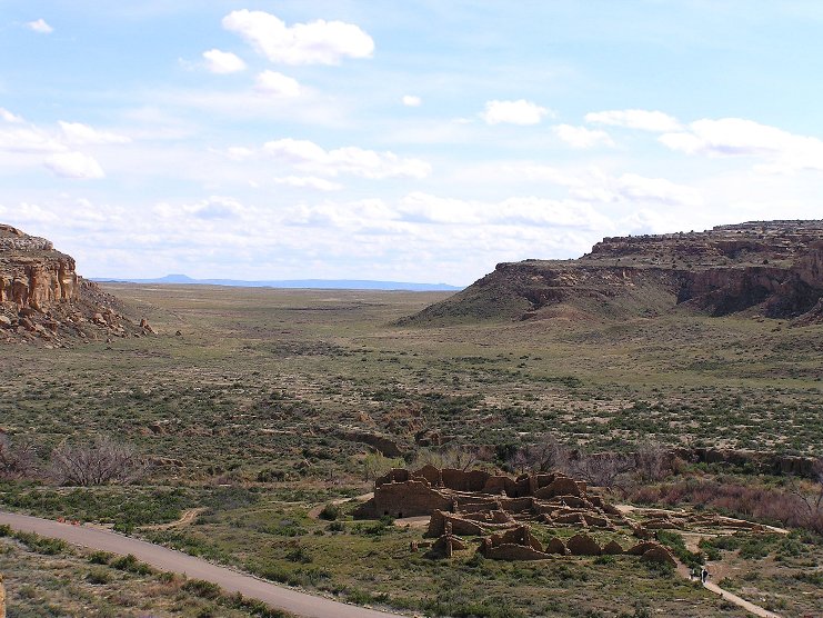 Day 5. 6/16 Saturday. On the way to Chaco Canyon, another UNESCO site. 4 hr from Espanola / Santa Fe. On the way, stopped by Valle Caldera nature preserve (closed), and Jemez State Monument (1 mile before Jemez Spring) on NM 4. Ruins of the prehistoric "Gisewa" village, and the historic San Jose de los Jemez church dated from ~1621. A part can be seen from the road. NM 550 is quite scenic and speedy. County road 7900 and first 3 miles of 7920 is paved, then 13 miles of not-so-good dirt road. Chaco ruins are definitely worth the effort of driving and heat. Huge building complexes, inhabited 850 - 1150 AD. North-South aligned. Some wood beams are still intact. The Una Vida trail next to the visitor center (currently a yurt) can be skipped. Pueblo Bonito, Pueblo del Arroyo and Chetro Ketl are close to each other, very sophisticated. Fun to explorer. Casa Riconada has the largest Kiva. I enjoyed the ranger guided tour at Pueblo Bonito. Some wild rhubarbs added color to the otherwise monotonous dusty brown.
 De-Na-Zin Wilderness is ~1 hour north of Chaco on County Rd 7500 (a much better dirt road than 7950, but with more forks, so should be avoided at night). Cretaceous age Fruitland Formation.
 No established trail. Sandy. Almost no visitors. The only footprints are your own. Easy to get lost, and we did! 20 minutes into the trail, I lost the sight of my father. Ran back to the car, nobody. Want down the trail and looked for him. Nothing. Called 911 ~6:35pm. Signal strength is very weak. Had to call again and again, later to the state police dispatch. The Navajo fire department rescue team came ~half an hour later. The first group of 3 people and a dog lead by Chris, went down to the trail. Later another group of 4 went in to the desert. I went up a small hill, screaming and waving my light blue sweater frantically until sunset. Temperature dropped sharply. More people came in the mean time. Fortunately a helicopter also arrived. Using thermal vision to scan the shallow canyon to no avail, because the stones were still emitting heat. It then lowered itself and used night vision. Tom was the communicator with the chopper. Police patrolman James Rempe seems to be in charge of the operation. They finally spotted dad ~9:10. Chris et all put dad in the helicopter. James later led us back on the highway, made sure that we filled the gas tank. He, San Juan county fire department and county sheriff rescue team are the hero, and where my three thank-you packages were sent later.
Another entrance to the wilderness is the Bisti parking lot on the west side, 2 miles on County Rd 7297 from NM 371. We took 7010 to cross from NM 550 to NM 371. Drove by the west side in dark.
Overnight at Grants, ~60 miles west of Albuquerque.
Day 6. 6/17 Sunday. Terribly windy. NM 53 south of Grants leads to Bandera Ice Cave a half open lava tube. Very small. Porous basalt acts as insulation. A few steps led to a small viewing platform. Visitors are not allowed to go further. Another short trail goes through a lava field to a small crater. In my opinion, this is not worth a stop, let alone the $10 admission.
 El Morro national monument is ~20 minutes further down on #53. A tall sandstone bluff with a reliable water hole, turned graffiti wall for the passing travelers over 400 years.
 One of the oldest is in 1605 by Onate, Santa Fe's founding father. The inscription trail is 0.5 miles wheelchair accessible to the base of the Inscription Rock. It connects to another trail to the top of the bluff (~250 ft, ~1 mile), view of the small Box Canyon on the other side, and a good view of the surrounding landscape, with a small ruin atop called Atsinna. Well worth the short effort. The top sandstone here is Dakota, much lighter color than the otherwise red base.
El Malpais national monument spans between NM 53 and NM 117.
 A zuni-acoma trail traverses the badlands. Only NM 117 (I40 exit 85) provides good viewing opportunity. The first overlook is a must stop: a fine view of the huge lava flow now filled with low scrubby bushes and fissured ground. Could barely stand straight on the sandstone escarpment due to wind. The next stop is the Ventana natural bridge, viewable from the road. There're many lava tubes in the park. Closed when we were there.
Acoma (Sky City) is ~13 miles south of I40. Just follow the numerous signs. Last full tour leaves at 3:30pm (every hour). $20. A half-hour tour is offered at 4:30pm. A bus takes you up to the village atop of a sandstone bluff. Tourists are not allowed to wonder around, except in the visitor center. Even at the edge of the parking lot drew a security guard's warning. Great rock formations in the surrounding tribal land (photography requires a $10 permit). Acoma is also known for it's pottery style.
5 hours later, overnight @Carlsbad, ~40 minutes to the caverns. 25° @9pm! On the way, passed through Artesia, a town that stinks of various chemicals from miles away.
Day 7. 6/18 Monday. Carlsbad Caverns, a UNESCO registered natural site. 35°C, even though it's over 5000 ft high. The caves are big, otherwise nothing special. Minimally lit. Two self guided routes: Big Room and Natural Entrance trail. The Big Room is a must. Aptly called. It's probably the biggest cavern in USA. Natural Entrance trail (closes at 2pm) starts 200m outside of the visitor center, descending via endless steps to the Big Room, for about 800 ft drop. There's a gift shop, restrooms near the Big Room, where the elevator takes visitors up to the visitor center at the parking level. We also took the King's Palace guided tour @10am (one of the many paid tours. However, the discount promised online is not offered at the ticketing counter.) The ranger is way too verbose. A bit of history and a bit of geology. All very basic. About 40 people per group, sitting around and waiting a lot. I got a bit cold (it's 57°F in the cave). King's Palace was the very first to be photographed, which led to the establishment of the park. Unfortunately, the largest cave in the park - Lechuguilla is closed to the public.
 White Sands national monument is the largest gypsum field. 3 hrs west of Carlsbad, near Alamogordo. 250 million year old ocean sediments trapped here in the Tularosa Basin, then evaporated. The dunes are not high. Easy to walk up, preferably in bare feet. It's surreal. Although the air temperature is quite high (close to 30°C), the sand is cool, soft but not too soft. However, wind was blowing the sand, obscuring the sky. The easy 16-mile loop drive has many parking spaces, two large shaded picnic areas equipped with restrooms. The monument is in fact inside a missile range. The very first nuclear device was probably detonated not far from here.
Three Rivers petroglyph site.
 ~30 minutes north of Alamogordo on #54 (a 5 miles paved side road to the east). Piles of rocks with countless drawings on a small hill, overlooking the expanse of farmland with distance low mountains. Wonderful setting. The rock arts here are dense, descriptive, some abstractive. Didn't see a single river, nor anyone guarding the place.
Overnight @Socorro, ~1 hour south of Albuquerque.
Day 8. 4/19 Tuesday. 25°C. Albuquerque old town is charming: leafy plaza, and a lovely looking adobe Church built in 1700s (boring inside). I actually like it more than Santa Fe plaza. The lady at the visitor center said that shopping here is 1/3 of the price as in Santa Fe, which I didn't bother to verify. Lunch at Duran Pharmacy. Another recommendation of Frommer's. Was so-so. Its red chile does have a distinct flavor. It's a bit out of the way. Dining in the plaza would be more pleasant.
Stopped by University of New Mexico on the way to the airport. Mud colored adobe-pretend buildings.
My favorites of this trip: Bandelier, Chaco Canyon, Ghost Ranch, White Sands.