My hiking friend O from Oregon planned this with her friend J, and invited me along, for Dec 28 - Jan 2. I was bored, so jumped on, but with trepidation, and different time frame (to minimize PTO). COVID cases in US are rising rapidly: risk is high. This would be my first flight this year. I brought a big plastic pillow case.
2020.1.31, Thursday. I switched from the blue surgical mask to N95 when I arrived at the airport. I was expecting some COVID screening, but none. Going through TSA was fast, lines at Seatac airport were short. Most people wore face masks. My dayback was flagged because of peanuts and cachews. But it didn't take long for the inspector to let me go. As usual, I was later than most passengers. When I arrived at the gate, pre-boarding already started. The gate was very crowed. The queue to board the plane is as packed as before COVID, i.e. you stand next to each other. The plane was 100% full, including all middle seats. When I checked in yesterday, I was given a chance to sumbit a bid to give up my seat. On top of the full flight, the attendants offered drink/snack for sale. Well, you cannot wear a face covering when drinking/eating.


A long line at the airport waiting for Uber/Lift. So I changed from N95 to the blue surgical mask and walked to my hotel (not the safest due to the speed of cars). After checking in, I walked to O + J's hotel. Definitely holiday scene everywhere, brightly lit, and lively. Once inside the hotel, had to walk through a long stretch of slot machines, to get to a queue waiting for an elevator. An employee was monitoring this. But more than one parties would take the same elevator: simply not enough elevators to keep adequate distance. I was told J went out to gamble. We spent a long time looking for a place to eat (either fully booked for the day or the next available slot is 2 hours later). Eventually decided to order a pizza downstairs. There was a line here too. The restaurants are supposed to be at 25% capacity. Even though they are usually operating at 50%, with 1/3-1/4 restaurants closed, every eatery had a long line. Even to order something to go, we had to wait for our turn. Food is pricy here. Took our pizza to the room, J was back. O brought out a bottle of sparkling wine, we both brought snacks and chocolate. Exchanged presents. J complained of stomach problem, so didn't partake any food or drink. I consulted the hikes they did the previous days, and it was midnight. Some small fireworks here and there. Nothing major.
2021.1.1, Friday.
Headed out to the street, now flooded with people, many holding various sizes of plastic towers of daiquiri, wearing 2021 paper hats. Most wore face mask.

Lots of police. They blocked Las Vegas Blvd from motor traffic, so you could walk on the road (except for the center 2 lanes). All the trash cans were full.


Once awhile a pair of girls scantly dressed with large feathers on their back offered to pose photos with you. On our way back, the cleaning vehicles were already swiping the streets.
Didn't need to get up early. Sent messages and emails wishing people a happy new year. Around lunch time, I went to meet with O again. She told me that J had changed her flight and flew home already. We walked towards downtown. The strip looks prettier at night with all the lights.

Again, all the drink/food places had a line. A line of people waiting to buy
Mechelada from a car.

This souvenir store has a large selection of Trump trinckets, including toilet brush. The more closer to downtown, the less expensive, and more residential. Some large tract of dusty land vacant.

We walked all the way to the Vegas sign.
Saw this poster for Jesus. On our way back, saw quite a few people carrying loud speakers demanding all to repent. Went to see flamingoes, but was told they were in a checkup. The streets were no longer blocked. So had to walk up and down pedestrain bridges. I got rather sleepy, and decided to go back to my hotel and rest. Made a few phone calls, and took a nap.


Ate some food before meeting O. We walked to Bellagio for the hourly fountain show, and to Mirage for the hourly volcano show. Both only ~5 minutes, but free fun. I especially like the fountain show.In between 8 and 9pm, we walked inside of Venetian (across the street from Mirage).
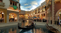
I really liked their indoor shops, which has a painted blue ceiling, even enough water for gondolar to glide in. Looks like outdoors with permanent good weather. I also like the front desk of Bellagio (the glass panel on the ceiling) and the chocolate fountain in one of its patisseries.
2021.1.2, Saturday. I watched the moview "Ford vs Ferrari" a week or 2 ago, which got me interested in
Carroll Shelby's race car manufacture.
 Shelby.com
 advertises a daily 10:30am guided tour, and a Saturday 7-10am
coffee and car gathering of car enthusiats. After picking up a rental car, and some juice, I arrived at
Shelby Heritage Center a little before 10am. Indeed, I saw a bunch of powerful cars out in the parking lot, and soon they drove off in an orderly procession.
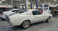
I asked the permission from a guy there to take a photo of the factory (the door was wide open). He let me into the factory and showed me the most expensive car they have now, on loan from the owner: this vintage
Mustang GT-500, estimate of $2.4M.
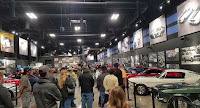
Before the tour started, my friend O arrived. She even won a cup from the guide. I didn't quite like the small tour. The guide told us his story of growing up in Alabama, the army, and working in Jack Danials before coming here. With a face mask, it was hard to hear everything he said. He tried to make it more entertaining, assigning the tourists to impersonate a figure in the story. After the tour, I dropped O. at the airport for her return flight.
Now I start my hiking portion of this trip. First destination:
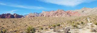
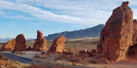
Red Rock Canyon. It's only half an hour away. I didn't make a researvation for a timed entrance, because O told me they didn't need a reservation. They just paid $2 reservation fee at the gate when they entered (+ park's day use is $15 or free if you have America the Beautiful pass). When I checked at recreation.gov last night, all the slots were wide open. I went for an easy hike at the first pullout before entering the scenic drive, in Calico Basin. Quite a few people here. Fairly easy trail. Nice view. Saw many climbers practicing here. I did a loop. Possible to continue much longer.

Next, I drove to the gate (~2:30pm). A long line for cars without reservation. We were sent away. No signal here. Had to drive out ~3-4 miles make a reservation on my phone. 3pm wasn't available. So booked for 4pm entrance (the last one of the day). No wonder earlier I saw many cars parked on the road seemingly for no reason. I went back to the gate, they told me that I couldn't get in until 3:30pm. I tried to time it for 3:30 twice, and one employee finally waved me in at 3:29pm.

Sun sets around 4:30 here, so I didn't have much time. Checked out a bit at Calico Hills (very colorful). Went to Keystone Thurst trail to see the geological feature:
Keystone Thrust. Not sure what I was seeing.

Got back to the parking lot shortly after 5pm, already very dark. Las Vegas was shining in the distance.
The scenic drive is one way anti-clockwise. I think it should be going in reverse, because currently the sun shines on the later part of the loop in the morning, and early part of the loop in the afternoon. O recommended Icebox Canyon. She said it was a fun scramble. Well, next time.
On the drive back, stopped at Trader Joe's for some grocery. Drove to a different hotel with a kitchnette for the next 3 nights. Made a couple of phone calls, and prepared for a real hike tomorrow.
 2021.1.3
, Sunday. My alarm clock was set at 6:20am. I wanted to arrive at TH by 8am (50+ min drive), because O told me that
Griffith Peak was not easy, and it requires a full day. Parked at Mount Charleston Lodge. A few people were heading to their restaurant.

The gate to the trails is locked. Not sure why. So TH parking is not reachable. Already plenty snow here (elevation ~7600'). Air was crispy, still above freezing. Followed the obvious boot track around the gate. It was confusing at first, due to multiple trails near the TH. But I was on the right track pretty soon.
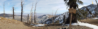
The first half was fairly easy. After the first section of zigzag finished, ~9100', the snow got quite deep. The next zigzag section, the boot track was cutting the trail. Because I didn't want to posthole, I tried to stay on the existing track, which was steep at times. Without any traction device, nor hiking poles, it was not easy. When I reached the ridge (~10700'), it was already noon! Here you'll see trail junction sign of Charleston to the west and Griffith to the east. No more boot tracks. Windy. Burnt trees. Around this time, I saw one guy was coming up, 10-15 minutes behind me.
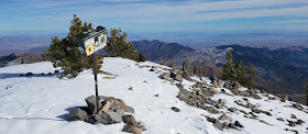

Followed the ridge, dipping down a bit to a saddle, and then up, breaking trail, and fighting the wind. Finally at 1pm, I made to Griffith Peak (
11053'). The view is good, not sure if it's worth the effort. Cannot compare to a view on top of any mountain at Snoqualmie Pass with half the elevation. No place to hide from the wind, I retreated to the saddle, ate my lunch, and took my boots off hoping they'd dry up a bit in the sun. I don't see another person until back at TH. Going down, some of my track was already covered by snow. I got back out at a different spot on the road. ~4pm. The lodge's restaurant was all booked for the day, so couldn't go in.
Pink sky as I drove back to Vegas. Stopped by Wholefoods for some more grocery.
 2021.1.4
, Monday. I set my alarm even earlier. Left the hotel in dark. I was hoping to catch sunrise in
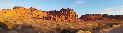
Valley of Fire. Vegas, even though south of Seattle, being in the same timezone, but more east, the sun rises earlier here, and sets about the same time.
At the west entrance, I used the toilet (running water) and stuffed $10 in an evelope. Chilly at 7am. The Valley of Fire is, in a valley. Morning sun lit the south facing rocks nicely, but no real sunrise. I headed to White Dome Drive, still in shade. First stop, Mouse Tank trail for petroglyph. Quite a few rock faces have drawings. Otherwise, a jumbo of red rocks. The short trail ends at Mouse Tank, which has seasonal water. Dry now. There're picnic tables under a roof on the opposite side of the road.

Next, Rainbow Vista. A short walk up a butte for this view. Otherwise, a sandy trail, ends at a drop down to Fire Canyon. Everywhere, a sign warning of extreme heat. I started to see other tourists.

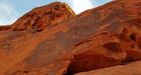
The rest of the drive (all paved) is very scenic. Saw 3 big horn sheep right by the road. Not sure what they eat here. There are small designated pullouts for parking. You can stop and start scrambling. Every direction beckons you to explore. The boulders here have layered patterns like waves.

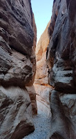
The end of the road is White Domes loop trail. Very large parking lot. Restroom and picnic tables under a roof. It's a short loop, passing some old movie set. But plenty room to explore further. Very pretty. The official trail also passes a narrow slot.

At the other side, another trail (Prospect Trail) goes all the way back to the main Valley of Fire Hwy. I highly recommend the short loop. Here, I took too many photos. Also had my lunch scrambled up a big rock. It wasn't noon yet. It was getting warm.


Fire Wave, has the most prominent waves. Large parking lots on both side of the road. Indeed it was popular. Plenty room to roam, but the main attraction are these large slabs with wavy lines, at the end of the trail. In fact, I think it's better to come here from Pastal Canyon trailhead, which is a small pullout, so you can avoid the crowd. I took many photos, sometimes have to wait for people to leave. I was sweating. Strip down to T-shirt.


Pastel (Pink) Canyon trail is short, about half a mile south of the large parking lot of Fire Wave. Many wavy lines here too, off the trail. It's easy to go from here to the center of Fire Wave.
I saw a couple of cars parked at the locked gate in front of the a dirt road right at the bend (the north most) of the White Domes road. Didn't explore that.
Drove the paved side road to Fire Canyon overlook. A big parking lot. Jumbos of rocks. Didn't hike very far. Saw many sheep droppings.
Went to the visitor center at the begining of White Domes Road, inquiring for a vintage point for sunset. I get what I expected: there's no good sunset vantage point, because the valley is lower than surrounding hills. Either outside of the park, or around the road bend, where the space is more open. There's a small empty theatre showing a video, and display of the local historical artifacts. Proper restroom and drinking fountain. Balance Rock trail is here next to the visitor center.
I spent the rest of day light making just photo stops along Valley of Fire Hwy east of the visitor center. I cannot count 7 pillars at the Seven Sisters rest stop. Did see a wedding shoot here behind a sign for wedding only.

3 historic cabins were built with Valley of Fire sandstone by the Civilian Conservation Corps (CCC) in the 1930s for travelers. Now a rest area.

Elephant Rock is next to the east entrance. You park here, and hike back. A short loop. Not all that interesting. By now, 4pm, the sun was already quite low. Soon it disappeared behind southern hills.
On the drive out, saw some colorful clouds. Not much of a sunset. It's 1:20 hr drive back to Las Vegas. Filled gas. Checked in my flight. Retired early.
2021.1.5 Tuesday. Nothing interesting today. Returned the car, and flew home. Again, full flight. I wore N95 as soon as I arrived at the airport. It was raining when we landed in Seattle.
Summary:
- Flying is too crowded. But cheap and changeable without penalty.
- Las Vegas downtown and Strip is crowded, so are all the casinos. Eating is a hassel due to the reduced capscity. But staying in the outskirt is easy and safe.
- Desert is good in winter (always sunny).
- I brought too much food. Only consumed about half.
- My rental car is pre-paid at Priceline, very cheap. Hertz charged me again after I returned the car. Always check your charges after your trip ends!
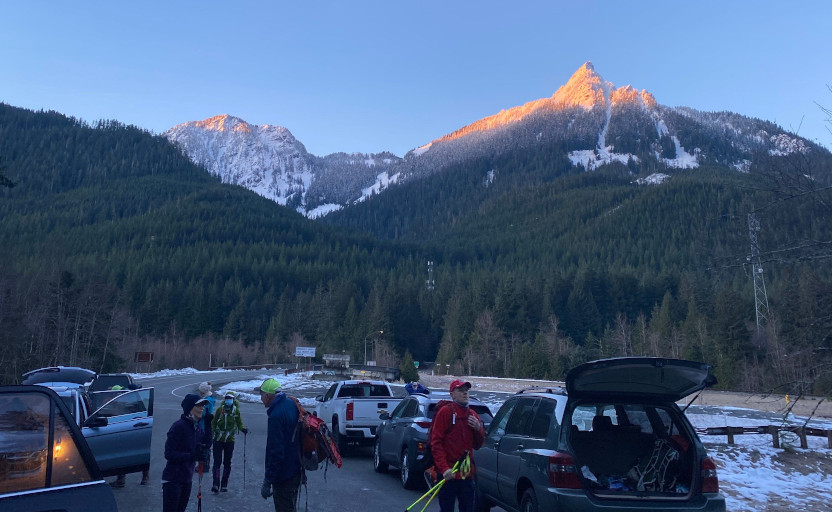
 I was picked up by I-5 exit ~7:10am. After a coffee stop in Arlington. We arrived at the end of FSR 1890 (further than the road end on Google map or CalTopo) before this bridge. There were 5 other cars, and they were just gearing up. What prompted me to hike this today is T's group would be ahead of us.

 Finally at around 3400', on the (not well defined) eastern ridge towards Higgins, we hit snow. Crusty, patchy, soon it was solid. We put on micro-spikes. The slope isn't steep here. All the while in the woods, with glimpse of broken views through the trees. ~4300', we reached a "top", a flat ridge out of the trees. Here you can see the Round Mountain ahead (north), and Higgins to your left (west). Also, we caught up T's group as they were going down, one at a time, slowly.
 Here, a very steep but short section of down climb. We took a long snack break here waiting for T's group to finish. Then, used ice-axe to down climb, also one at a time. The snow is good for holding my feet. Now, in the woods again. Losing a bit of elevation before slowly going up again. All along, an obvious and narrow ridge. Before the slope gets steep, I stashed snowshoes and one pole by a tree, stashed the other pole in my pack. I changed into crampons. The rest looks too steep for me to use snowshoes. Besides, we were not post-holing much. On snow, we could easily follow the footprints of T's group. The climb is quite steep, but the snow wasn't too hard. At ~1/3 way up, in front of a steep rock (right below where this photo was taken), we met a lady sitting by some trees. She quit and was waiting for her group. V decided to wait with her. He wasn't comfortable going up in micro-spikes. The view here to the south is already great.
 I followed the footprints, detoured around the rock. Yes, a bit tricky, because both sides were steep drops, but not too bad. I didn't feel any real danger, because the snow was solid enough to hold my feet. Of course, ice-axe helps. The slope gets easier the top 1/3. The very top (~5320') is befitting the name: round. ~1:20pm. I was surprised to see about 10 people there. Another group took a different route, not sure from where. I walked around the flat summit, didn't see any footprints going down anywhere expect for where I walked up. The 360°view is splendid. I can see Rainier to the south, Olympic mountains to the west. Baker to the north, North Cascades to the east. However, all the peaks are a bit far. I chatted with T for a bit. The lady down below is his wife. He is against carpool due to Covid-19, emphasizing double mask and keeping distance. Most of his group didnt use crampons. The other group, seems all on crampons. After everyone left, I had the summit to myself. It was lovely. Very little wind.