To reduce weight, I removed tent footprint + 1 stake, guylines, pad bag. Changed to a lighter sleeping bag. I should have taken less food and clothes. I didn't have any appetite during the day (too warm), and I was able to wash my T-shirt and socks - they dried quickly. As usual for a difficult hike, I took 2 phones, both loaded with the aforementioned GPS map and trip report, plus backup battery. O has no GPS, zero tent stake (camping on gravel), same T-shirt and same pair of socks for 3 days! Really minimize the weight. She carries less than 1L of water. I carry 1.5-2L in such temperature. She took sandals and 2nd pair of socks for the camp, because her hiking shoes are worn out with holes. I shall look into breathable (non-waterproof) hiking shoes, for dry trails in the future.
 7/25, Saturday, pleasant, sunny. Hwy 20 is rerouted around Marblemount. So had to drive west (~1 mile) to the Wilderness Info Center. We arrived shortly before 10am. A lot of folks hanging around the building with only one window open. A blue canopy tent outside with a ranger and a table. Another ranger holding a clipboard walking around. We didn't know what's going on. Should have taken a ticket before using the restroom. There's a queue! I asked one guy sitting in the sun. He had waited for 2.5 hours! His number was coming up next (there's a red LED showing the number being served). Our number was 30 later! I ate my sandwich, took out my Kindle and stood in some moving shade. O packed and then waited near the window. People came and went. We got our permit at 11:30. Half of the numbers called had no response. Apparently, people gave up. Terror Basin is not popular, so we were sure that we could get a permit, just need to wait for our turn. O also inquired about permit availability in neighboring areas next week, how many permit already issued for Terror Basin. We were told one. I liked that.
Drove to Goodell Group Camp east of Goodell Creek. There's a sign of camp closure at the beginning of the spur road. So we didn't drive up. The road looks a bit rough at the turn, but better later. We parked along the main road in a pullout next to another car. Doused myself with bug spray, and left the bottle in the car. Walked at least 1 mile to TH. There, we saw ~6 cars! The camp area is a few steps further, of course now empty. I didn't see water source here. The narrow trail starts off next to the parking lot. Elevation 600'.
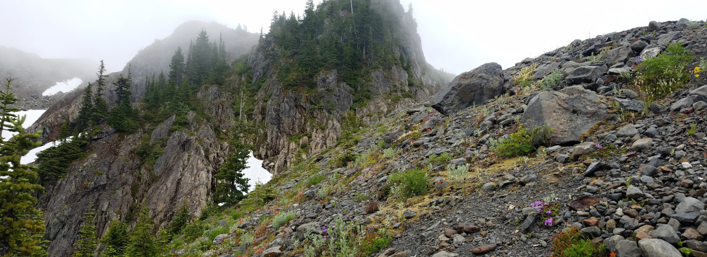
 The first couple of miles is like an obstacle course. A bit overgrown, at least I could still see my feet. Otherwise, I'd be tripped over a hundred times by down branches and rocks in the middle of the trail. Ripe thimble-berry. Saw one grouse. Then the trail reassembles a road apart from fallen logs: wide and flat. Passed two creek crossings. The 2nd one has a nice shady side where I refilled water. Soon after, a round area with a big cairn in the middle, and a small cairn right next to the climbing route to the right. Mosquitoes kept us walking non-stop. No bugs at creek crossing.
 Here, after 4.5 miles and only 1000' gain, the ascent begins, in earnest. Picking huckleberries (both purple and orange) gives some reprise. Not very ripe yet. Cannot stop for long, due to bugs. Temperature was rising, but luckily, the trail is mostly in the woods. When climbing over one big log, my water bottle fell out, and rolled downhill. I brought only one bottle, so had to scramble down to fetch it. Found another water bottle half buried in the dirt near mine. By then, no more mosquitoes. Very dry slope. After gaining about 2000', the slope eases a bit traversing north. Then, the trail gets even steeper. At times, had to grab on roots to pull myself up. We lost the trail briefly. This goes on for ~1000'.
 4 hours after the TH, we finally emerged from trees. Melting snow and wet trail, mosquitoes. The black lichen on rocks is slippery. Still gaining elevation while traversing the heather slope. The 2nd creek crossing here is the main one. Need to follow it up, hopping back and forth between the two banks. Pay attention to small cairns. Soon we lost the trail, and found it again, and lost it again. I was getting tired, but this area is too buggy to camp, at least now. Sun was setting, the view is very good here. You could see the Picket Range, and Baker behind them.
 By the time we reach the "notch", it was already 9pm. Quarter moon hung high in the sky. The slope that worried me was now all snow. Put on crampons and ice axe. I also put on my helmet, for the steepness makes me uncomfortable without it.
  It was still light enough. We could see where we were going and a couple of tents.
 In this photo taken the next afternoon, I drew the route going down to the camp. As we were pitching our tents, we saw some headlamps moving in the far side: some climbers were just coming back. Three guys didn't have tents, just bivy, or just sleeping bag. I couldn't tell in the dark. I didn't cook dinner, ate a couple of bars, and get to bed. By then, it was already ~11pm. Moon had set, the night sky was brilliant. You can see the silhouette of all the peaks around us. Wish I knew how to take a long exposure photo. Of course, there's no way I'd haul a real camera here. O didn't bother to put up her tent fly. The low maybe ~45°F. I didn't sleep very well. Woke up many times.
Today: 31K steps, ~8-9 miles, ~6000 'up, ~1000' down. 9 hours on the trail.
7/26, Sunday. 88°F in Seattle.

 I got up before 5:30am, and scrambled up the scree pile south of the camp area, to see sunrise. There are purple penstemon, white saxifage among the rocks. Now I could see at least 5 other tents down at the camp, and 2 further on along the climbing route. When I got down for breakfast, most folks in the area were up. Already, 2 groups heading to the climb, and one party of 3 (with ropes) heading back out. Someone had chewed my sandwich!
 At 7am, we were geared up and started hiking. First more or less flat, passing another smaller gravel area with the 2 tents, and losing some elevation before going up. View is expansive all along. More snow than last year. So this is a higher route than the GPS track I saved. Just followed footprints on the snow. A few short but scary snow bridges to cross. In such warm weather, they would probably collapse in a week.
  The little green lake down, where the summer route goes by, was still entirely covered with snow. The Azure Lake was mostly covered by what looked like thin ice. Had to go over some rocks with crampons, too lazy to take them off, because those are short. Small waterfalls sliding over rock faces everywhere.
  As we gained elevation, we could see Rainier. Then, we were at the bottom of the steep snow to the "col" between McMillan and Inspiration. The first group of 6 were going down slowly one by one, as we were tredging up. Two of them said this is the most difficult section, which I agreed afterwards, when down climbing.
 Stashed crampons and ice axe at the "col". Now it's a "class 3+" rock scramble along the westen ridge of McMillan. Met a couple coming down the ridge. View is stupendous. So many peaks that I cannot name.
  There were boot tracks in both the lower and upper section. The middle part is the steepest. Mostly, you follow your instinct to pick where to go. Be careful, many rocks here are not stable. Occasionally, saw Jacob's ladder, fuchsia phlox (?), and this unknown (to me) yellow aster.
 Finally I was on the stack of big brown slabs of rock that marked the summit. There is a registry, but O said she couldn't open it. Not enough space to relax. We retraced a few steps to a shade north of some boulders, and had lunch. O got a bit cold in the shade, as she has waited for me for awhile already. She started down. I took my time to saver my reward. Finished my sandwich before heading down.
Going down a steep slope is always more treaturous. I don't know how scramble is classified. At least now I konw that I don't wish to go down anything more than "3+". It probably took me longer than coming up. Resaddled into crampons at the "col". Down-climbing the snow field is also a bit scary. Especially now, with the afternoon heat, at least twice, rocks from Inspiration crashed down on to the slope not far from us. I went down facing the slope, jamming the pick and my fingers into the snow on each step. It took awhile until I got to the traverse without any incidentk. At one point during the traverse, I slipped and slid downhill. Even though I know how self-arrest should be done, at that moment, I wasn't able to do it. Thankfully with some kicking and screaming, my slip came to a halt. Another time, when I slipped, it was the ice axe holding me up, so I didn't slide down. Need to be careful all the time.
 Back to the camp ~3:40pm. Only our two tents left. It's perfect. I washed my shirts and socks. Hung them on bushes to dry. My nose bled. Too dry and warm here. Hid behind the only big rock for some shade (actually it was cool enough I had to put on both my fleece and a shell), and read my Kindle. A hummingbird darted about us. Had a nap, and then an early dinner. Rearranged my pack for tomorrow and filled the water. Scrambled up the rock pile again for sunset ~9pm. Had a blissful time.
I slept better tonight. Woke up ~ midnight. The moon had set. Another sky of brilliant stars.
Today: 20K steps, ~6-7 miles, ~3000' up and down, 8.5 hours on the trail.
7/27, Monday 93°F in Seattle. Alarm at 5am. Scrambled up the rock pile for sun rise again - better than sunset at this angle. Packed, and started hiking out at 7am. The snow field to the "notch" is harder this time. We kept on crampons going down the other side. Saw 2 marmots jogging across the snow. Then we packed away crampons. But had to put them on again on another snow field. Going back, we were able to follow the trail all the way. Arrived at TH at 14:05. Still 4 cars there! Maybe they are doing Picket Traverse? Or Inspiration Traverse?
Our lonely car, thankfully in the shade, read 94° at 14:30. I wasn't too happy walking the road for 20 minutes, mostly in the sun. But saw a big broken log across the road. Don't remember if it was there when we came in. We drove to Goodell Picnic Are (boat launch but ramp blocked by parking dividers) to wash and cool down. There's a picnic table by the ramp. Skagit River was running fast. I was happy to stay ashore, just walked bare feet into the water to wash and washed my t-shirt. Water was cold. A nice color. Relaxed by the tree. Warm breeze on my wet shirt felt cool. I shared a bag of smoked sausage (which I hauled up to the camp). We liked the salt. The temperature by the water was comfortable, almost no bugs.
I drove back at ~15:50. Got home shortly after 6pm. Fairly smooth on the road. Many cars, but no traffic. The neighborhood homeless lady came upon us when she saw me giving cash (for the gas money) to O. That was scary. O drove on to Oregon.
Today: 29K steps. 7 hours on the trail.