Day 6, 9/17, Tues. Mostly cloudy. Rain at times with sun breaks. After dropping off my partner at Dawson Airport, ate lunch, filled some coffee, I drove to Whitehorse, about 5.5 hour away.
Filled gas at Stewart Crossing CA$1.52/L. There isn't even a washroom to use :( Could see the forest fire to the east as I drove south.
Pelly Crossing is a real town, however small it is. There's a post office. Gas at CA$1.51/L. Saw a fox or small wolf in mid road. Then, a big porcupine slowly crossing the road.
Klondike Highway from Stewart Crossing to Carmacks is along the eastern edge of
Beringia. There's a pullout with a nice display by the road. There're also multiple pullouts to view Yukon River.

Didn't walk all the way down the stairs at
Five Finger Rapids. Nice panels along the over-engineered wooden stairs. Large parking area. From the top, couldn't tell the 5 fingers. Probably less from up close.

I stopped at
Carmacks to use the washroom in the general store (downstairs). The visitor center was boarded up for the season. Gas here was CA$1.52/L. The hotel has free public wifi. The town has built a nice walkway along the river, fitted with benches. There was a 5 min wait shortly south of Carmacks due to construction.

The fall color got better as I drove closer to
Whitehorse. More and more leaves were still on the trees. I started to see homes around the huge Fox Lake, almost an hour north of Whitehorse. Bought some grocery in Whitehorse, a real metropolis, fitted with regular Canadian chains like Save-on, Super Store, as well as Walmart (no fresh food). Walked a bit at the nicely manicured waterfront. Stopped at the visitor center (8-8) for Kluane map and washroom. The wifi was turned off when I arrived (15 min before it closes). Gas in town was CA$1.42/L.
From here, I turned west on
Alaska Highway towards
Kluane.
 Day 7, 9/18
 Wed. 8am 3°C. Stopped by
Takhini River viewpoint. Saw some campers and white swans.

Elks on road, just east of the construction detour. It's about an hour to Haines Junction, the base for Kluane National Park.
At the
Haines Junction visitor center (8-8 daily), I inquired about hiking and 1 night backpacking options (100% rain is the forecast for Friday) at
Kluane National Park desk (9-5, closes after Sunday 9/22 for 2019). The young man there is very patient. Gave me some suggestions and printouts based on my interest and limitation (high elevation, no creek crossing above knee). I ended up these 3 day hikes:
King's Throne to peak,
Auriol Trail and
Sheep Creek to potential
Bullion Plateau, so didn't need to get a permit. The German ahead of me took a long time for his 2 night permit on a river trail and deposit for a bear canister. The visitor center has a joint culture center (8:30-6, closes on Sundays). There are 2 drinking water dispensers, which I filled my water bottles. Both have clean washrooms. Gas in town is CA$1.48/L.
Driving south to Kings Throne TH, more and more cloudy, then rained lightly. I decided to hike it the next day, which was supposed to be sunny.


Hiked the very short
Rock Glacier trail. Light rain mixed with sunshine. A well made, if not over-engineered trail with boardwalks, stairs, and stone steps. Good view. Rainbow!


Million Dollar Yukon Campground has a short tail hugs a narrow channel where water tumbles down. Again, over engineered wood walkway. There are 2 cooking shelters, free firewood, outhouses. No water pipe!
More and more clouds. Wider and redder terrain. At
Chilkat Pass, I couldn't even see much. Wind also was getting stronger (gust at 70km/hr). I abandoned hiking altogether, and drove all the way to
Haines.


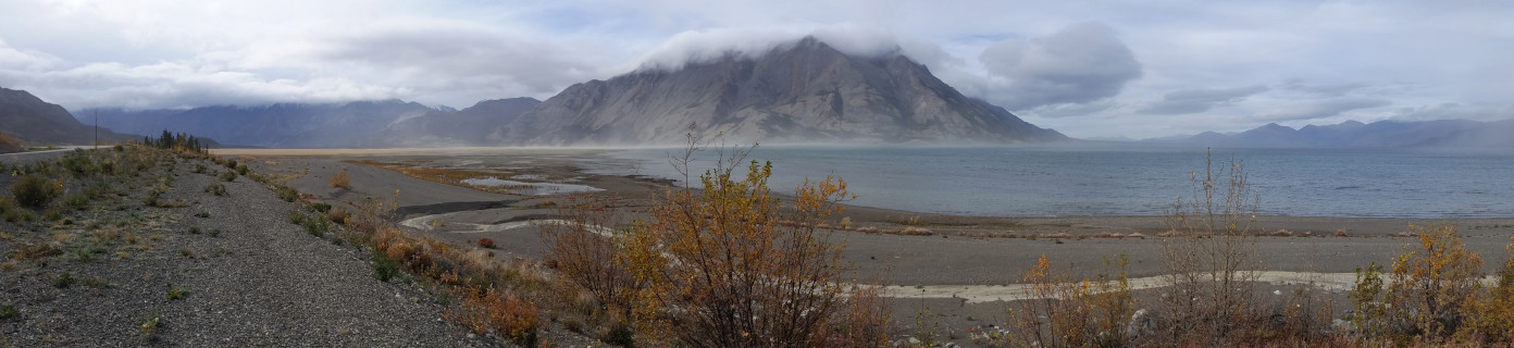
Border crossing is a breeze. It's on the green side: wetter, more glaciers, more trees. The road goes along
Chilkat River, which is extremely scenic, despite of the low clouds. As the river delta gets wider, the wind becomes stronger. At times, I was afraid that my car would be blown over into the river.


I, of course, didn't do my homework. I've marked
Chilkat Bald Eagle Preserve on my map. Wasn't aware that eagles wouldn't congregate here for at least another month. I did see one, who's probably a resident. There are many road side pullouts, some equipped with outhouses and displays. One nice boardwalk among trees. Chilkat River along the Haines Highway between miles 18 and 24 are the main area for eagle watchers and considered critical habitat in the preserve. Bald eagles are attracted to the spawned-out salmon in late fall and winter, when the water here is warmer than surrounding area. This
natural phenomena is called an "alluvial fan reservoir". The Tsirku fan, which is a fan-shaped accumulation of gravel, rock, sand, and glacial debris, at the confluence of the Tsirku, Kleheni, and Chilkat Rivers acts as a large water reservoir during the warmer spring, summer. The alluvial fan receives water faster than it can flow out, creating a huge reservoir. When winter arrives, water in this large reservoir remains from 10 to 20 degrees (F) above surrounding water temperatures. This warmer water "percolates" into the Chilkat River and keeps it from freezing.
Haines is a proper town.
Alaska Ferry terminal is 5 miles out of the town. The library takes donation before giving out their wifi password. Visitor Center doesn't have wifi. I inquired about the weather, was told it would be the same the next day. It was raining lightly, windy. I filled gas at US$3.9/G (similar to Haines Junction).

On the way back to Canada, the clouds parted a little bit, so I got to see something. The scenery at Three Guardsmen (near the pass) is superb. Lots of low lying huckleberries. I walked up a small butte for this photo. Very windy.
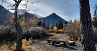
Back at Million Dollar Falls camp, already dark. Only 3-4 campers. Windy. Instead of cooking on a table in the open-sided cooking shelter, I had to cook on the floor at the corner to minimize the wind.
Day 8, 9/19, Thursday. 6am 8°C. Drove ~55 miles, least in the week. Clouds gave away to sun. Windy, gust to 70kmh.

Cooked breakfast at Kathleen Lake day use area. Drinking water in the camping area. Wheelchair accessible outhouse. The cooking shelter is fully enclosed. Decorated ceiling, 3 large tables, 2 doors. Big windows overlooking the lake. I chatted with the 2 retired guys who were cooking breakfast. They slept in the shelter. They were biking from Skagway to Haines, and came and will leave by ferry from Juneau. A 400 mile scenic route.
 King's Throne
. First 2Km is leveled, in the trees. Saw 3
spruce grouse right on trail, one with red eyelids. The trail then heads up (well marked), soon breaks out of trees and onto a scree field. Zigzag was fashioned out of the rocks. The higher I went, the windier it got. After a short break hiding under a shivering willow, I continued left on to the ridge towards
Kings Throne Peak. Soon I had to sit down to steady myself so not to be blown off the mountain. The gust was constant. I waited a couple of times, eventually gave up, and hiked down. Saw the same 3 grouse. 8:38-11:43. 15k steps.
 Auriol Trail
 starts in a nice meadow with the view of the destination. Then it goes into trees. At 2Km, I took the right fork for a counter-clockwise loop. It had two so-so signed viewpoints along the way, one of those looks out to the town of Haines Junction. Once out of the trees, color was excellent. At 8.2Km mark, it's the highest of the established trail. Saw about a dozen people on my way here.

About here, there's a spur trail that scrambles up to a nice log seat. Very good view here.


Back down to the trail, I followed a creek bed going up. Not steep, wide sloping meadows with tons of crowberry, huckleberry (a bit dried up) and low bush cranberry. No more trail, just checking my downloaded GPS map from time to time. Better view of the mountains.

Eventually I made to a low ridge which I could see the northern part of the mountains and Alaska Highway west. I turned around at 4pm so I could finish the hike and get to the visitor center well before it closed.
Completing the loop. Nice campground in the trees, some have good view. A short distance later, saw a lot of
Yellow Dryas's fluffy seedpod dancing in the breeze by the creek. Then there's a small lake.
12:38-18:32. 26k steps, 1 spruce grouse. 3 pink flowers, maybe purple mountain saxifage.
Went to the visitor center to book a room in town, so I could take a shower.
 Day 9, 9/20
, Friday. Drove 230 miles. Light rain when I got up. Went to the visitor center to checkout all the exhibit, and harassed the employees there about plants. They are all very patient, looking through field guides for me. Here's something I learned:
- During WWII, 30000 soldiers and civilians pushed the 1700 miles Alaska Highway through Yukon in just 9 months.
- In 1943, Canada created the Kluane Game Sanctuary and expelled Dän from their homes. No shooting, hunting or trapping. Fishing permitted.
Bull moose           550 kg (1215 lb)
Sow grizzly          125 kg ( 275 lb)
Dall sheep ram        90 kg ( 200 lb)
Wolf, male            45 kg ( 100 lb)
Lynx                  14 kg (  30 lb)
Golden eagle, female 4.5 kg (  10 lb)
Newborn grizzly      450  g (   1 lb)
Pika                 154  g ( 5.5 oz)

Finally, the rain tapered off, mountains shifting in and out of still thick clouds. I drove off ~2:10pm, on Alaska Highway towards Tok, AK. Two swans in a pond by the highway. A fox or wolf ran over the road.

Scenery around Kluane Lake is superb. The lake is huge. Its southern end is marshy. 3 sheep on a mountain south of bridge. Pulled into the visitor center (now closed for the season). 40+ sheep south of bridge on Sheep Mountain. 20+ on the hill west of it. Very windy.


I gave up hiking the Sheep Creek trail.

Walked the short
Soldier's Summit. The trailhead sign doesn’t have the trail map or description. I went up the hill, the road forks. Left is a logging road, with interpretive signs, the official trail. The right has obvious tracks over some boulder field. I found a couple of blooming purple and yellow flowers. Two kinds of sage.

Didn't make many stops later. The best view of is at the bridge over
Donjek River.
I arrived at
Beaver Creek's Yukon visitor center ~7:25pm, to use the washroom. The lady there also gave me a mileage guide to Tok. Gas in town was CA$1.56/L. This is the west most town in Canada, a real town with police station, post office, and an airport. St Elias mountain range graces the southern sky near the town.


Canadian Customs is just 1 mile north of the town. But US customs is 20 miles farther. This
border crossing is open 24hrs daily. Just before the US checkpoint, there's this large roadside parking at the real border, where you can stand one foot each in two countries.

Panels of Yukon and Alaska map and nearby attractions, as well as about the
141st Meridian and its survey.
 9/28, Saturday. Cloudy. Very lucky this weekend that I got a ride just one block from my home. Met Jai, this event's host at 7am in Lynnwood. When we arrived at Yellow Aster Butte (7.5 mile RT, 2550'EG) ~9:30, there was already a line of cars. Snow on trees. Lots of people and dogs. Saw a couple of pink penstemon earlier on trail. Later some purple aster. Still some huckleberry to pick. Frosty! Instead of fall color, we landed in a winter wonderland. It even snowed a bit. Snow was too bright, all the other colors were compromised. Very pretty.
 The camping area, where all the tarns are, looked very cold. It was also quite windy today, as soon as we left the trees, which is quite early on. I had to put away my umbrella. No hiding place for bio break: too many hikers on the trail. Surprised to see quite a few people with large backpacks.
 Going up the butte itself was a bit slippery. There was a traffic jam on 2 short steep sections. I wore micro spikes, so fairly easy going up and down. Most folks were not prepared for the early winter here. I saw one guy in shorts and sandals, bare feet! At least he put on socks coming down.
 Twin Lakes are ~1000' higher, so a lot of snow. Quite pretty. Established tent pads, picnic tables. Saw two tents on the strip between the 2 lakes, somewhat exposed. A dozen cars. A little hail. Cold. I put on a down vest. Repacked, and we hiked up Winchester Mountain. I hoped to sleep inside the lookout, so didn't take my tent. If the lookout was full, I planned to hike down and camp here, at the lakes, assuming it'd be a couple of degrees higher than the summit, which is 1300' higher.
 The trail is well made. 1.7 mile is easy. When I arrived at the lookout, there were already 2 parties, 5 people + 2 dogs settled in. Jai decided to camp outside. He brought a 0°F bag. Soon 2 more people showed up. We managed to squeeze 9 people + 2 dogs in the small room, two sleeping halfway under the table. With this many warm body, it's surprising how cold it was inside. The snow dragged in by the door became sold ice on the floor.
 We were lucky that the clouds parted a bit, and the sun was setting under the clouds. One of the best sunset I ever witnessed. Everyone got out of the cabin to stare at the glowing scenery.
 9/29, Sunday. No sunrise. Light snow. Took awhile to pack up Jai's tent. His stakes were frozen with the rocks he used to anchor. Cooked hot water to pour on them. Still one was stuck. Hiking down was straight forward. Less visibility than yesterday. It was snowing.
 Our original plan for Sunday is Goat Mountain nearby. Considering the weather, we drove back out. As the elevation lowered, we left winter, and returned to autumn. Took Excelsior Pass trail. Starting elevation is 1800'. We filled water at this cascade, about a mile in. No more water until near the pass.
 The 4 miles in the woods is a bit boring. Finally the trail breaks out into a nice meadow, filled with huckleberry. Great fall color. Little streams. Snow and muddy at times. The pass is beautiful. A bit windy. Met more hikers coming from Damfino Lake. We walked west up a small butte, before returning. 3500' and 4.9 miles one way. Another good workout. I wish the weather were better and I had more time to explore, maybe walk all the way to Welcome Pass. There are trails going all 4 directions from the pass.