2/10, Saturday. Forecast is mostly sunny with wind of 10 miles/hr at the summit. Cannot hope for a better day for the climb.
Meeting time is 5am. I had to stay overnight at my office in order to make that time. The problem of staying late at work, is that I ended up working, and didn't realized the time until around mid-night. Short, but I slept okay. There were 9 of us. Problem with a large group is slow going. We made 3 stops (first stop is to pick up 2 ladies). Didn't start hiking until 7:40.

The parking lot was free of snow (3/4 full), but the trail started in snow. I met 3 ladies I knew in the parking lot while waiting for the group to load their pack. I made a mistake putting on crampons when others put on their micro-spikes. This added considerable strain to my legs, on top of that, not sure why, one heel got a blister later. I've used the same crampons on the same pair of boots before, and never had a problem.

I was not the only one who had trouble. Another girl's crampon fell off. Twice. So, a bit slow. Once out of the woods, the sun shone on us. Quite warm, and no wind. A bit of pink sky to the south. Snow has wavy pattern. Very pretty.
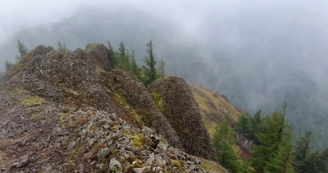
Before the first steep ascent, there was a long rock ridge, fairly narrow, and crowded with people. Crampons are not good on rocks, and I don't like the narrow space, so opted to go left (west) over a snow slope. I informed the 2 hikers close to me. Our hike leader James is not happy that I took off. Called me twice. I was well within eyesights. I told him that I'd join them above the rocks. We regrouped by a large cross with solar panel, as many others did. It's rather flat here. Clouds started to form.
As we moved up to the 2nd steep ascent, wind started. Not bad, but chilly enough that I put my fleece and gloves back on. At the next break, I told James that I would like to move up, since I was among the slower ones today. He okayed it. A couple of us trudged ahead. Shortly after, Patricia, who was ahead of me fell. She had yak-trax on. Bad on slopes. She slid ~100m down without hitting anything and stopped at the base of the slope, unhurt. I saw her hiking back up. So, all of us waited. Soon, I got cold, and decided to continue walking. The driver of our car is ahead of me, so I'm safe, logistically. However, soon after, I heard another scream, a skier lost control, fell, and lost one ski. She also stopped around the same place where Patricia stopped, and signaled her friends that she was fine. But she flew through my group. I waited and didn't see any movement, so continued up, completely unaware that her ski went over Tracy's foot, and knocked her off her balance, and she fell too. She scratched her hands badly on the ice to stop her fall. Luckily, she stopped without any injury other than some bloody skin on her hands. She wore micro-spikes. Having witness these two accidents one after another, the rest of the group (half of them on spikes) decided to hike out. I later heard another skier fell and hit some rocks. I didn't see that at all.
Lesson 1: crampons on slope, not micro-spikes.
Lesson 2: pay attention to your surroundings. Don't talk too much.
Lesson 3: don't stay too close to each other (especially behind someone), so you'll have space to dodge anything falling.
Lesson 4: do not put on crampons/snowshoes unless necessary. Too much weight add strain to the calf.

At the last ascent, I saw Brooke and Jack (her dog) hiking down. Met her earlier in the parking lot. Ice was hard here. I got to the rim at 1pm. The rim was lined with people taking photos. But Adams was obscured. Still, what a view. You can see the steam of the buldge inside the crater. Spirit Lake blue with reflection of neighboring hills. Mt Rainier looming ahead. Hood and Jefferson behind you. No wind!

I continued west for the summit. You can see the little dots of people at to right edge of my photo taken half way. The summit isn't much higher, but does push the horizon below the rim. Rainier and Adams are better placed.

Back to the rim where the trail ends. Surprised to see Linda, who was supposed to be heading to Mt McLoughlin. I told her that my group was behind due to the 2 accidents. A girl sitting next to her heard our conversation, and told me that she saw them moving downhill. Oops. I found Dan, my driver, and urged him to head down. He didn't even see the 2nd accident.
Because of the hard surface, glissade was unsafe. The skiers and snowboarders were also carrying their gear and walking down. I put on my rain pants hoping to glissade at some point. As I was putting back on the crampons, I felt cramps in my thigh. I guess I sweated more than I drank. I did manage a couple of short slides a bit lower where it was not too icy. I used one hiking pole to break, got it bended quite bad. Further down, it was slushy under the afternoon sun. My water bottle fell out twice. Skiers made worrisome scraping sounds. Dan, having bigger spikes, was going down fairly slowly. I had to wait for him. So I was able to eat my lunch, without delay our return. Dan was also having some muscle cramps, and I gave him a tube of hydration powder.
Lesson 5: drink even if you are not thirsty.
Lesson 6: bring ice ax if you want to glissade.
Back to the car around 3:30pm. James was waiting for us, quite upset. Oh, well. Back in Portland in 2 hours. I went back to the office to pick up my camping gear, and had some beer.
For more details about the trail, see
WTA.

 Ridgefield National Wildlife Refuge is not far north from Portland. We drove the 4 mile auto tour. There's a fee box where you deposit the $3 entrance fee. I asked the lady at the kiosk if she has any change. Answer is no, even though she was really nice. So, put $5 in the envelope. The auto tour was nice. Not as many birds as I hoped (probably should come back in 2 months). Apart from various ducks, we saw some swans and deers, about 4 herons, about 4 Nutria.
 The entrance near the NWR headquarter leads to Cathlapotle Plankhouse. Not open in winter. The big house looks nice under snow. The bridge over the rail track also looks nice.
 Drove to Catherine Creek to see Grass Widow. Too early. There were a few small ones blooming already. It was pouring around Hood River, just a few miles west. The Hood River bridge has increased toll 100% too to $2.