

 2015/8/13-16, the classic Wallowa River loop, in the Eagle Cap Wilderness, south of the small town of Joseph in eastern Oregon, ~5 hours drive from Portland. Hike #21 in Douglas Lorain's book "Backpacking Oregon", clockwise. Total 6 people, ~36 miles and ~7000' elevation gain. I did a bit more (orange line on the map) than the other 5. The entire loop is of gentle trail, mostly dusty/sandy, occasionally rocks. Nowhere steep. Countless lakes, autumn colors. Will come back when there's more snow on the mountains and more flowers on the meadows.
Thursday. Drive to South Wallowa Lake St Park (TH @4400') and hike to Aneroid Lake (7500'). 6.3 miles, 3200' elevation gain.
 Betty picked me up at 6:15am at Gateway TC. 3 women + 1 dog. Slow going. Breakfast, multiple bio breaks, even stopped at 1 gas station + 2 stores. Reached Joseph at 12:30. Meet the other car (2 guys 1 lady 1 dog) at the trailhead. Lots of parking west (right) as you go in, the other side is for trailers. More break and chitchat (typical downside with a friendly group). Bathroom with running water, big trees, green grass with shade, picnic tables. Didn't start hiking until 1:30pm. ~90°F.
 View of Wallowa Lake can be had 15-20 minutes into the trail. Soon, you left it behind. First long stop is 1 hour into trail, at a pond with some locked cabin. Along the way, my left arm was mostly in shade. Forest with some openings. Occasional views of the east fork Wallowa River. Encountered plenty people for a weekday, both on foot and on horses kicking off dust. 2nd long break 1 more hour later, no water here. I was getting slower, aftermath of a 2 hour sleep last night.
 There's a short diversion, one trail for inbound, one for outbound. Soon after the reconnection is a lovely meadow, with a creek running through. I would camp here, if tomorrow's mileage weren't long. Continued further to another meadow. At about 5:30pm, we reached the bigger Aneroid Lake.
  At 6pm, sun was already setting behind the mountains. Hazy. The sun was a pink ball. Our camp site is high on a rock. Fetching water is a chore. Everyone crawled into tent around 8:30pm.
Warm night. Woke up at midnight to release my bladder. Stars were not very bright. Clouds at low horizon. Strong smoke smell. Saw maybe 5 shooting stars, more flash light on the horizon behind trees without any obvious tails.
Friday: Hike to Frazier Lake (7120'), over Polaris Pass (8850'). 11.8 miles, 2200' elevation gain.
Alarm set at 5:10am. Didn't need to be so early. I walked to the southern end marshy area. Before the marsh, better camp sites, closer to water, 2 running creeks, some flowers. The cabin (Camp Halton) owner laid some boards over more muddy stretches. At ~5:45 clouds started to change color. The mountain top wasn't lit till 6. The rest of my group started getting up by 6:30. However we only headed out at 8am. Twice of 10 minutes drizzle before we even left.
 Gentle zigzag to a meadow, where a junction to Bonny Lake. Pick the right fork, going through the meadow, now brown with some aster and yellow daisy like flowers. 2 creeks now dry. Up more gentle slope to a lovely pass (~45.1893N, 117.2052W) east of Peters Point, 360° expansive views. A few minutes of drizzle, then it cleared out (albeit of the smoke which blows in every afternoon) the rest of the weekend.

 At ~10:50, I reached Polaris Pass. Grand views, windy, very smoky this weekend, so all distant mountains were barely visible. What a pity! Lunch and rest for an hour.
 Down Polaris Pass is endless zigzag, long and flat. If you cut short a couple of turns, you wouldn't know which way is up or down. At ~3:30pm, we reached Frazier Lake. Very smokey. I found a nice tent site more south than the rest of the group, who camped on grass at the lake outlet. Lake is shallow and muddy. After setting up the tent, I scrambled a bit up the hill to the SW. Didn't go far: too hazy for a better view. Later, I found an incoming creek south of the trail junction towards Hawkins Pass for a good wash. Water is better here.
Saturday: Hike to Horseshoe Lake (~7130'), over Glacier Pass (8500'). 8.5 miles, 1500' elevation gain. My favorite day.
 Alarm set at 5:30am. Clear blue sky. I scrambled up the same hill again, this time almost to the top. View of Little Frazier Lake, as the sun rose.

 Back to my camp, cooked breakfast, packed, and waited at the trail junction. At 8:35, I decided to go ahead alone. After getting out of the lake basin (some elevation gain), it's simply fabulous: along a beautiful jagged river valley, gentle grade, autumn colors are starting on the slope, very meadowy and green at creek's side. Then, above a short waterfall full of yellow monkey flowers, is gorgeously Glacier Lake (8166'). ~10am. A few little islands in the blue lake at the foot of steep granite cliffs. I dumped my pack at the junction (full of yellow monkey flowers) and headed east (left) along the lake shore. Lots of gentians. My group arrived shortly, and we had a long break. Betty informed me that camping here is not allowed. No wonder the lake is so pristine. However, I did see a couple of campsites (fabulous view).

 From here, it is steady up, but fairly short. 0.5 mile? Reached Glacier Pass at ~11:50. Brushy. Can only see one side. Glacier Lake is clear in view, but sadly the west side is again smokey. Didn't linger here. Zigzag down, some small creeks and meadows. An hour later, we reached Moccasin Lake (~7470'). Long lunch break. Smokey.
 I suggested visiting Mirror Lake (~7600'), but no one was interested, nor mind if I went alone. So I did. As I hiked up to Mirror Lake, the view of Moccasin Lake got much better. It's much larger than we thought. Mirror Lake is prettier: closer to granite. Also quite big. I found Lisa's group there, in the process of packing out. Very happy to chat with them. They came in from Lostine Meadow (Two Pan TH).
The Lake Basin loop trail from Mirror Lake to Douglas Lake isn't very interesting. The tiny Sunshine Lake provides an alternative camping option for those in Mirror Lake area (option to hike up Eagle Cap). I met John from Eugene and his college roommate from Colorado at Crescent Lake. John was wearing a Rim2Rim T-shirt. As I did that hike last year, we chatted a bit, and heard some stories of Grand Canyon, including a guy who did Rim2Rim over 100 times in a year. Soon after Crescent Lake is Douglas Lake. Both quite pretty. Douglas Lake is rather big. At the junction here, turn north (left), signed for Wallowa River TH. (otherwise, back to Moccasin Lake). At the next unnamed junction, I took right to visit Lee Lake (just a forest lake, no view of mountains), and then continued to Horseshoe Lake.  I found a very nice and big camping area when first encountered Horseshoe Lake (before a board crossing a muddy lily pond outlet) - see the view from the rock I camped on. Dropped my bag, and walked along the lake in search of my group. 10 minutes later, found them camping right next to the trail. It was already 5pm, and they were ready for dinner. I went back to my camp. Visited the lily pond next to the trail at sunset. It's rather swampy: not easy to find good footing. Swam a bit, washed, fought with 2 chipmunks for my dinner (they disappeared at ~7:30pm, and returned ~7am the next day).
Sunday: Hike out to trailhead, 9.4 miles, loss of elevation.
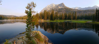 Woke up just before 6:00. Walked to a little island just west of my camp. Mist float above water. Very pretty and calm.
  Went to the lily pond for more photos, before breakfast and packing.
 I joined the rest of the group shortly before 8am - our set departure time. However, we didn't leave until 8:10. It's all the way down. Dusty and easy. Immediately after 2 creek crossings one right after the other, we reached 6-Mile Meadow at 9:20. A very nice area for camping. Flat valley bottom, tall mountains on both sides. From here on, it's flat, a bit rocky and muddy.
  Reached the junction to Ice Lake in an hour. A long break. Saw a few day hikers here. Lots of thimbleberry and raspberry, slowing me down from the first of the group to the last. As we approach to the TH, multiple trails split. I took the left (W) one to hike along the west fork Wallowa River. The river bank got steeper and more scenic towards the end. Arrived at the car shortly after noon.
Lunch at Terminal Gravity Brewery in the town of Enterprise. I had a buffalo burger and an Eagle Cap IPA. Both were ok. Outdoor seating is quite nice. Dog friendly.
Direction (~330 miles to downtown Portland):
* I-84 east to exit 261 in La Grand
* OR-82 east to Joseph
* OR-351 to the trailhead
 2015/8/30, Sunday. Rain. About a dozen amateur photographers and fake like me hiked along Siouxon Creek. Lots of camp sites along the creek. Water is low, so waterfalls are small. Siouxon Falls is about 2 miles in. Quite nice.
 There an over-kill bridge at Horseshoe Falls. A bit disappointing compared to when I saw it last year. We encountered a group of kids at the bridge, one of them is carrying 4 1-gallon water jars. There's a short trail to the left further along the trail to go down to the bottom of the falls for a better look. There, a nice camp site facing the lower half of the falls.
  Continue for another mile or so, without crossing another over-kill bridge, is the 14 Mile Falls. It's pretty low. The bridge itself straddles a small gorge, a good point where all my fellow hikers turned around (if not earlier).
 Cross the bridge, passing the little island full of camping remnants, 0.25 miles further is Chinook Falls. To get a better view of the falls or get closer, you have to wade water in a normal year. This year, I was able to get pretty close without taking off my shoes.


 .
.


