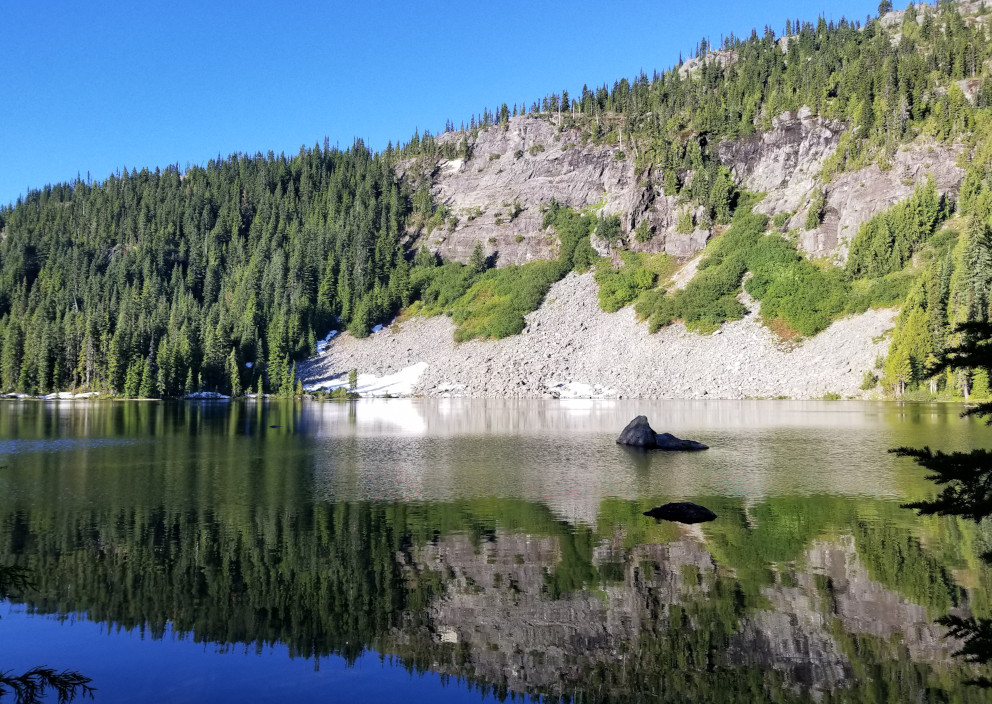
 We started hiking at 6:30pm, after I quickly swallowed my packed dinner. The trail is straightforward, zigzag in the trees to Squaw Lake, 7:40pm. This photo was taken on the way out with better daylight. Quite some mosquitoes. We were overtaken by 4 skiers here at the lake's outlet.
 A few more zigzags, the trail eases into Cathedral Pass, passing a few half-thawed mosquito ponds.
  Starting from here, snow, water or mud on trail at places, I regreted not putting gaiters on.
 At the junction of PCT (clearly marked), take the south bound west for ~1/3 mile, and bend around Cathedral Rock. Take Peggy's Pond trail, also marked. Narrow, on rocky slope. Be careful. Good view of Deep Lake below. View across the valley is quite nice.
  Just before Peggy's Pond, at least 2 pathes going up, minor confusion. We looked for clear ground for tent site. Saw only 1 small tent. It was already getting dark. Didn't hunt too much, camped near the pond's outlet, with an easy access to water. Ate some snack and went to bed. It was a bit cold in my 45°F sleeping bag.
7/3, Saturday. Didn't need to rise too early, since we had a whole day. Started hiking at 7:30am. A little confusing getting out of the basin, random trails to potential summer tent sites.
 Once reached the ridge, it was straightforward. Clear boot path. Heathers, penstemon, Jacob's Ladder and phlox dotted the rocky ridge.
  We took the ridge all the way to East Peak. Rarely had to skirt around. (On the way back, I took the snow route, marked on this photo.) The view is splendid on both sides along the ridge.
Some rock scrambling required. See this photo getting down to the col before East Peak.
 We went up East Peak first, thought it was Mount Daniel (wrongly marked on Gaia Map). Surprised to see others didn't bother to summit this one.
  Here's the marker on the summit.
  The view is splendid all around. Took a long break so I could take off my boots, and dry my socks. Ate a sandwich, enjoy the solitude. We had the summit to ourselves, except briefly for one trail runner and his dog. A few skiers gathered below the true summit.
 Now headed to the real summit (marked on Gaia as West Peak). I retraced my step back to the col and followed the trail on my map. The begining of the traverse below East Peak is extremely narrow on steep slope. Tread carefully. Then a short snow slope. S scrambled down the steep rock slope to the south, and rejoined the trail after the snow.
 After regain the ridge, stay on top. We took the right slope at the next bump, loose rocks, not good. On the way back, went over the top of the bump, and that was easier.
  Passed 2 hikers from the summit. We didn't bother with Middle Peak. Head straight to the true summit. Here is S on top of the summit rocks. Steep drops.
  The view is even better. Hinman's snowy expanse to the west. Peasoup Lake below. Took another long break, and took off my boots. S signed the summit registery. Had the summit to ourselves for over an hour.
 We headed down. Saw a few tents popping up on the meadowy and wet slope above Peggy's Pond. With plenty time left for the day, we headed to Circle Lake. Yes, you can see Venus Lake and Circle Lake along the ridge. But this provides a different angle. No one bothered to come this way. No footprints at all. We stopped at the plateau above the lake. I ate another sandwich hiding in the shade with the lake in front of me, and rest my feet. Plenty tenting sites here without neighbors.
Back at the camp, dumped the unused crampons. I went to investigate the camping area marked on the map and the creek, west of Peggy's Pond. Saw 2 other tents on the way, and one more by the creek. Busier than yesterday. Took a sunset photo. Returned to camp, refilled water. Heard another party moved in close by, but out of sight. Tried to read hiding in the tent from the mosquitoes, but soon dozing off. Went to sleep early. Stars were brilliant at night.
7/4, Sunday. Up before 5pm, and headed out at 6am. We reached TH at 8:30. Filled gas and checked SeaTac flight arrival info. Dropped off S ~11:30am, then my pack at home. S forgot his phone in the car, so I had to swing by his building again, before driving to the airport to return the car.
This is a keeper. I'll definitely come back. Maybe a week earlier (before mosquitoes), or in fall (after mosquitoes). This schedule is perfect: 2 nights with a full day for the climb.