 2015/9/19, Saturday. Meet at 7:30am, but the last person (Jeff) showed up 15 minutes late and then he wanted to buy a coffee and use the restroom in Fred Mayer. Just 20 minutes into the driving, our hike leader didn't turn off highway. We had to call her to get her turn around: more waste of time trying to meet up. Once we got onto the gravel road, her passengers wanted to pee on road. Guess whom I won't go backpacking with next time. After 4 hours, we finally made to the trailhead (Google suggested 2:20 for 86 miles. Yes, very rocky forest road). It took another 15 minutes to get all on trail. The only persons who did homework is me and my driver. Our hike leader didn't even know that this is a designated camping area. Dilly dally, we were slow going too. Yes, all legal campsites were taken. I found a site for our car of 3 at Russell Lake, and another site for the other car of 4 at Scott Lake, who will return Monday. Not legal, but on proper tenting sites, not on trail, like some of other campers did. It's very crowded. Barring these downsides, the scenery is great. Huckleberry leaves are shining red, grass are golden under sun. Very pretty time.
 There are 3 ways to get into Jefferson Park. Last august, I hiked in via Whitewater trail, which is the easiest to get to. Another option is via South Breitenbush trail. Today, we followed PCT via Park Ridge. As you drive in the bad road, you can see the Pyramid Butte. A loop parking lot next to the Breitenbush Campground, but you don't see the big lake at all.
  The trail starts in evergreen forest with some rhododendron trees and carpet of red huckleberry bushes. Soon, it goes through a short burnt area. Then back in forest, then meadow, and then rocks galore. A couple of small ponds amidst the rock piles still have water.
  View of Hood to the south, and sometimes Jefferson to the north. As you crest Park Ridge, Jefferson jumps on to you in grandeur. Lunch and regroup. A great place to stop and stare. I walked up along the ridge to the west end for better photos.
 The trail down to Jefferson Park goes along the ridge to the west for a bit, then slowly winding downwards, passing a plateau, then a drainage basin of Sprague Lake, now almost bone dry. Huckleberry bushes are a blazing red on the slope. In the park, not so much red, mostly yellow grass. The first lake you encounter coming down from Park Ridge is Russell Lake. All 3 camp sites were taken, when I went to check them out. I reported to our hike leader who just now arrived about the camping predicament. 2 of us decided to stay in a side campsite here, instead of moving 1 mile south to the main cluster of lakes.
 5 of us continued south to Rock Lake first, setup base camp in a large site, shared with another tent. Has view of mountain and lake. After checking out Rock Lake and Park Lake, I decided to go back and camp at Russell Lake - only 1 group of old ladies. Took my dinner, sat next to Russell and ate my dinner there. Then I walked to Rock Lake for sunset photos. By then, it was very crowded there, almost like a zoo, with dogs barking, tents on trail and in closed sections. I saw people wash and dump dirty water into the now shrunk lake. It was dark when I went back to my tent. My phone recorded ~30000 steps.
 9/20, Sunday, I set the alarm at 6:30. Got up and wait for sun to rise at the lake. Cooked my breakfast there. Then, I went east of the lake to check out the flat meadow. Encountered 0 person. More ponds. Took many photos of Jefferson reflected in water.
  . As I turned back towards PCT, I started to see hikers. Met the other 4 at Scott Lake again. One of them changed his mind and wanted to go back to town with our car today.
 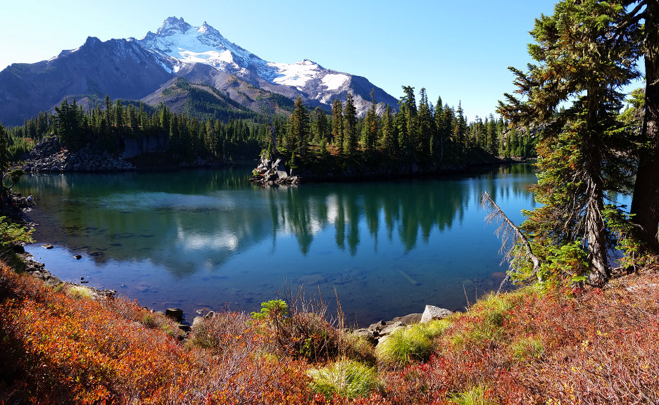 I visited Bayes Lake - very odd shaped. Headed back ~10:30am. At my tent site, our driver has already packed up, ready to leave. The other guy was gone. I headed out ~11:30. It's about an hour to reach Park Ridge, and another 2 hours to the car.
 Back to TH at 2:30pm. Our driver and I were the first ones arrived. I wanted to check out Breitenbush Lake. But we took the wrong trail, continued on PCT north ~3/4 mile to an unnamed lake. It gained quite a few hundred feet before flatten out to the lake basin.
  Almost all burnt trees along the trail. As the elevation gains, you can peek at Mt Jefferson, Breitenbush Lake and a large meadow with more more ponds and Lake Hilda SE of Campbell Butte, all through white tree trunks. The lake basin, however, is green, some huckleberry bushes too. Total today I walked ~35000 steps.
It took 3 hours driving back to downtown, where the other 2 were dropped off. I was dropped off ~15 minutes walk from my home. Thus ends a very colorful weekend. It didn't start smoothly, but finished nicely.