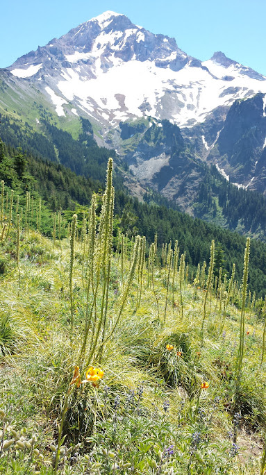
 From Top Spur trailhead, we took Timberline Trail south (at the 4 trail junction ~0.5 miles in, go straight - signed Timberline Trail) for a traverse around Bald Mountain where we see the Muddy Fork of the Sandy River rushing more than 2,000 feet below and first glance of Mt. Hood. Beargrass would be gracing this area just a month earlier. Then we climbed a ridge through a forest. Took an unmarked trail on the left that climbs a low saddle, and quickly cut over to the other fork of the Timberline Trail. (If you miss this informal route, you will reach a log stile after just a few feet.) Turn right, more noble fir forest, passing the McGee Creek Trail (no. 627) at mile 1.6 (4370') and another wilderness registration sign. At ~2.5 mile, reached the first of two steep meadows, with better views of the mountain to a stream crossing and colorful meadows. After the second steep meadow, a short side trail leads up to a high spot at 5133' elevation. This is a good spot for lunch or another possible camp spot. The main trail crosses more streams, before leveling off in more open country, with lush meadows and stands of ancient mountain hemlock. At mile 3.9 (5600') jnt Mazama Trail (no. 625, or Cathedral Ridge Trail) on the left. A short distance down this side trail is a pond and a campsite, and 3.1 miles down to the Mazama Trailhead. In about 0.1 miles the main trail reaches a seasonal stream coming down an alpine valley. Just before the stream is a side trail going up to a campsite. Continue another 0.2 miles to the new route to McNeil Point, which replaces this older route, marked with a sign "McNeil Point".
 Take the McNeil Point Trail. Soon, you'll be in the Eden. Loss Lake, Mount Saint Helens, Mount Rainier and Mount Adams, also far below, our route across Bald Mountain. Pink glory goes on for awhile. There's a historic stone shelter one-quarter mile from the crest. This is at mile 5 (5900'). Around the hut, lots of Anemones going to seeds. A family was playing frizbee in the snow (in T-shirts of course), when we walked by. Lofty and beautiful camping area.
On the way back, we encountered Rick Johnson's small afternoon group. They were going to McNeil point via a short cut. I'm curious what that is.
8 people. As with Mary Vogel's hike, I had a refresh course on flowers.