Monday, April 24, 2006
Thursday, April 20, 2006
2006.4.19. The last talk of Seattle Opera's "Opera's Dangerous Opposites" series. As always, Seattle Opera's education director Perry Lorenzo and novelist Rebecca Brown discuss (and sometimes argue over) the social background of the author and composer, themes in the work. This evening, they spent most of the time talking about Shakespeare, the era of James the 1st, and various adaptations of Macbeth. It has always been a fun. A pity that it is being discontinued after 5 seasons. Not enough money?
Sunday, April 09, 2006
2006.04.07. Preview of Double Take at EMP. A small gallery on the 2nd floor, houses about two dozen paintings and a couple of photographic prints (said to be Paul Allen's personal collection), exhibited by groups of two to four, with a verbose audio guide trying to make some connection (often contrived) in the pairing of each group. Interesting view point, however. The Renoir, a Turner, and three Monet's are definitely the highlights. Surprised to find a reception after we filed through the crowds in the exhibition room.
Thursday, April 06, 2006
2006.4.2. Arizona. Part 5 of 5.
2006.04.02 Northeast Arizona. Last Day:
 Oak Creek Canyon starts 14 miles south of Flagstaff on US 89A. Make sure to stop at the Oak Creek Canyon Vista at the the north tip of the canyon. The next 9 miles zigzag down to the bottom of the canyon. At the Call of Canyon ($7 parking), we hiked the West Fork Trail into a narrower canyon (6 mile/rt) along a brook. Steep, red walls, and maybe 10 creek crossings.
  Further down south (7 miles north of Sedona), Sliding Rock State Park ($8) is a fun place.
  Views spectacular, rocks redder, air drier, warmer, but the natural water slide cools you down. Tons of sun-bathers and kids splashing and running with bare foot.
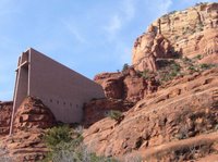 Sedona is a chic touristy town at the mouth of Oak Creek Canyon. Isolated rugged buttes rise from flattened land. They are said to invoke the power vortexes by the believers. As 89A approaches to town center, you feel the draw. Cars just pulled along the road, double parked. Everyone is in awe. The best place to be inspired is from the starkly beautiful Chapel of the Holy Cross, just south of town on US 179.
 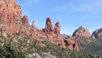 Designed by Marguerite Brunswig Staude, built in 1956. Breathtaking view all around. More of these, I may be converted! Another spot to feast on a 360o vista is on Airport Road (off 89A), where you can climb on the Airport Mesa in less than 5 minutes (and soak in a "masculine or electric energy").
 Arcosanti is an interesting utopia commune, aimed to create a modern eco-friendly urban living. It's in the middle of nowhere (exit 262 off I-17, ~1 hour north of Phoenix), 2 miles poor dirt road into the desert. We stayed in one of their spartan guest homes.
 Oak Creek Canyon starts 14 miles south of Flagstaff on US 89A. Make sure to stop at the Oak Creek Canyon Vista at the the north tip of the canyon. The next 9 miles zigzag down to the bottom of the canyon. At the Call of Canyon ($7 parking), we hiked the West Fork Trail into a narrower canyon (6 mile/rt) along a brook. Steep, red walls, and maybe 10 creek crossings.
  Further down south (7 miles north of Sedona), Sliding Rock State Park ($8) is a fun place.
  Views spectacular, rocks redder, air drier, warmer, but the natural water slide cools you down. Tons of sun-bathers and kids splashing and running with bare foot.
 Sedona is a chic touristy town at the mouth of Oak Creek Canyon. Isolated rugged buttes rise from flattened land. They are said to invoke the power vortexes by the believers. As 89A approaches to town center, you feel the draw. Cars just pulled along the road, double parked. Everyone is in awe. The best place to be inspired is from the starkly beautiful Chapel of the Holy Cross, just south of town on US 179.
  Designed by Marguerite Brunswig Staude, built in 1956. Breathtaking view all around. More of these, I may be converted! Another spot to feast on a 360o vista is on Airport Road (off 89A), where you can climb on the Airport Mesa in less than 5 minutes (and soak in a "masculine or electric energy").
 Arcosanti is an interesting utopia commune, aimed to create a modern eco-friendly urban living. It's in the middle of nowhere (exit 262 off I-17, ~1 hour north of Phoenix), 2 miles poor dirt road into the desert. We stayed in one of their spartan guest homes.
2006.4.1. Arizona. Part 4 of 5.
2006.04.01 Northeast Arizona. Day 4: 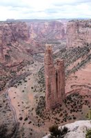
Canyon de Chelly National Monument (2hrs SE of Monument Valley) is a living monument, one of the longest continuously inhabited landscapes of North America. You can gaze down from the rim at 12th century Puebloan cliff dwellings and white sheeps grazing at the same time. The park consists of two major canyons - Canyon de Chelly (pronounced as duh shay) in the south and Canyon del Muerto in the north.
The South Rim Drive climbs slowly. It first stops at the Tunnel Overlook, where a short narrow canyon feeds into Chinle Wash. The 2nd stop overlooks the junction of Canyon del Muerto and Canyon de Chelly, as well as two small Pueblo ruins.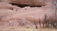 The 3rd is your only chance to descend to the canyon floor without a guide. White House Ruin trail (600 feet drop and 2.5 mile/rt) winds along the canyon cliffs, passes by some Navajo homes, acrosses Chinle Wash, and ends in front of the 80-room White House Ruins (1040 - 1275). Try to spot a couple of ancient drawings made with the desert varnish (formed by seeping water reacted with iron in the sandstone). The next stop overlooks the aptly named Sliding House ruin. The last, at mile 17, and the most impressive overlook is named after two freestanding 800 ft pinnacles called Spider Rock.
The North Rim drive is about 15 miles. Antelope House Overlook is named after the paintings of antelopes next to a cliff ruin, made by a Navajo around 1830. The last two stops are next to each other: Mummy Cave (two mummies were found in burial urns below the ruins) which was occupied from 300 to 1300, and Massacre Cave (Spanish military killed 115 Navajo here in 1805).
It took us close to 5 hours to go through all these sights.
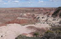 After a brief stop at Hubbell Trading Post (36 miles south on US 191), we drove another hour to the Petrified Forest National Park off I-40. The north part of the Park is an area of badlands called Painted Desert: expansive red barren hills. Dinosaurs fossils have been discovered in the vicinity.
 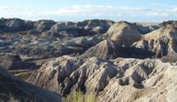 Driving along the park's 27 mile road across to the south of I-40, you came across blue and dark barren hills, a bit sinister. Aptly named The Teepees, and Blue Mesa. These are erosions colored by manganese, iron and other minerals.
 The park's largest archaeological site, Puerco Pueblo, contains the remains of homes (complete ruin) and lots of petroglyphs on the stones. Next to this stop is Newspaper Rock, a rock covered with ancient logs.
 At Agate Bridge stop, you'll see an unbroken petrified log laid across like a bridge. At Jasper Forest and Crystal Forest and further south, the land is littered with large crystallized tree trunks, remains of a lush Triassic period. Rainbow Forest Museum close to the south entrance of the park is also the start of several short trails dotted with petrified woods.
Two hours later, we managed to arrive at Josephine's at Flagstaff in time for a wonderful dinner in this cozy little house. A practical note on hotels: do NOT stay along the east route 66, as it's parallel to a train track. Very noisy.

Canyon de Chelly National Monument (2hrs SE of Monument Valley) is a living monument, one of the longest continuously inhabited landscapes of North America. You can gaze down from the rim at 12th century Puebloan cliff dwellings and white sheeps grazing at the same time. The park consists of two major canyons - Canyon de Chelly (pronounced as duh shay) in the south and Canyon del Muerto in the north.
The South Rim Drive climbs slowly. It first stops at the Tunnel Overlook, where a short narrow canyon feeds into Chinle Wash. The 2nd stop overlooks the junction of Canyon del Muerto and Canyon de Chelly, as well as two small Pueblo ruins.
 The 3rd is your only chance to descend to the canyon floor without a guide. White House Ruin trail (600 feet drop and 2.5 mile/rt) winds along the canyon cliffs, passes by some Navajo homes, acrosses Chinle Wash, and ends in front of the 80-room White House Ruins (1040 - 1275). Try to spot a couple of ancient drawings made with the desert varnish (formed by seeping water reacted with iron in the sandstone). The next stop overlooks the aptly named Sliding House ruin. The last, at mile 17, and the most impressive overlook is named after two freestanding 800 ft pinnacles called Spider Rock.
The North Rim drive is about 15 miles. Antelope House Overlook is named after the paintings of antelopes next to a cliff ruin, made by a Navajo around 1830. The last two stops are next to each other: Mummy Cave (two mummies were found in burial urns below the ruins) which was occupied from 300 to 1300, and Massacre Cave (Spanish military killed 115 Navajo here in 1805).
It took us close to 5 hours to go through all these sights.
 After a brief stop at Hubbell Trading Post (36 miles south on US 191), we drove another hour to the Petrified Forest National Park off I-40. The north part of the Park is an area of badlands called Painted Desert: expansive red barren hills. Dinosaurs fossils have been discovered in the vicinity.
  Driving along the park's 27 mile road across to the south of I-40, you came across blue and dark barren hills, a bit sinister. Aptly named The Teepees, and Blue Mesa. These are erosions colored by manganese, iron and other minerals.
 The park's largest archaeological site, Puerco Pueblo, contains the remains of homes (complete ruin) and lots of petroglyphs on the stones. Next to this stop is Newspaper Rock, a rock covered with ancient logs.
 At Agate Bridge stop, you'll see an unbroken petrified log laid across like a bridge. At Jasper Forest and Crystal Forest and further south, the land is littered with large crystallized tree trunks, remains of a lush Triassic period. Rainbow Forest Museum close to the south entrance of the park is also the start of several short trails dotted with petrified woods.
Two hours later, we managed to arrive at Josephine's at Flagstaff in time for a wonderful dinner in this cozy little house. A practical note on hotels: do NOT stay along the east route 66, as it's parallel to a train track. Very noisy.
2006.3.31 Arizona. Part 3 of 5.
2006.03.31 Northeast Arizona. Day 3:
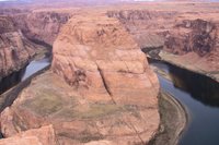 Early in the morning, we went for a 1.5 mile/rt hike to the Horseshoe Bend viewpoint on US 89 just south of milepost 545. From the edge of the cliff, you see the Colorado River making a huge bend hundreds of feet below. The sheer mass of the rocky walls are awe inspiring. The water is green and calm. It's fun to jump or crawl around the edges.
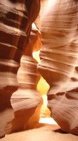
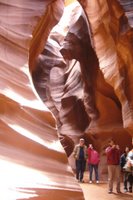 Antelope Canyon is located 3 miles east of Page on US 98 (at milepost 299). It can only be viewed with a Navajo guide. $20 + tax + $6 entry fee gets you an 1.5 hour tour from downtown Page (you can linger in the canyon for about 50 minutes). It's also possible to drive to the gate of the tribal park and hire a guide there (to save $5 and some time). This slot canyon is only 1/4 mile long, a couple of feet wide. Curved sandstones glow with light, even though it was overcast when we were there. (I've timed to come here around noon, but no one can plan the weather.) You'll encounter many would-be photographers with their fancy lenses and tripods.
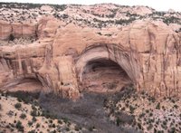 Navajo National Monument is about 1.5 hour east of Page, 9 miles on a side road of US 160. A short hike leads to an overlook of the 13th century Betatakin cliff ruin across from a valley. (I do not recommend this if you've seen or will go see a cliff dwelling closer, like what we would do the next day.)
 One hour later, we arrived at Monument Valley Tribal Park in Utah shortly before 5pm, and the gate was already closed. Unable to drive in, we walked to the viewing platform. What a sight!
  Although many of the towering monoliths can be viewed along the road, it's nothing like being closer. Too bad, no sunset.
 Early in the morning, we went for a 1.5 mile/rt hike to the Horseshoe Bend viewpoint on US 89 just south of milepost 545. From the edge of the cliff, you see the Colorado River making a huge bend hundreds of feet below. The sheer mass of the rocky walls are awe inspiring. The water is green and calm. It's fun to jump or crawl around the edges.
 Antelope Canyon is located 3 miles east of Page on US 98 (at milepost 299). It can only be viewed with a Navajo guide. $20 + tax + $6 entry fee gets you an 1.5 hour tour from downtown Page (you can linger in the canyon for about 50 minutes). It's also possible to drive to the gate of the tribal park and hire a guide there (to save $5 and some time). This slot canyon is only 1/4 mile long, a couple of feet wide. Curved sandstones glow with light, even though it was overcast when we were there. (I've timed to come here around noon, but no one can plan the weather.) You'll encounter many would-be photographers with their fancy lenses and tripods.
 Navajo National Monument is about 1.5 hour east of Page, 9 miles on a side road of US 160. A short hike leads to an overlook of the 13th century Betatakin cliff ruin across from a valley. (I do not recommend this if you've seen or will go see a cliff dwelling closer, like what we would do the next day.)
 One hour later, we arrived at Monument Valley Tribal Park in Utah shortly before 5pm, and the gate was already closed. Unable to drive in, we walked to the viewing platform. What a sight!
  Although many of the towering monoliths can be viewed along the road, it's nothing like being closer. Too bad, no sunset.
2006.3.30 Arizona. Part 2 of 5.
2006.03.30 Northeast Arizona. Day 2:
 A detour loop on US 89 leads to Wupatki National Monument, passing Sunset Crater Volcano National Monument (not interesting if you've already seen a volcanic landscape). Wupatki Ruin is much more interesting, as you can walk next to it or even sit in kiva. The largest of the few Sinagua ruins here from around 1100 AD till shortly after 1200 AD. Three story pueblo, close to 100 rooms, a natural blow hole of cool underground air.
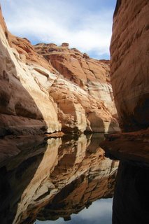 Lake Powell was formed after the construction of Glen Canyon Dam which started in 1956. It took 10 years to build and 17 years for Colorado River to fill the lake to its full capacity (almost 200m deep at the face of the dam). It's possible to visit the dam at the Carl Hayden Visitor Center just north of Page. We took a short boat cruise on Lake Powell towards Antelope Canyon. Impressive scenery. (The upper deck could be cold, as the boat can go fairly fast). The whitish coating on the red-rock cliff is the calcium carbonate deposit left over the past 7-8 years of drought.
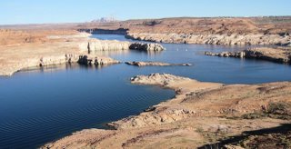 Dining at the Rainbow Room in the Lake Powell Resort and Marina is a must, not for the food, but for the sweeping view from the 180 degree circular window. The Resort is also where these boat tours leave.
 A detour loop on US 89 leads to Wupatki National Monument, passing Sunset Crater Volcano National Monument (not interesting if you've already seen a volcanic landscape). Wupatki Ruin is much more interesting, as you can walk next to it or even sit in kiva. The largest of the few Sinagua ruins here from around 1100 AD till shortly after 1200 AD. Three story pueblo, close to 100 rooms, a natural blow hole of cool underground air.
 Lake Powell was formed after the construction of Glen Canyon Dam which started in 1956. It took 10 years to build and 17 years for Colorado River to fill the lake to its full capacity (almost 200m deep at the face of the dam). It's possible to visit the dam at the Carl Hayden Visitor Center just north of Page. We took a short boat cruise on Lake Powell towards Antelope Canyon. Impressive scenery. (The upper deck could be cold, as the boat can go fairly fast). The whitish coating on the red-rock cliff is the calcium carbonate deposit left over the past 7-8 years of drought.
 Dining at the Rainbow Room in the Lake Powell Resort and Marina is a must, not for the food, but for the sweeping view from the 180 degree circular window. The Resort is also where these boat tours leave.
Tuesday, April 04, 2006
2006.3.29. Arizona. Part 1 of 5.
2006.03.29 Northeast Arizona. Day 1:
We arrived at Phoenix airport around noon. All car rental companies have their offices in a collective area west of the airport: add >15 minutes to your travel.
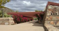 Taliesin has been a school set up by Frank Lloyd Wright more than 50 years ago. Built over the years by his apprentices. It still is a reputable architecture institution. It emphasizes the harmony between a building and its natural settings. There are many interesting details. Doors here are rather small and sometimes obscure, as they only serve the purpose of leading you in and out of a functional space.
 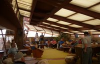 In this famous living room, the entry way is narrow and consists of two 90 degree turns, channeling the eyes to different part of the room. Ceilings are mostly made of canvas to diffuse light. Many rooms are not closed, oriented to the seasonal air flow. The concert hall has angled seats, so when you are seated with one leg over the lap of the other and one arm set on the back of the seat, your eyes are naturally pointed to the screen without needing to turn the neck!
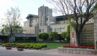 Arizona Biltmore is Wright's first project in Arizona, and lured him to the warm climate here. It has its own little moat and cute bridges, a bit medieval, yet pleasant.
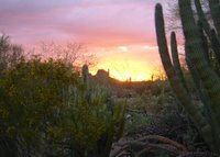 After stopping at Cosanti for 5 minutes, we headed to Desert Botanic Garden. A good place to learn the names of every cactus you can imagine and the way of life in the old days. Birds fly in and out of saguaru, chirping. The cutest here is Gambel's Quail.
Dinner at Roaring Fork in Scottsdale, where I had the most tender duck I've ever tasted. I also highly recommend fondue with baby lamb racks for starter. 2 hours later we arrived at Flagstaff in snow!
We arrived at Phoenix airport around noon. All car rental companies have their offices in a collective area west of the airport: add >15 minutes to your travel.
 Taliesin has been a school set up by Frank Lloyd Wright more than 50 years ago. Built over the years by his apprentices. It still is a reputable architecture institution. It emphasizes the harmony between a building and its natural settings. There are many interesting details. Doors here are rather small and sometimes obscure, as they only serve the purpose of leading you in and out of a functional space.
  In this famous living room, the entry way is narrow and consists of two 90 degree turns, channeling the eyes to different part of the room. Ceilings are mostly made of canvas to diffuse light. Many rooms are not closed, oriented to the seasonal air flow. The concert hall has angled seats, so when you are seated with one leg over the lap of the other and one arm set on the back of the seat, your eyes are naturally pointed to the screen without needing to turn the neck!
 Arizona Biltmore is Wright's first project in Arizona, and lured him to the warm climate here. It has its own little moat and cute bridges, a bit medieval, yet pleasant.
 After stopping at Cosanti for 5 minutes, we headed to Desert Botanic Garden. A good place to learn the names of every cactus you can imagine and the way of life in the old days. Birds fly in and out of saguaru, chirping. The cutest here is Gambel's Quail.
Dinner at Roaring Fork in Scottsdale, where I had the most tender duck I've ever tasted. I also highly recommend fondue with baby lamb racks for starter. 2 hours later we arrived at Flagstaff in snow!
Subscribe to:
Comments (Atom)