Thursday, August 24, 2023

2023.8.24. Sunset at McClellan Butte

8/24. Thursday. 4 of us decided to watch sunset at McClellan Butte. I hitched a ride with AB from Amazon's Mayday at 4:30, right next to I-5. The TH is well signed, off I-90 exit 42, a very short gravel road. A large parking lot, an outhouse (I was told it was clean), and a heap of trash (dorm-size fridge, tire, lawn mower...).

We started hiking around 5:30pm. Sunset is at ~8pm, and the elevation gain is about 3800'. The first 2 miles is easy, crossing some road twice. There is a different parking spot near the 2nd road crossing, which can save 650' and 1.8 mile.

I was going at the top of my speed, for fear of not catching the sunset. But soon after the zigzag starts, I was lagging behind. 2500' in 2.5 miles. There are a couple of "creek crossing"s, which were bone dry. The air was hazy, but didn't smell like smoke.

The trail turns 90° skirting the boundary of the watershed. Many no-tresspassing signs. Soon another 90° turn, now more or less on a ridge, even going downhill. Finally the butte came in view, shining in the setting sun.

When I reached the bottom of the scramble, the others were taking a snack break. Oddly, I was the first to reach the summit. 7:45. The short scramble is fun. Solid rocks with good foot/hand holds. But, yes, exposure, and steep. So caution is needed, especially coming down. Here's VJ and AB coming down slowly.

The summit has fairly good view, even on a hazy day like today. Has a broad area just below the top rocks, where we ate our late dinner and waiting for the sun to set. MY went down and ate his dinner there. We saw Rainier, the moon, the peaks in the Alpine Lakes aera. The sun set at 8:01 for us. We started down 5 minutes later. Now it looked very steep!

All was smooth on the way out. I-90 closed I-5 exits. AB drove into the tunnel, my first time in this new tunnel. It has a toll. I got home shortly after 11:30pm.

Wednesday, August 23, 2023

2023.8.25. Plant Camp

This is the 5th or 6th Plant Camp at Amazon's Day 1 field. I finally got to try it. Got a mini succulant plant. I moved it to a larger pot. Will see how long it survives.

Saturday, August 19, 2023

2023.8.19. Mount Skokomish via Lake of the Angels

2023.8.19. Saturday. Went to Olympics to escape the smoke. D.R. planned to scramble Skokomish and Stone, no one else signed up. I got picked up at 6:05am by the library. Probably should have started earlier if I were to climb both peaks, because for my speed, over 7300' gain would need more time. Arrived at Putvin TH towards Lake of the Angels shortly after 8 (D.R. drives fast). Chilly (~52°F). About a dozen cars parked here. There's an out-house, but I prefer trees. Ate a banana, started hiking at 8:20am.

The first 1.2 miles to a decommissioned road is normal. It gains ~830'. I could barely keep up with D.R. here. We didn't visit the grave marker of Carl Putvin, a trapper. Turn left for a very short walk to another trail sign: 2 miles to the lake, 1 mile to the park boundary. Soon after crossing the road, the steepness increases. I was lagging behind more and more, short breath and pounding heart, and sweat poured out. Had to stop multiple times and drink. Eating trail mix wasn't helping. Ate an energy bar to pump up my blood sugar (probably should have eaten a larger breakfast). D.R. had to wait for me again and again. Once the trail becomes scrambly, our ascent slowed, and I was able to continue without stopping.

Reached a small pond shortly after 10am, about 1.5 miles from the road, 2200'. 7 minutes later, it's the national park boundary. A bit swampy here. Some short wooden wooden board, muddy at times. No mosquito problem, probably due to the dry summer. The map shows the pond inside the park, which is in conflict with the sign.

After this meadowy area (not many flowers), a reprise from the steep ascent, the trail gets steep again before easing into the basin where Lake of the Angels is. Saw a young black bare before the lake. This photo is from D.R.

The lake is quite pretty. Saw a guy fishing (not catching). There are tiny fish in the shallow lake. Water is very clear. The outlet of the lake has lupine and monkey flowers, very small flow. Had a 20 min break, and refilled water.

Walked the south shore of the lake. At its western end, saw two small tents next to each other. Didn't see any other tents or people. Not sure where were the people who came from all those vehicles at the TH. Now easy scramble over the boulders towards the head of the North Fork Skokomish River. No water though. There are tracks here and there, but doesn't seem to matter which way to take. At a saddle where the park boundary is (no sign), dropping down, and began a long traverse on a steep-ish scree slope. Below the saddle (outside of the park), there's a small lake, and 2 patches of snow.

We stayed high on the way in, got down to the snow on the way out. Both are equaly unpleasant, but not too bad. The scree isn't too soft to sink my feet in, so, a bit slow going. The best flower is the slope after this bare section. Equally steep. Traversing all that. Took ~1 hour.

Then, started scrambling up. Some soft scree here, before the rocky section. Too many peaks to know which one to go for. Had to check my GPS location all the time. The last 10 minutes is fun scramble. Slate like rock. Not too cramply. Saw Olympic Bluebell on the rocks here, that made my day! Cross over a ridge, got down a notch and narrow ridge scramble. The sharp top is full of wasps and flies. I walked NW a bit for a better view below and to the north. Sat under a big rock for my well-deserved lunch. ~2 miles, 2000' from the lake.

Headed down at 1:05. Back at the lake at 2:30pm. On the scree slope, we tried going lower, but similar. I was able to fill my water bottle with snow on the way back. Started to smell smoke from time to time. I managed to fall on a rock near the bottom, strained my back muscle. No problem walking, but having pain at some positions. I decided to quit for good, to relax at the lake, so D.R. can pick up his normal speed for Stone. That's another 1 mile ~1700'! Refilled water, ate more snack. He left for Stone at 3pm. I washed my feet in the lake, found a big log in the shade to sit on, and read a few pages of my book.

I headed out a little before 4pm, and reached the car in 2 hours: not much faster than going up, but I wasn't in a hurry. The air was getting visibly worse. Saw a grouse. Multiple water sources along the way. Encountered quite a few backpackers coming up. Passed one couple, the husband was moving very slowly. Later, saw 2 guys carrying a pair of cruches. They told me that the husband I saw earlier tore his ACL. Passed another young couple. Below the road, saw 3 rescue members, two of them pushing a stretcher on single fat wheel.

Back in the car, changed clothing, took a nap. D.R. returned at 7pm. So fast. He complained about the air. I'm not surprised. It's much worse than earlier. He said that Stone had almost a trail the entire way. The scree to the saddle isn't bad. It took him only one hour to get to the summit.

Accident on I-5 causing delay. Hazy all around. I was dropped off ~9:15. Total for me is about 5500' gain 11 miles.

Sunday, August 13, 2023

2023.8.11-13. Perseids at High Divide

8/11 Friday. I wanted to camp away from city light this weekend for the meteor shower. My hiking buddy was needed in office on Sunday, so we settled on Excelsior Pass via Damfino Lake, a short hike to get back out fast Sunday morning.

Headed out at 3:20pm to catch the lightrail. Got picked up at 4pm. No traffic in Seattle, but congestion around Lynnwood and Marysville on I-5. Not sure what's the cause. Wasted an hour on the road, despite of following Google's alternative suggestions: the alternatives were also choked.
Once turned off Hwy-520, I was pleasantly surprised (even though I half-expected it because of some trip report) that Canyon Creek Road (NF31) has greatly improved since my last visit eons ago. The 15 miles (half paved) forest road still has bumps and holes, but now passable by a regular sedan. 3 other cars at the TH, one of thich is low clearance.

We started hiking shortly before 8pm. On the way saw a band of orange under dark grey sky. Damfino Lake area has 3 ponds. The middle one may be all year round. All look mosquito-y. Boardwalk over potentially muddy ground.

We reached the pond at the Excelsoir Pass ~9pm. It's too shallow and small to my liking. We continued towards to the ridge. A tent and 2 chairs took the center stage. Continued over Excelsoir Peak and down to another saddle. Pitched the tent in the ever dimming light. Settled down to watch the sky. I passed out after seeing only one meteor - a shining one.

Total today, maybe 3 miles, 1400'.

8/13, Saturday. Cloudy. One recent trip report on WTA mentioned running water on the south side of Excelsoir. FIrst, I walked south to hunt for water. Didn't find any, but saw 2 nice camp sites (unoccupied). Back to camp, picked up empty water bottles and pouches, and walked back down to the creek we walked by yesterday. I took a shortcut, was cliffed out at one point, but managed to get to the creek much higher than where the trail crosses it.
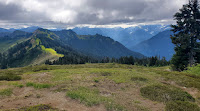
High Divide is a ridge walk, no tree cover. Thick clouds today provided nice shade and cool temperature for walking. The initial walk is not truly on the ridge, rather on the south side, where the better view is. It's ~4.2 miles from camp to Welcome Pass (drop ~1150' gain ~700'). Passing this brown pond with bear paw prints on the edge. There's a steep trail going down to Hwy-520 from Welcome Pass, if you want a work-out.

Continued on High Divide, soon on a proper ridge, now going north. Only one snow patch left, large enough to last awhile. Refilled my water bottle here. You can see Chilliwack on the Canadia side. No wonder, last night, the sky wasn't very dark.
Took a long lunch break at Keep Kool Butte, our turn-around point, waiting for the sun to shining on the many ponds below Yellow Aster Butte. A few flies. ~1.5 miles, 1000' from Welcome Pass. All morning, we didn't see another human.

On our way back, we met maybe 6 people total. One ask us where is the next water. Saw this cool cave. Didn't peek inside to look for its host. The clouds were burning off, and the sun was shining on the huckleberry leaves. Not many berries or no berry at all. Fireweeds were blooming happily. Other flowers were not doing well here.

Back at camp, we picked up towels and water bottles to go down to the creek. We could see quite a few people on top of Excelsoir. It's good that we camped on this side, so avoided all the day hikers. Checked out the pond first, it still doesn't look nice in the day light. A group was camping south of it in the trees. The creek had a lot of monkey flowers blooming, and valarians. Washed and filled water.

Back at the camp with 4 litres of water. Rest, read my book, hiding in the shade. Cooked dinner (Mexican refried beans and mashed potatos). After 8pm, I headed up to Excelsoir Peak to wait for the sunset. Saw 1 more tent at the pass to the north, and one more with a dog to the south. The setting sun casted a beautiful hue on the landscape.

Clearer sky today. Waiting for the meteors. I fell asleep, but set alarm for midnight. Counted 14 big meteors. Waiting too long for my 15th, fell asleep. My partner said at 2am, the meteors were going every minute, some times more than one on the sky.

Total today ~13 miles, ~3000'.

8/13, Sunday. Sunny. Packed up and hiked down. Started to seeing people coming in. We got back to the car shortly after 9am. Made one gas stop. Smooth sailing. No traffic. Got dropped off shortly after noon.

Took the lightrail, but we were all chased off the train at Capitol Hill Station. Had to take a shuttle bus to downtown. Very crowded. It was getting quite hot. I'm glad to be back before it got hot. I spent the afternoon reading a book. After finishing the laundry, I turned off my water heater. The next week, it was going to the 90°Fs.

Saturday, August 05, 2023

2023.8.5. Twin Falls + Mt. Washington

8/5, Saturday. 7:30 start from Seattle. Weather forecast is thunderstore on both afternoons. Abandonned my backpacking plan, headed for a short hike in Snoqualmie Pass. As we drove east on I-90, it started to rain, not just drizzle. Took the next exist out for Twin Falls. A real "last-minute" change.

I haven't been to Twin Falls for ages. It's a nice family hike close to the city. I used my umbrella. A very nice water seep and dripped over the rocks. Nearby, we scrambled down to the 2nd pool on this photo, which was taken from a foot bridge. It would be a good swimming pool on a hot day. Today it was muggy. The rain did stop by the time we arrived at the pool. Need to be careful on the now-wet rocks.

Continued on the trail, connecting to Palouse to Cascades trail. Shortly after, we took the right hill to Mount Washington. On the way, saw this rock with many climbing hooks. Plenty fireweeds blooming near the summit. Very few lupines. View of the Cedar River watershed. Took a long break at the rocks here, about 40 minutes. Before hiking down, we walked up to the true summit in the trees, peeking towards I-90. It started to rain again.

When we returned to the parking lot, it was very busy. The rain had stopped. One way 5.7 miles, 4100' gain, 400' loss. A nice outing on a wet day, and a good workout.

On the drive home, traffic on I-90 over Lake Washington. A lot of people. Blue Angles were flying.

Friday, August 04, 2023

2023.8.4-6. Blue Angels

Blue Angles flew for SeaFair this weekend over Lake Washington in the afternoons. They are very loud. Always good to see. However, by the time I heard the boom, the planes were gone. Only managed to catch the planes on one photo. I tried many on Friday. Was on the 10th floor of the library with glass walls, but only heard them, didn't see them at all.

Thursday, August 03, 2023

2023.8.3. First Thursday at Seattle Art Museum

8/3 Thursday. I visit SAM frequenly on First Thursday. Usually only the temperoary exhibits, because it's a work day, and I don't have much time to spare.

Today, I'm very impressed with this solo exhibition by the Ghanian painter Amoako Boafo. I'm especially like his strokes (finger) for the skin, and his "no paint" scheme of using the background, like the white shirt of this man in the portrait.

Tuesday, August 01, 2023

2023.8.1. Summer at South Lake Union

8/1. Tuesday. Summer in SLU was in full swing when I walked by. Photo booth for an instant photo. You can write a post card and they'll mail for you. An ice cream cart giving away 6 flavors of sweet treat. Very busy.

I also noticed the newly painted stairs.

The very same evening, Amazon Symphony Orchestra performed their summer concert "New Beginning". Very fitting for today. A better turn-out than the last concert. Same quality. More familiar tunes.