Labor Day long weekend. My hiking friend O came again from Portland on Friday. She signed up a Facebook hiking event at Jade Lake, and needed to be there on Saturday. Even though the Deception Creek TH from Hwy-2 is shorter to drive, the hike is longer, and Gold Bar often has traffic jam. We agreed on going to
Marmot Lake and
Jade Lake from Tucquala Meadows Trailhead in Cle Elum area, and brave the gravel road in her sedan.
9/5, Saturday. Drove out around 7:40am. The 12 miles of gravel road is wide enough to allow both directions, washboard first, then some rocks. There's a ditch (Scatter Creak?) with water over the road. Other than that, it's not terrible. The road more or less parallels Cle Elum River. The water level is alarmingly low. This trailhead is very busy. We parked about half a mile out. Very sunny, warm. I held my umbrella, but a gust of wind flipped it over, so I stowed it away.
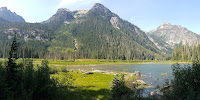
The trail is dusty, with a few muddy spots. The first 3.5 miles are more or less flat, and easy tread in the forest. Lots of thimbleberry bushes. First is the large grassy meadow, then Hyas Lake (grassy too), both quite pretty, seen through trees (usually not immediately by the trail). Along the trail, any camp-able spot had a tent. Soon, enters Alpine Lake Wilderness. Then the trail goes up for 0.6 miles to the junction of Tuck+Robin Lakes. Another flat-ish 0.5 mile to the large 4-way (or rather 2x2) junction with PCT. Two signs here, clearly mark the trail.

Follow the sign to Marmot Lake, slowly gaining elevation for another ~0.5 mile, out of trees, through a lot of huckleberry to the unnoticable Deception Pass, before going slowly downhill in the same thick huckleberry meadow, passing a couple of small mosquito tarns. Then, the trail goes further down into the trees following a branch of Deception Creek, before going up again.

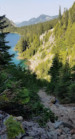
Zigzags, gentle grade, good tread, a few talus fields. At the upper reach, passing the same creek (outlet of Marmot Lake) twice, where you can wash. ~2 miles from the 4-way junction, you reach the junction to Clarice Lake.

Turn left for Marmot Lake. ~0.5 miles you get to the shore of Marmot. However, the trail is in the trees. The slope of the lake shore is mostly steep. Lots of tents here and there, occuping all flat spots.
It was already 3pm. I was worried of finding a suitable campsite at Jade, so didn't stop at Marmot. O told me to look for a flag and ask for Lorenzo (the host of her Facebook event). Going up from Marmot Lake seems like a climber's boot track, requires minimal scrambling in the trees over big rocks and down logs, and then a steep rock gully.

The track is more or less obvious to follow. Above this gully, the grade eases. It plateaus out at a heather meadow with a small almost dried up pond and No Name Lake (a few tents here). Then you get into trees again at a ridge, and the view of Jade Lake blow the trees. Drop down steeply in dust. I reached the lake ~4pm, but didn't take a photo, looking for a camp site. I found a couple of suitable sites, all very small, none very good. O arrived. I hold her that I didn't see any flag, but there's a big group near the lake, she should inquire. Sure that's Lorenzo's group, only no one brought a flag, and he was not at the camp.

We camped not far from them, near the mosquito pond, without seeing them. Climbed down to the lake to clean up, and ate. Some mosquitoes. Tent was wet just sitting lone. Odd. After dinner, we went to the group camp. There were 5 tents + 2 hammocks, 2 dogs. One girl strung Xmas lights between trees. More bugs before it got dark. Could see hikers in head lamp coming back from Dip Top Gap.
I left for my tent ~9pm, because it was getting too chilly to sit outside. Went to sleep ~10pm. Moon was bright, which rose around 9:30pm, so the stars weren't as good as I hoped. Cold night in my 45°F sleeping bag, ~5500'.
9/6, Sunday, sunny. I got up for sunrise. Not much of a sunrise. Took a few photos near the lake, read, and went back to bed.

O wanted to delay going up the gap late, so the snow would be softer. She didn't want to bring spikes, when I offered her Friday night. I brought mine. We headed out ~11am, and said goodbye to Lorenzo's group. None of them planned to go up to the gap.

The lake now has this irrestible baby blue color under the bright sun. Quite walm already. Many folks hanging out in the water. One girl was on a pool safety ring. I chatted with a large Chinese hiking group from Portland. Its leader planned to go behind Pea Soup Lake onto Lynch Glacier.
O and I took a small detour to the other side of the lake looking for suitable campsites. Yes, a few, but no water. One still had some snow left. The lake shore is steep mostly. Shallow at the bottom of Dip Top Gap. Yes, 2 tents there. To get here, there was a steep slippery slope to negotiate. Thankfully, it's short.
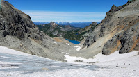
The first half of the gully is rocks, with water running over/under. The upper half is snowfield. Half of the hikers here didn't wear any traction device. I had my micro-spikes on, which made the walk a piece of cake. Great close-up view of Mt. Daniel once you reach the gap, and the blue Pea Soup Lake - why this name, why no glacier color? Lynch Glacier is melting into it. I scrambled a few steps to the right, and found a flat spot to eat my lunch and waited for O. There's no safe way to walk around to Lynch Glacier.
The Chinese group arrived one by one and was looking for the rock to replicate this
Instagram photo. After a long break, I decided to scramble along the ridge to get a better view of the mountains behind Daniel. Met a couple higher who claimed to have found the Instagram rock. They also informed me that their friend went higher.
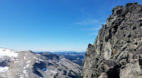
So I continued. After some time I reached a plateau, with some suitable campsites (no water). Above that are black rocks, and it gets steeper and narrower as you go higher. The view also gets better, you could see Rainier above this plateau. You can see 3 other tarns, one has a pea soup color.

There are a couple of airy walks at the summit block that require caution. But the rocks are stable. It turns out I managed to scramble all the way to the top of
Dip Top Peak.
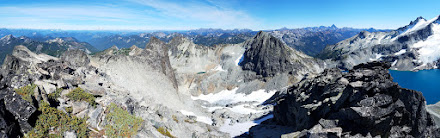
There's no registry here. 360° fabulous view. I didn't stay long here. Took me an hour to get here. Gingerly walked back. Below the plateau, I dropped down too early before edging east. All the Chinese and O were waiting for me. I guess I took so long that it got everyone worried.
No incident going back to the camp. On the way stuffed snow into my water bottle. Lorenzo's group was gone. Already 4pm, we packed up and hiked out. There were still hikers coming up from Marmot Lake. We camped around 6:40pm at a huckleberry meadown near Deception Pass. There was a small pond, but the water has quite some of moss/algae, not the best. More mosquitoes. Warmer. Some fireweed still in flower. Moon rose a little later. Better stars before the moon.
9/7, Monday. O wanted to visit Blanca Lake if we started from the TH near Hwy-2. As a replacement, I suggested
Robin Lakes. We were ready to hike out at 8am, but O wanted to wait for the sun to dry up our tent. We finally got going ~9:40. I picked 2 containers of huckleberries. There were tons here.

We left our packs below the trail junction. I took a day pack with food and water. We headed towards Tuck Lake. Met ~46 backpackers coming down. At Tuck, met another 2 groups. The trail is pretty bad: eroded and steep. I remembered it being a difficult hike, but don't remember why. Now I understand why I never came back here.

Tuck is a nice large forested lake, with an island.

Around Tuck, took awhile locating where the trail was. Look for cairns here. Up and downs. At the ridge before dipping down to Robin Lakes, we took a snack break. 2.2 miles, ~2500', took me a little over 2 hours. Saw only one backpacker coming up. I'm so envious that he has all the space to himself! We didn't go down to the lakes. The view is excellent from this ridge.
Going back down. Took ~1:40 hours. Filled water at Tuck Lake. The water tasted very good. Saw a group of 3 runners. A couple of backpacker overtook me coming out. Back at TH ~4:30pm. Met the Chinese group less than 1 mile from TH. I counted 67 cars still!
Smoke on the way south to Cle Elum (where we filled gas). Terrible traffic on I-90 between exit 70 (Easton) and 25 (hwy 18 to Auburn and Tacoma). Took over 2 hours from Cle Elum back to Seattle. I blame all the hikers from Portland returning home :)
 9/27, Sunday. After a week of rain and wind, the forecast promised a mostly sunny Sunday. Left Seattle in clouds, and hit some drizzle on the way. Hoping to see some fall color (was fabulous last time I was here). The trailhead parking lot, the outhouse, and camping area is beyond the washout. Just a short walk. The new parking area is smaller. Maybe ~10 cars.
 Quite cloudy when we started, a little before noon. We ran into V. halfway to the pass. He was running back already. More brown than yellow and red. I guess it hasn't been cold enough. Still some good good color from Hannegan Pass, going up the meadowy slope to Hannegan Peak, especially later in the afternoon when the sun finally came out. Tons of huckleberry at the first flat plateau ~5500'. Good color. A girl was picking berries with a special tool. Snow started shortly above.
  The peak was covered with 2" of snow. A total winter wonderland. Very pretty. I was wearing, again, below ankle shoes. So had to be careful walking here, without getting my feet wet. Only one person when we arrived. 4 more later. Not crowded.
 View on the top is absolutely beautiful. 360° all the way to Canada. South to Glacier Peak (but we didn't see it, due to clouds). So many peaks.


