Sunday, June 26, 2016

2016.6.26. East Zigzag and Cast Lake

6/26 Sunny and warm (in the high 80s°F). 4 of us hiked Cast Creek trail to Cast Lake and Zigzag Mountain, 2 of whom have never hiked these many miles (13.5), and were quite slow. Rhododendron along the ridges, and summer flowers out near the top.

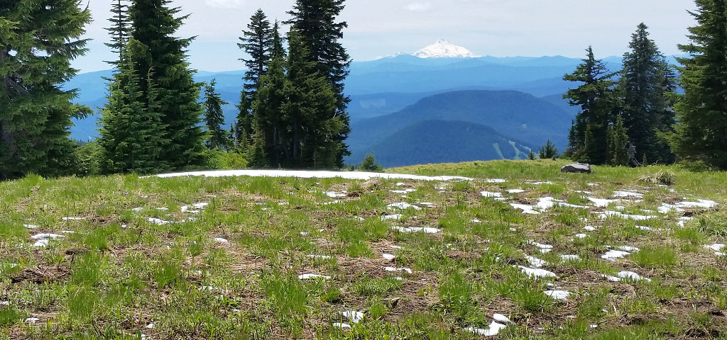
Cast Creek trail is boring. Trees are thin. No view for the first 5.5 miles. It took us some time to find the trailhead beyond a decommissioned road by the Riley Horse Camp (2050'), saw two cascade lily in the process. The trail is in good shape. Many long zigzags, and it's not always going up. The first good view is shortly before the junction of Zigzag trail (5.7, 4550). Rhododendrons and view of Hood, Adams, Rainier, St Helen. More flowers cling to the cliff below. I sat here and read a Moon guidebook, waiting for my companions, almost fell asleep.

At the junction head right, and downhill to Cast Lake, about half a mile and ~200' down. Some avalanche lilies and a bit mud. The lake is foresty when you reach it, hard to take a photo. All of us and 2 other guys huddled in a small water access point. Upon hearing that there's a use trail to "the island", I decided to check it out. It's not an island, a small and semi-swampy stretch connects it to the lake shore. I found a site fit for 2-3 tents in the middle. Not a lot of room. Very overgrown. It does have a nice waterfront access facing my companions. They are in the water! So I decided to get into the lake too. Since I have a "private" shallow water access by the swampy connection, it's easy to strip. I didn't see any fish, like my companions did in the deeper side of the water.

Back up at the junction, one lady decided to turn back. The rest of us continued up along Zigzag trail to East Zigzag Mt (just shy of 5000'). It's short, maybe only 1/2 mile. 
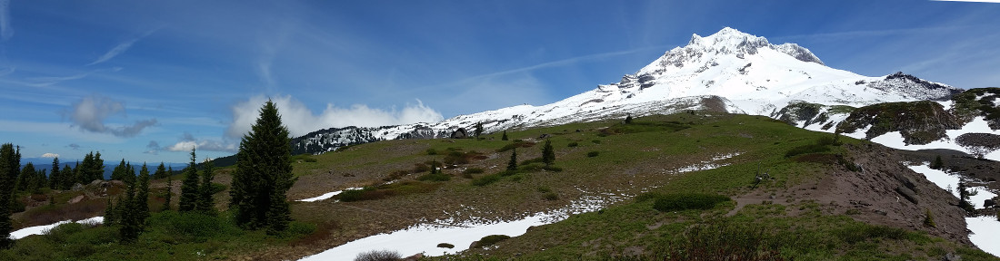
Before the flat top, there's a ridge, which I like the most during this hike. Tons of summer flowers (mariposa lily too), Mt Hood dead front (east), St Helen, Rainier, Adams to the left (north) and Jefferson to the right. Then you hit a sizable campsite. There into and up the trees is the top, with many rocks to sit on. But the views are obstructed by the trees. Continue a bit further is the trail to Burn Lake. A nice ridge full of flowers, and 2 hikers.

Nothing to report on the way down. I had to wait for them again for over half an hour at the trailhead. Got 2 mosquito bites while waiting. Total we encountered 2 runners, 4 hikers, and many fresh horse droppings in low elevation. My phone registered almost 40K steps.

Only an hour drive to Gateway. However, it took me a long time to get home. Trimet problem: no power in downtown, but most buildings had power. There were shuttle buses to ferry people from Rose Quarter stop to Providence Park.

Saturday, June 25, 2016

2016.6.25 Opal Creek and Opal Pool

6/25, Saturday. Sunny. Early start: 5 of us met at 6:45am. Saw a few hot air balloons when going down I-5: there was a Balloon Festival in Tigard this weekend.

Opal Creek wilderness is 2 hours SE of Portland. The easiest approach is the gravel road to Jawbone Flats of Opal Creek Forest Center - a privately owned education facility. Of course, if you are not part of an activity of this facility, you have to walk the gravel road, only about 2.5 flat miles. Hence a lot of people, of all ages, in all outfits. The early start is a good idea. When we drove home at 1pm, the parking was about a mile long. The most notable of this creek is the color and clearness of the water. It's beautiful! Along the walk, you'll see remnants of old mining activities: closed shafts and rusted machinery.

Jawbone Flats is quite large. Housing facilities, an information center with a map posted (closed then), more abandoned machines and cars, a beautiful meadow.
From here, walk 1/4 miles to right to Opal Pool: a narrow gorge, where you can stand on the bridge to admire the rushing water, or hop to the rocks on the other side, and have a picnic. Our hike leader of the day was (maybe always is) in a mood of talking and marching. Thankfully, he tolerated me of walking over to the middle of the creek to take photos (at least twice). We headed back on the south side of the creek: more like a trail, a bit muddy. Many campsites on both sides, and many people are coming with huge backpacks. 1/4 miles to the trailhead, he realized that we didn't even have lunch, so we scrambled to the creek side, and had a relaxing 20 minutes, during which he never ceased talking. Talkative is a good quality when driving: we didn't fall asleep on the way back.

So total about 6 miles, 3 hours fast-pace strolling and 4 hours driving. I'm glad that I came, wish we could spend a little more time there.

Sunday, June 19, 2016

2016.6.19. Paradise Park

6/19. Partly sunny. 4 of us hiked Paradise Park trail, starting from a campground (2800') on FR2639-021. The trail is very gentle and soft, slowly gaining elevation. The first mile in the woods. Then, a lot of rhododendrons in bloom. After the junction of Zigzag trail (~5.5 miles in), started to see minor snow patches, beargrass (no flowers), avalanche lilies together with small trilliums. Shortly after, it's junction to PCT (a campsite here). Trees give away to meadows and snow. Here's Paradise Park Loop trail. Snow was not enough to block too much of the trail. Eventually you can make out where the trail is. Another half mile to Paradise Park loop trail. From here on, it's open and offers great view of Hood, as well as St Helens and Jefferson at times. A few nice but small campsites here and there. From one of them you can see Mt Adams. We ended our hike at Split Rock for a leisurely lunch.

Return as we came. Back at trailhead at 5:30pm. Total about 14 miles 3700'. I'm glad that I didn't bring along snowshoes, unlike my 3 companions of the day.

Saturday, June 18, 2016

2016.6.18. Greenleaf Creek and Aldrich Butte

6/18. Cloudy then rain. 10 of us started from Bonneville Hotspring Resort ($5) in nice cool weather. Well groomed trail, a bit muddy at the moment. Dick Thomas Trail en route to Carpenter Lake (no lake). Right fork, followed the Two Chiefs trail as it winds its way up to Greenleaf Creek (see photo, very small cascades). Greenleaf falls itself is above and we had no view of it. Supposedly you can scramble up to see its splendor. We walked a few hundred yard back to a rocky+mossy opening for lunch. By then, it started raining.

When the rain lightened a bit, we continued back, and then turned north onto the PCT. With Zack's lead, we followed a series of user trails to the old lookout atop Aldrich Butte for great Gorge views. It was clear enough. Continue a tad bit further on the narrow ridge for better view. On the way down, one guy hurt his knee, so we were very slow. I got tired of the pace, went ahead and wait at the parking lot. Then, it poured. I hurried into the resort to avoid getting soaked like the rest of the group.

By the time we got back to Portland, it was sunny! It was only 4pm. Total about 9 miles, 2000'.

Sunday, June 12, 2016

2016.6.12. Whistling Ridge

6/12 Mostly sunny. Pleasant temperature. Hiked with Friends of the Gorge to Whistling Ridge - Buck Creek - Nestor Peak. The goals is to look at the area that would be affected by the proposed Whistling Ridge Wind Farm project. 18 total, including a lawyer (Nathan) and a botanist (Ralph) as guides (both are great, and in good shape). It's overrated as strenuous. About 7 miles, over many trigs and overgrowth. Access Little Buck Creek road. Quite a bit of ups and downs, tired out half of the group. Lots of retired ladies. Views are mostly restricted. Trees are mostly small. A couple of baldy slopes have good view of west (Hood) or north (Adam), and more flowers. Right now, purple Globe Gilia, Yarrow, and Broadleaf Buckwheat. Not many balsomroots are still in flower. Lupines are seeding. The last 1/4 miles is on a logging road, to Nestor Peak. There's a shed on its flat summit.

After the hike, half of us went to AniChe Cellars, just around the corner. On the way, saw black bear on the road, for a few minutes. I'm in the 3rd car behind, still saw the bear well. That's a treat. At the winery, $10 for wine tasting with paired snacks. Seems like a good way to admire the view and the chickens in sun. My driver (a family of 3) didn't want to stop, so we headed back to town.

Driving back across the bridge to Hood River now gives you a good view of the Wind surfers. A lot of them here today, at least 50.

Since it's still early, I bought a beer and headed to the International Rose Test Garden. Sat by the roses with a book until sunset. A very nice and busy place this time of the year. Roses are blooming.

Thursday, June 09, 2016

2016.6.9. Live Monumental Film Tour

6/9 Thursday. 8:30. McMenamins Crystal Ballroom hosted 5 short films by Wild & Scenic film Festival, and Keen Footwear's Live Monumental project. Last year, the yellow Keen RV spent 9 weeks on a road trip, advocating protection of public land, especially rallying for the creation of these 5 new national monuments: Owyhee Canyonlands, SE Oregon; Mojave Trail, southern California (already signed); Birthplace of Rivers, West Virginia; Boulder - White Clouds, central Idaho (already a wilderness area), Gold Butte in SE Nevada. 3 of the 5 short films are about Grand Canyon. I like the one on Arctic NWR: stunningly beautiful. I and many others also signed a postcard for President Obama to protect Arctic NWR.

Maybe 1/3 of the room full (it's a big ballroom). Bar. Even though I was 10 minutes late, the movie hadn't started yet. 3 of the people in the tour were present. A film on the Live Monumental project was shown at the end. Nice composition, but the camera man has a lot of room for improvement, or the crew needs to learn patience, and wait to take a better shot.

Sunday, June 05, 2016

2016.6.4-5 Glacier Basin - Camp Schurman at Mt Rainier

This weekend, the forecast called for 100F in Portland, and 90°F in Seattle. To escape the heat, you either go to the snowy mountains or the coast.

6/4, Saturday. 30 minutes delay due to construction at Bonney Lake. Only around noon, we picked up a wilderness camping permit for Glacier Basin at White River ranger station. This ranger is very friendly and cheerful, unlike the one we met at Staircase last Saturday. Temperature registered at 79° by the car. At the White River Campground (closed for camping) many cars parked there. 81°F. 4230'. People of all ages. Glacier Basin trail starts at the end of the campground.

The first mile is flat. Good trail. Emmons Moraine trail is half a mile spur to the left/south of White River. A few people stopped at the bridge, for getting up the other side is a bit loose. Well worth the short hike along the moraine. Continue a bit further after the end of the maintained trail for better views. You can see (probably get to via use trails) a glacial green lake. View of Rainier and Tahoma is also perfect.

Back on the main trail, continued another mile, snow patches started to appear. Soon all snow. I was feeling very tired for some reason, dripping sweat. The 5 campsites equipped with 2 black bear cans (big like a garbage can with twisted lid), at the edge of the forest, all half buried in snow. About 6000'. A big now-snowy meadow under mighty mountains is immediately beyond the camp. We opted to camp out of the woods, a bit north, on snow, not far from a small stream, with a view of a small pond, and the full glory of the mountains. I washed at the pond, unbeknownst to me that there were at least 2 dozens of dead frogs at the bottom of the pond. Walked about the basin, and to the roaring river. Saw a marmot. Picked up some rocks. I made a small snow mount. Put the rocks on top for seat. Met one couple camping by the bear cans.

Sunset is disappointing, as this is at the east side of the mountains. Western sky is blocked. Woke up at 2am. Decided to take star photos. But clouds came, as I was fiddling with the camera settings. Not cold. But it's cold to sleep on snow.

6/5, Sunday. Blue sky. Still pleasant temperature to hike. Put on crampons and headed to Camp Schumann. Lots of people going there, most of then on skis. Slope is gentle, snow was soft. Easy to make foot hold going straight up. Up and up we went. I was taking a break every 50 steps. Not just my legs, even my arms muscles were sore. The view gets progressively grander, the higher you are. Baker, Glacier Peak, and myriad of green mountains now dusted with snow. Reached the Plow at the end of Interglacier, looking down at Camp Schurman. View is stunning. Tahoma is right in your face. Faintly you can see Puget Sound, and Olympic mountains. There are many skiers on the slope, some were coming down from the top. Amazing to watch. For climbing Rainier, this web page offers detailed description.

Going down is easy. I folded my poles and sat down. This is the longest stretch of wide slope I have ever glissaded down. It was fun. The snow was soft, built up instantly when I slid. At times, I had to use poles to propel the motion.

Back at the camp. Picked up stuff and hiked out. At about 5pm, got back to the car. It registered 81°F just like yesterday. Back to the sweltering hot city, ended a grand weekend on the snow. Why all good things have to end?

Thursday, June 02, 2016

2016.6.1. Nakamura speaks at PSU

June 1st. 5pm. Portland State hosts a lecture by Dr. Nakamura on the invention of the blue LED. He's very humble, talked about his home island, and how small it is. He practically contributed to his invention to lack of resources: both collaboration and apparatus, in his small company, so he had to do everything from scratch. This lecture is one of the PSU's Gurevitch Memorial Lecture Series.