2015/9/26-27. Ira Spring's 100 Classic Hikes of WA, hike #24: Golden Lakes loop. 4.5 hour drive from Seattle. This is a mixed use trail, or more accurately a trail made for bikers. Gentle grade, sometimes the zigzag is so flat that I couldn't tell whether it's going up or down. On Saturday afternoon, I counted 16 motorcycles, 5 mountain bikers, all heading out. On Sunday, I met 15 bikers going in, 9 motorbikes heading out, heard a couple more motorcycles coming in from a different trail near Cooney Lake.
  Rocky trail close to the passes, and dusty (sometimes rutted U-shaped) trails in the valley, and made more dusty when wheels rolled by. I haven't met a single hiker in the 2 days. Did see 2 tents at mid Eagle Lake, not sure if they hiked in or biked in, as well as one guy waiting at the trailhead. Didn't see any horses, but many horse droppings. Once you get to almost 7000', it's magical, made more so by the golden larches. Now is the best time to visit. As a reference, this old trail report has more details, seems buggy when warmer.
 9.26, Saturday. Cloudy in Seattle. The fastest way, suggested by Google (which knows Crater Lake Trail), is via I-90 ‐ US-97 N — WA-153 (Methow Valley highway) — Golden Creek Loop Rd.
  Pavement ends at the turn to Foggy Dew Campground. Do not turn. Continue and turn south (left if coming from Patero) at FR-300 for ~5 miles (to the end, or rather the road becomes too overgrown and narrow to drive on). The gravel is not too bad. US-97 goes along Columbia River: blue water, brown hills, lots of apple orchards, most were already picked. WA-153 curves along Methow River, more apple orchards. Quite a scenic drive.
 Trailhead sign for Martin Creek Trail (2 miles), Horsehead Pass (7 miles), Crater CR TR (1 mile). Elevation ~4700'. It was almost 2pm when we started hiking. I was very motivated, as I could see the golden larches on the top of Foggy Dew Ridge across the valley, almost right at the TH. 15 minutes in, you'll see a trail sign to the right and up for Crater Lake TR, No 416. Maybe next time (it's hiker only). 30 minutes later, at the right junction going up, sign for Upper Eagle Lake (4 mile), Lower Eagle Lake (5 mile), Horseshoe Pass (5 mile). At the left junction going forward and lower, sign for Foggy Dew Trail (9), Cooney Lake (6), Martin Lake (5). At 4pm, first glance of the Lower Eagle Lake. 10 minutes later, there's a great viewpoint fitted with 2 stone benches, excellent photo spot for the Lower Eagle Lake.
  Another 10-15 minutes later, the trail goes next to the Middle Eagle Lake (now a muddy pond, very pretty though). Found 2 tents here. Now larches are more common. But don't stop here. Walk on the hiker only trail, going through meadows with larches, in 0.5 mile, is Upper Eagle Lake (~7150'). It's utterly stunning, under a circle of granite peaks going straight up. Only larches here. A good but cold camping area. Quite windy, and getting dark. We walked back to the main motorway via the lake outlet.
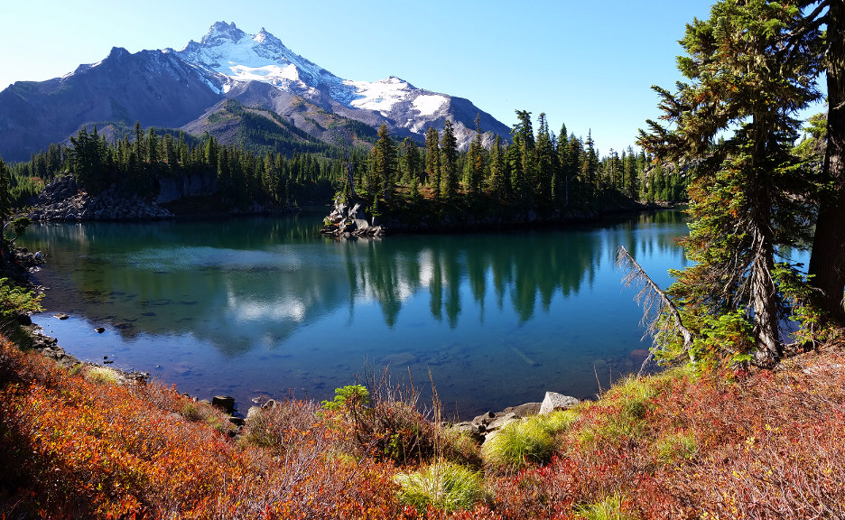
 It's a 30 minute walk to the Horsehead Pass (~7600'). The view is outstanding. You see much better the Lower Eagle Lake on the way. Once at the pass, view to the eastern North Cascades. The setting sun is shining on this side (west), larches are brilliantly lit all along the slope and around Boiling Lake. No wind. The lake was still, with perfect reflections of the golden trees. What a beauty.
 9/27, Sunday. Cold but sunny, not a shred of clouds. The rising sun didn't hit this west side until mid morning. Frost on ground, ice sheet formed on lake edge, my towel was frozen hard. It didn't thaw out until ~10:30am!
We headed out on the trail signed to Cub Lake. Instead of going west, it went south. It went along meadows dotted with larches, up to a knoll, where you can see Mt Rainier. We followed this track until it disappeared. I started going SW hoping to hit the main motor highway. My buddy found a more prominent trail sooner, and followed that one. That's the last I saw of him until back to the car, when I heard that trail also disappeared. As he has no map, he went back the way we came in. Too bad. But he checked out Upper Eagle Lake again in the sun. That's nice. Eventually I hit another faint track, and started following that, which fortunately leads to the main motor highway.
 Saw the sign of "Angle's Staircase", which is not mentioned in Ira's guide, nor at the turn on my GPS map. I followed it, since it's the right direction, after leaving a few signs at the junction. That was a correct decision. It zigzags up over Hoodoo Pass ~8000' (10:50). Before reaching the pass, I met the first person today, a mountain biker.
  The view is grand here. Mt Rainier to the south, many peaks to the west. To the east is the Merchant Basin, but you don't see Sunrise Lake (~7200') from here. Follow the ridge north. Before the trail goes down, it splits again.
 Turn left for 20 steps to the ridge again. Turns out it's a different ridge. There, you see Cooney Lake ~7300' (11:40), the most golden of all lakes. Coming down is steep at first, and very rocky. The trail circles the west side of the lake. By then, more bikers came in, and got dusty. The trail goes more or less flat heading north, but soon it starts long zigzags down. Larches disappeared altogether by the time I hit Martin Lake Trail. Even though it's only half a mile up (at ~6800'), I didn't go. Uneventful: reached Eagle Lake trail at 14:25, Crater Lake trail at 14:56. Back at TH at 15:11.
 Started driving out at 15:30. This time going through North Cascade National Park. Washington Pass is a must stop. Liberty Bell Group (Liberty Bell, Concord Tower, Lexington Tower, Minuteman Tower, North and South Early Winters Spire) is like a gigantic wall as highway 20 zigzag up and around it. Early Winteres Spires are the most impressive. Here's a climbing route to the south arrete. Saw 2 elderly backpacker coming down the slope. Diablo Lake is always a pretty glacier green. Another nice stop would be the multitiered Gorge Creek Falls, 3 miles east of Newhalem, if not for the late hour. With just one gas/snack stop and the photo top at Washington Pass, almost 5 hours later, got back to Seattle.
The full moon to the east was glowing faintly red (lunar eclipse tonight) for almost an hour.
My phone registered ~24400 steps on Saturday and ~36000 steps on Sunday. So almost 20 miles. Drove ~500 miles. A great fall color hike, just a bit too far. Next time, I shall stay an extra night, and visit Sunrise Lake, and maybe do a day hike on the way back in east North Cascade.