 Saturday, 8/16, 6 of us drove through clouds, but arrived at the busy (~50 cars) Whitewater Trailhead in the sun at ~11am. Stopped by Droit ranger station: closed for weekends and holidays (why? defeats common sense).
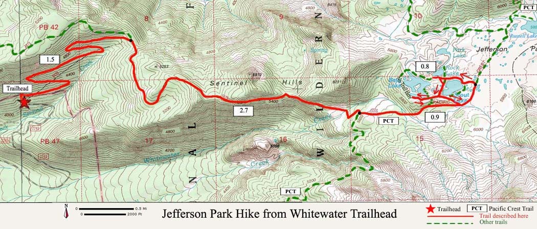
 Easy grade through old-growth forest. At 1.5 miles turn right (or rather go straight) at the junction. A wooden sign for Whitewater Trailhead. The trail becomes more rocky and dusty from this point, but not bad. There will be views to Mount Jefferson from to time and pockets of flowering meadows. At mile 4.0 there's Whitewater Creek crossing - your first water source. Right now, it's passable by all. ~0.2 miles later, turn left at PCT junction, which crosses 2 small creeks on a bridge and a couple small meadows. Soon the trail levels (or slightly lowers) when enter Jefferson Park, and a couple of rangers there to prevent you from taking short cuts. There're myriads of small paths, leading to a campsite, or nowhere.
 My original plan of Bays Lake is fully occupied. It's lovely. Maybe on a weekday. Now it's too crowded. Finding a campsite big enough for 6 tents is a challenge. I went around a couple of lakes, eventually claimed the middle of the 3 sites on the southern shore of Russell Lake by scattering my stuff there. It took some persuasion to move the others, as 2 of them had already set up their tents. From Scout Lake (the first one you encounter), Russell Lake is ~0.8 mile north on PCT. There's only 1 site on its northern shore, and I was just 10 seconds late for it. I'm quite happy with my choice, view of the water and Mt Jefferson, just not at the same side. By then, it's past 4pm. At about 7:30pm, Veda agreed to go to the northern shore to see sunset.
We had an unhappy episode of snoring vs. complaint around midnight. A surprise when you go camping with strangers.
 Sunday, I woke up Jennifer and Veda at 5:50am, and walked again to the northern shore to see sunrise. The same guys with tripod last night were there too at the same spots!
  After a slow breakfast, 2 of us went home. The rest hiked up with me to Park Ridge along PCT. It's definitely worth the trip. Only ~2 miles to the top of the trail. Great view and more meadows. Some snow too. View Hood to the north, and Russell Lake + Jefferson to the south. Met a girl PCT through hiker doing south-bound solo. What a courage. A couple who just turned 30 the previous day going north bound. The girl was on the trail for 4 months by now. The guy joined her 2 months ago. I offered them some fruit peel, and was happy that they accepted. All 3 of them seem to carry less weight than my backpack for 1-night! Uneventful getting back to camp. The ladies decided to cook for lunch! We then hiked out.
Total ~15 miles for 2 days, ~2500' gain/loss. An easy weekend. Flowers are on their last legs. Quite some huckleberries to pick. For other hikes in the area, click here.
Direction: Highway 22 east of Salem at milepost ~60, go left on Forest Road 2243 (Whitewater Road) for ~7.5 miles to its end. Pit toilet, a picnic table, a trash can.