Saturday, October 31, 2020

2020.10.31. Blanca Lake

10/31, Saturday. Partly sunny and warm (high in the 50°Fs) this weekend. Perfect for hiking. Blanca Lake is one of my favorite lakes near Seattle, due to its glacial color. We arrived after noon. Squeezed in between two cars, as the parking lot was full, and a few cars spew out along the road.

ridgeThe trail is boring, at least the first 3 miles before getting to the ridge. Easy and well maintained. Not much fall color on the trail to speak of, better on the drive here. Some color on the ground. The fallen leaves are mostly brown, rather than yellow or red. A lot of people coming down as we hiked in. There was some leftoever snow from last weekend near the ridge. I didn't bother with micro-spikes. Didn't have much problem. The snow on trail was treaded down, if not too muddy. Could see Glacier Peak and some other peaks. Near Virgin Lake, all white, looking like fat floating on top of soup, a young lady asked if it were Blanca Lake.

Blanca LakeThe trail was quite muddy, and steeper on the way down to Blanca Lake. The color today was fainter, maybe due to the thin clouds. Alwasy lovely. Had my sandwich on the rocks before going down to the waterfront. A couple was fishing, and posting photo with their catch. When we returned to the lookout rock pile, everyone was gone.

A solid 2 hour drive (~10 miles on potholed gravel road). A beautiful day and and easy hike to a beautiful destination.

Sunday, October 25, 2020

2020.10.24-25 Spider Meadow snow camping

NOAA weather forecastLured by the sunny forecast, but concerned of the cold, I set out to try some winter camping tips:
  • air pad on top of closed-foam pad. My Big Agnes AXL Air is one of the lightest (9.6oz), but not insulated. Worked well on the Thermarest RidgeRest (9oz). I didn't feel the frozen ground.
  • one sleeping bag inside another. I put my Phantom 45°F inside my Igneo 20°F, both I have owned for a number of years (2016, 2014), so not as warm as new. I stayed warm throughout the night (may have gone down to ~15°F/-10°C.
  • put water bottle upside down in fluffy socks.

Phelps Creek TH10/24, Saturday. Cloudy. The Chiwawa River road was snowed in during Friday's storm. Over 20 miles. Slow going. When we arrived ~13:30, the car showed 34°F (the last time I came to Spider Meadow, it was 94°F). There were 3 other cars. One had a foot of snow on top. I put rain pants on top of my thin hiking pants, put on gaiters and microspikes, walked into the snow. The snow was soft. Footsteps to Carne Mountain high route. We were breaking trail. The young trees bended over the trail under heavy load of snow, blocking the way. Lots of animal footprints on the fresh snow. Maybe a cougar. Lots of bird and rabit prints. At least one deer. Near the boundary of Alpine Lake Wilderness, we saw some footsteps, and then 2 hunters with their tent. They told us that Spider Meadow had one foot of snow. Not a piece of good news. We didn't bring snowshoes.

No more footprints after meeting the hunters. We arrived at the meadow ~5pm. The 5.5 milea took longer than usual. Light snow was falling. Gloomy all around, but pristine. We quickly put on warm clothes, and pitched the tent. I had trouble staking the tent to the frozen ground. The snow was too soft to anchor the stakes. Had to look for rocks. Forgot to bring a Mylar blanket. Then we fetched water to cook dinner. My boots are thin. Once I stopped walking, my feet quickly got cold, even though my upper body was warm. I brought many layers of clothing, and a Windstopper hat. After dinner, cooked water to put into Nalgeen bottles and into the sleeping bags.

Spider Meadow 10/25, Sunday, partly sunny. Brillant stars once the clouds lifted at night (the moon set ~midnight). Very cold in the morning. Missed the sunrise. Didn't get out until the sun reached our tent through the trees. Cooked breakfast. Again, my feet froze while eating. Only after hiking a mile or so later, they warmed up.

Headed towards Spider Gap. Guessing where the trail was by slight depression on the snow surface. Snow was up to my knee high some times. My partner was breaking the trail. One section of the trail, there were icicles broken above and falling towards us. Near the notch, we were caught up by a group of 4 skiers. Yes, all the way to the junction to Phelps Basin, would be perfect for skis. It's beautiful here. Still some golden larches. It was noon. After a lunch break, we headed down, instead of going up the glacier to the gap. We wanted to get on the road before too dark. On the way down, met another group of 3 on skis.

A bit easier on the way back. We followed our own track, treaded down further by the 7 skiers. Packed up and headed out. Nice sunset near the trail head. Met another single skier. 3 different cars at the TH. ~5:30pm.

The snow on road was now frozen. The car showed 29°F. Slow going. Once passed Stevens Pass, the temperature rose above freezing. A successful winter camp.

Saturday, October 17, 2020

2020.10.17. Navaho Peak

10/17 Saturday. Day hike to Navaho Peak - a highlight of this spring. View is not as good as in June (slightly less snowy), no flowers, but the few larches are a good compensation. No dust is also nice.

We only decided on Friday evening where to go. From a trip report of Thursday, up to 1 foot of snow, we prepared for cold and wet condition. But I'm too lazy to bring snowshoes, knowing that if it were needed, it would be only ~1 mile. Thank god that we didn't lug the snowshoes up. The snow had melted to just a couple of inches.

Mostly sunny in the Teanaway. A few clouds, warm for October. Perfect hiking weather. I left home at 6am to take the first bus out east, met V at TC. Drizzle on I-90 until Snoqualmie Pass. A lot of camping (hunting?) parties camped along the forest road. We arrived at Stafford Creek TH ~8:45am. The car said 39°. Put on gaiters for the potential 1' snow. When we started hiking (just before 9am), the parking lot was full.

Navaho PassThe trail is easy to follow. A couple of fallen trees to walk around, and a couple of easy creek crossings. Saw a camp with 3 tents and campfile by the creek. We were not fast: haven't hiked for 2 weeks. Within the first half an hour, we shed a layer, V had to ran back to fetch sunglasses, and then ran back to look for his hat. So I had plenty rest. Didn't even sweat. The temperature was pleasant, and I was in T-shirt. The meadow was covered with a thin layer of snow. Not much to look at. A tent here. I cringed seeing the muddy boottrack cutting across the meadow. I don't want to damage next June's shooting star. We skirted around the meadow, following the trail in melting snow. Above the meadow, it was more exposed, so a bit windy. We took a break to put on a layer. V insisted a longer break to refuel. I went ahead and waited for him at the pass, for a better view.

Navaho PeakThe view is, of course, lovely with the larches. Most of the yellow is on the north slope of the pass, and to the right side of the ridge. However, not a lot of larch trees. On the way up to Navaho Peak, the trail was steeper, more snow. But no need for micro-spikes, nor snowshoes. No more larch. The very top rocks were bare of snow. So we can sit without getting wet. I finished my lunch here, bathing in the view. Had to put on my softshell, due to wind. Not very cold. We stayed over an hour, checking the peaks. It's especially nice to locate Little Annapurna, which we just climbed 2 weeks ago. One couple recommended climbing Stuart in Aug, and Dragontail in June. V chatted with everybody at the top, even got the phone number of a girl who's new to WA, now works at CWU's international student office. Increasing clouds.

view towards Navaho PeakOn the way down, saw the Ellensburg girl (Shelby) practicing with borrowed ice crampons. We stopped, and V adjusted her crampons, and gave her a long lesson. The rest of the descent is uneventful, a bit boring. We reached the car at 4:15pm.

V drove very fast. I was dropped off at the bus stop ~6:10pm, didn't wait long for my bus (runs every 30 minutes before 8pm). A pleasant and easy hike. Didn't feel the over 4000' elevation gain. 39K steps (including walking to bus stops).

Sunday, October 04, 2020

2020.10.3-4 Merchant's Basin

Had wanted to visit the Golden Lakes again since my last visit in 2015. It's a long drive (4.5 hrs without stop). This time, decided on a different approach. The weekend is sunny, despite of the widespread haze. I looked forward to the trip, even though my legs were already sore.

10/3, Saturday. I was picked up from home at 9:30am. We drove along I-90 via Wenatchee. Sunny, but getting more and more hazy around Wenatchee and north. Stopped at Wenatchee River park for a restroom and snack break. Ate lunch at Foggy Dew Creek TH. FSR 4340-20 past Foggy Dew Campground is gravel with potholes, but not terrible. ~14 cars at the TH. ~3400'.

Foggy Dew FallsIt was warm. Luckily, the trail is mostly in the second growth forest, slowly gaining elevation. Alternating smooth and rocky. I opened and closed my umbrella many times. Fall color was nice. However, dry leaves and dead logs made me worry about forest fire. You can see Foggy Dew Creek from time to time, but mostly never next to the water. About 3 miles in, this waterfall is signed, not at the same place indicated on the map. In about another 2 miles, a 4-way trail junction in the woods. We took the wrong turn left onto a trail that crosses a creek. This trail (Navarre) doesn't exist on my Gaia map (exists on FS map). Only on the way back, we found its sign on the ground.

Merchants BasinContinue straight (on Martin Lake trail), soon, the trail goes up steeply for ~half a mile. Luckily it's on the east facing slope, so mostly in shade. Then the grade eases, and we started to see larches. Another half a mile later, we entered a large meadow. I smelled smoke, was wondering if we were coming upon a forest fire. Saw this tent with camp fire. I don't understand why people want to set fire on such a dry and warm day, with a high risk of causing forest fire: dry grass everywhere. We have arrived at Merchant's Basin. Very pretty. We like it so much, that we decided to set up camp here instead of at Sunrise Lake.

Found a spot close to a tiny creek, ~6950', in a clump of trees, looking over the basin. After setting up the tent, walked up to Sunrise Lake (7228'). Saw a large family with a bunch of kids, another tent by the lake outlet. 1 tent on the southern end of the lake. An old couple was collecting firewood. OMG. Again! The lake is a good size. A lot of larch trees here. The ground was covered with yellow needles. Very pretty.

The night was not cold. I fell asleep shortly after eating dinner. Total today: 9 bikers, and 4 tents.

10/4, Sunday Woke up early. Ate 2 breakfast bars, and went up to Sunrise Lake again. The lake was still in the shade. The larches on the way were bathing in the sun. The ground was covered with golden needles. 2 little girls were playing barefoot.

Packed up and hiked up to Sawtooth Ridge. Very beautiful all along. At the next junction, a pass, you can see Cooney Lake below. We set down our backpacks, turned left towards the ridge. Excellent views, but windy.

To Switchback MountainAfter my sandwich, we scrambled up along the ridge to the top of Switchback Mountain. There was someone there already, with a camera and tripod. The view is splendid all along the ridge. Too many peaks that I don't know the names. Scrambled down the mountain closer to the trail.

Down Cooney Lake we went. The best larches. Golden everywhere. Relaxed and ate my 2nd sandwich, before hiking out. Saw more bikers, one motorbike, a few backpackers. Back at the car ~3:30pm.

Driving back via Hwy-20. Stopped at Washington Pass' lookout, admiring the granite peaks and some golden larches.

Next time, maybe try Foggy Dew Ridge trail to make a longer loop.

Friday, October 02, 2020

2020.10.2. Little Annapurna and Enchantment Lakes

map10/1, Thursday, 中秋. Due to the extreme popularity of the Enchantment Lakes, we decided to take Friday off. This time, I decided to tackle Little Annapurna, and go in and out from Colchuck, so no need to deal with car shuttle. Around noon, after the latest forecast told me "widespread haze", I almost bailed out. Fortunately, my hiking buddies are more determined. Three of us met in Bothell at 6pm. Camped along Icicle Road, the same spot we camped in June. There was a car there already, but no tent. My two hiking buddies also slept in the car. I had the camp area to myself. Full moon was bright enough that I could set up my tent without headlamp.

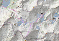
10/2, Friday. Up at 4am. Packed up. Arrived at Stuart Lake TH (~3400') at 5:10am. Breakfast, bathroom, wilderness permit. Started hiking ~5:50am, with headlamps on. We were obviously not fast, were passed by at least two parties. Sun rose on our way to Colchuck Lake.

Going around the lake took awhile. Saw a couple of larch trees (only ~5600'). After most of the boulder hopping, took a longer break at the southern shore of the lake. All was still in shade. Going up Aasgard Pass in the shade is good, because it's steep. It's the west slope, so morning is good. The snow and ice of last weekend had all melted. Took an half hour break at the pass (~7800'), to dry our sweat. No wind at all. Warm.

Isolation Lake is probably my favorite here. This year, less snow and ice, so not as dramatic. Still gorgeous. This time, we took the middle stretch between the lakes. Taking many photos, slowly moved on. The next pair of lakes have no names.

There's no obvious trail to Little Annapurna. Cairns here and there, totally unnecessary. The slope is gentle, choose any path. An easy scramble. The top is practically flat. You can probably camp here if there's snow. A little bit of snow on the upper reach, which I filled my water bottle. The very top (8458') is a few boulders. I couldn't find a registry here. Can see Rainier (hazy) to the south, jaggard peaks on both sides of Crystal Creek. To the north is the Enchantment zone, but couldn't see the lakes, until you go down.

Back to the main trail. On the way, good view of Crystal Lake. Met two young rangers with a shovel. They are on a 4-day shift. We continued downhill to Inspiration Lake, where Y decided for a swim, and V and I walked around to Perfection Lake. ~7100'. Larch is more consentrated here in the lower basin. 3 of us regrouped and hiked back out ~3:30pm. I wanted to be back at Aasgard Pass by 5pm, so we could have ample day light going down the pass. We were back at the pass ~4:45, and took the last long break, and headed down at 5pm.

Going down is worse than going up. I took a wrong boot path and had to scramble down a big rock with water running over it. Dangerous. Need to keep south (left) first, and then keep right. Towards the bottom, need to keep left again, cross the creek. Otherwise, too bushy. Eventually down at the Colchuck. Going around the lake, we lost the main trail a couple of times, in the dark. It's a problem near camping area: too many side tracks. Once we left Colchuck, all was smooth, just the 4 mile trail felt a lot longer in the dark. Met the last backpacking going in at 9pm!

We reached the TH shortly after 10pm. The parking lot was bustling with people and cars. A couple of tents in the full parking lot. Quite a long line of cars already lined up the road. Drove by Snow Lake TH, also full and spilled out. On the drive back, I couldn't keep awake. Back at home at 1:30am!

According to V's Garmin In-Reach, we had hiked 16.58 miles, 6786' elevation gain and loss. Intense!