3/10, Thursday. Left work early for the airport. Landed at SLC ~7:30pm. Drove ~4 hrs to River Canyon Lodge at Moab, a small sprawling town.

 3/11, Friday, cloudy. Up ~7:30am. Breakfast. Drove 10 minutes north to Arches National Park visitor center (opens at 8am). Obtained a hiking permit for Fiery Furnace. Had to watch a short instruction video first, and answer some questions. ~26 min drive. Did a loop, maybe 2 miles. No trail. Scramble. Quite fun. http://www.nps.gov/arch/planyourvisit/fiery-furnace.htm.
  Delicate Arch Trail (3 miles RT) is a boring trail to a fabulous destination. The setting of the arch is also beautiful. You can see the snowy top of La Sal mountains through it. Lots of people of all ages. At the beginning of the trail, there's one rock art of goats, and the remnant of Wolfe Ranch, and a creek, yes, with water.
 Did a couple photo stops. Park Ave is most impressive. Being the first main viewpoint of the park, it sets the expectation high. Balanced Rock looks quite safe.
2 hour drive to Canyonlands' Needles District visitor center (closes at 4pm), after a short photo stop at the Newspaper Rock. We'll be camping here for the next two nights.
 Filled water (tastes chemical). Inquired water situation on our route. Bought a disposable travel toilet (poop bag) for $3.5. All solid waste, toilet paper and trash needs to be carried out. Did a photo stop at Big Spring Canyon lookout, before parking at Elephant Hill TH. Started hiking around 4:20pm, carrying 8 litres of water + 2 small cans of beer. Headed straight to our campsite (CP3) in Chesler Park. A bit short of 5 miles, but it took longer than I expected, due to the terrain and the distracting beauty of the surroundings. Sunset at 7:20, just as we entered Chesler Park (on the way saw the group camping at EC1). Fortunately, the clouds made a fabulous after glow which lasted quite awhile. Set up my tent at the designated spacious site (probably can fit 4-5 tents) nestled under huge sandstone boulders that define Chesler Park. Cloudy and windy at night. Stars were not optimal. Sand flew through the tent mesh.
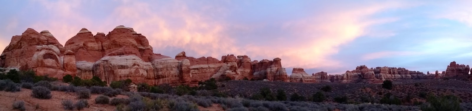
My phone registered 29k steps today.
 3/12, Saturday, sunny. Up at 6am. Not much sunrise: clouds were blown away by last night's wind. Walked back to the marked view point at the north entrance of Chesler Park. (Not worth the effort, unless you don't walk into the park).
 After breakfast, day hike Joint Trail - Devils Pocket loop. ~7.5 miles. Followed cairns carefully. Chesler Park is truly beautiful. Flat, grassy, colorful "needles" of all shapes and sizes. Be sure to walk up the short spur signed viewpoint at the south side, about 0.7 miles from the campsite. You get an especially grand view of the Park. The Joint Trail has a long stretch of walking in a straight crack in the rocks. Barely wide enough for a backpack. Devil's Pocket is a miniature Chesler Park. Lovely. However, DP1 site is tucked away among rocks without a view. Had lunch just outside of DP1 admiring the surroundings.
  Half mile north, used Devils Kitchen's vault toilet (no TP). There are 2 outhouses here at the end of a sandy dirt road. This is a vehicle campground. Head east from the eastern vault toilet. In about 2.3 miles hit the Chesler Park trail of yesterday. This north section has view to distant snowy mountains.
 Back at camp, picked up empty water bottles, headed towards Druid Arch. The cutoff trail to Elephant Canyon requires some scrambling. Again, be sure to follow the cairns. Super fun. Once down at the canyon floor, hike south (right) along sand wash. Canyon walls are tall and narrow, very different from the morning hike. A little over a mile later, reached the spring filled rocket ponds. Filtered 1 gallon. Followed the water for awhile. One of these ponds is big enough for a short swim.
  Today, back at camp early enough to wait for sunset. Alas, too clear of a sky. Stars were great, even with a shining 30% moon. Practiced different ISOs and shutter speeds, to catch the starry sky with the outline of the rocks. I woke in the middle of the night by cold feet.
My phone registered 49k steps today.
3/13 Sunday, cloudy. Pack up and hike out. Checked out Squaw Flat Campground. Quite nice and spaced. Washed at the visitor center. Grab lunch at Moab. Drove another hour to Canyonland's Island in the Sky District.
 Photo stops at Shafer Canyon Overlook, Green River Overlook, Buck Canyon Overlook. Grand View Point is epic. Hiked from here to the very end. About 1 mike. All views of this district is grand, expansive, seeing cracks on the earth.
  Last, walked towards Murphy Point, and camped near an old parking lot at about a mile in, mostly flat, with view of Green River and many cracks in earth and canyon walls beyond. Pitched my tent. Then walk to the point at the end of the plateau. Another grand view. Back to camp for dinner and waiting for sunset. My permit says Murphy Point zone. No designated sites. The problem here is that the ground is rocky. Tent stakes cannot be used. Somewhat windy too. So the only way to secure the tent is tying every corner to rocks.
My phone registered 26k steps today.
 3/14, Monday, cloudy. Up at 5:40am. Packed out quickly without breakfast. Walked back to the car with headlamps. Moon has set already. Sky was still bright with stars, marred by some clouds. 2 other cars at the trailhead. Odd. I got the only camping permit here. Drove to Mesa Arch for the 7:30 sunrise. There were 9 cars already at tge parking lot! Walked to the arch with a row of people and there tripods tightly packed in front! Almost impossible to squeeze in a shot. It was still dark at 6:40am! Waiting on a nearby rock for the sun to rise, eating dry food as breakfast. Not cold, maybe 40F.
 Drove back to Arches to hike the Devils Garden lollipop loop. About 7 miles. Lots of people. Slow driving, as a bicycle event was taking place. Started hiking 9:50 finished 12:40. Lots of people. Saw Landscape Arch (saw a rabbit nearby), Partition Arch, Navajo Arch, Double O Arch, Private Arch.
  The arches are okay to view, the loop trail itself is more entertaining. Scramble at times, ridge walking others. Giant organ pipe like rock walls stacked together. For a clockwise loop, the last mile is sandy without shade, is most tiring. Great views and fun at many parts. In comparison, Fiery Furnace can be ignored. Not sure why it requires a permit.
Back at Arches visitor center for cleaning. Headed to SLC ~1:15pm for 8:10pm flight. 2 gas stops and 1 rest stop (at Tie Fork rest area on hwy-6). Snowed. Arrived at the airport at 5:50. SLC is not busy, or super efficient. No wait at security check. Back at home at 11pm.
My phone registered 25k steps today.