Monday, 9/17, a late start. By the time I reached Longmire wilderness center, it was already 4pm. 77°. I405 exit to 167 was very slow, and 161 at Puyallop was slow. Had to wait after a couple who inquired trails at Paradise in detail, undeterred by my waiting. All backcountry sites are available today on the bulletin board. Since I was 3 hours behind my plan, I asked for Lake George for the first night and Klapatche Park for the 2nd. The ranger told me water was still available at Aurora Lake, but it was dirty. Called to report my itinerary change at the Longmire Inn: there is a single payphone next to the restaurant. $1. ~5 seniors sitting on the porch watching Mt Rainier. By then, the late afternoon sun has finally made it visible. On my way here, it was too hazy to see the mountain at all. I had my late lunch, washed fruits. Headed back to Westside road. Wide, gravel, but in good shape except some big potholes once awhile. Met 1 car coming out, passed 2 cars. At the road block ~3 miles later, ~4 cars parked. No view on the road.
 5pm, I finally started my hike with a bike. My bike ride lasted less than 5 minutes to a washout. A single thin log is placed for foot passengers. I had to wade in the shallow water pushing the bike. At least it was short. However, I was such a lousy biker, that I wasn't able to peddle faster than I walk or even mount the bike. It tired me more than just walking. So pretty much I pushed the bike all the way for 1.5 hours (3.8 miles). The road is along Tahoma Creek, full of rocks and logs, wide, not much water. Occasionally you can see part of Rainier, but not at the old Tahoma Vista parking area.
 Locked my lone bike on the rack at the wide Round Pass (signed 4000'). Lake George trail is behind the rack. Walked up there in ~25 minutes (signed 0.9 mile, and 2 miles to Goat Lake trail).
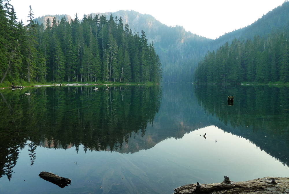
5 big sites on the left side of the trail, on the hill next to the green lake, but no view of the lake. 1 group site on the right side of the trail. A good size open shelter, a locked ranger's cabin, a bear pole. 2 toilets. Mt Rainier was getting really red and pretty, but too many trees blocking the view. I put up my tent first at a flat place near water. Quite a lot of insects huddling in the air, but they didn't bother me. Considering I was the only one for miles around, I later decided to move uphill to a camp site, in case an animal decides to pass my tent to have a drink. It's a pity that I arrived one hour too late to watch sunset from Gobblers Knob. It gets quite dark by 8.
9/18, Tuesday.
 Up at 6:30. Hiked to Gobblers Knob before breakfast. Signed 1.6 miles. Passed a small meadow of Corn Lilly, a pond, many dead avalanche lilies. At 1.2 miles, junction to Goat Lake trail (another 1.1 miles to the lake). The sun rose as I walked. By the time I reached the locked lookout, the sun was as high as the summit of Rainier. The 360° view is still grand: layers and layers of light blue distant ranges with a pink tint. Mt Ste Helens was faint. Mt Rainier was already too bright for a photo. Sunset here should be prettier. The fire lookout was built in 1933 by the Civilian Conservation Corps. After WWII, aerial surveillance became the primary method of spotting fire. These lookouts are still used occasionally. Mt Rainier currently has 4. I was back at the camp at 8:40. Cooked a pack of Korean instant noodle and sweet oat meal. I added salt instead of all of the spicy soup base. Interesting combined flavor. Packed and headed out at 10:00.
Back at Round Pass, I tied some garbage and rain fly to the bike to shed a couple of pounds. There's a Marine Memorial site here, with small flags and a big sign listing all 32 died in plane crash on Tahoma Glacier. Met 2 day hikers here. Headed down to the South Puyallup River trail. At 0.6 mile, it reconnects to Westside road. Turn right and continue on South Puyallup River trail towards Wonderland Trail (in another 1.6 miles) and regain elevation.
 1:10 hour (~2 miles) after leaving Round Pass, I hit the Colonnades to the right. The ~hexagon columns run for a bit until the South Puyallup camp sites. Andesite? They go straight up. Quite interesting. The river water is quite muddy here. This entire trail is in the woods, with cool breeze. My GPS took forever to lock.
 Joined Wonderland trail 2.2 miles from Round Pass. (Signed: Left: St Andrews Lake 3.2, Klapatche Park Camp 4.0, Right: Emrald Ridge 1.8, Devil's Dream Camp 6.7.) Crossed the big bridge over the river, with a partial view of Rainier. Overgrown in parts. Took me over 2 hours to get to the lake. As the high noon sun shined on the dry trail, I was getting tired. In an hour, caught the first glance of St Andrews Park and Mt Rainier. Flowers were all dead by now. Blueberry leaves were turning red, but almost no berries. Met 2 backpackers coming down from North Puyallup camp, who told me there was no water at Klapatche Park. Continued up to a ridge and Rainier disappeared behind hills. Then walking downhill. Slopes of dead lupines. At 2pm, I reached St Andrews Lake, shallow, small but clear, with the reflection of Rainier. There were still 2 small patches of snow left, but hard as ice. Had lunch with melting pate and vegetables that were starting to smell in the heat. I decided to rest here until sunset and cook my dinner here (cook my veggies) before heading to Klapatche Park for the night. 1 backpacker went by the lake at 4. At 4:20, I followed a trail on the opposite dried shore, up to a slope. Found a place for tent with nice view. All along the short and steep trail was withered lupine. Started cooking dinner at 6pm, then had a bar of chocolate, brushed my teeth, before packing all up and waited for the photo moment at 7pm: the mountain was beautifully lit.
 Now hurried down to Klapatche Park, 0.8 mile further. There is a ledge a bit north of St Andrews Lake to take good photos of Rainier and a deep rocky valley draped with thin waterfalls. The withered densely flowered slope. Klapatche Park is small and flat. Almost dried Aurora Lake still offered a bit of unclear reflection of Rainier. 4 big sites on the west side of the lake/trail, reasonably obscured from each other. 2 were already taken. At ~8:30pm, I went out sat at one of the logs by the trail next to the camp, trying to take a photo of the fading Rainier against the starry night. Failed. Absolutely beautiful though. Not a single cloud. Myriad of stars, clear milky way and all. The other 2 campers also came out: old buddies out hiking for 5 days. They go backpacking every September for 13 years. They told me that at South Puyallup Camp, there's a creek towards Emerald Ridge ~1/4 miles away. The creek that fed to Aurora Lake was bone dry at the moment. And last night all sites were taken. So the board at Longmire's wilderness office wasn't updated during the day.
 9/19 Wednesday.
 Same, warm and hazy. Packed, retraced, dropped my backpack behind the Wonderland sign and started my dash to Aurora Peak shortly before 7am. Only 0.3 miles, but 500' gain, overgrown trail. By 7:10 I was at the top of Aurora Peak, out of breath. Mt Adams and Mt St Helens were clearly visible. Layers upon layers of silhouette. Didn't need to rush, the sun didn't reach the southern ridge until 7:30, then only at 7:45 did it shine upon me. Klapatche Park was in the shadow until 8am.
 Cooked a big breakfast at St Andrews Lake. Left ~10:20. reached my bike ~13:30. A group of noisy junior high students came out of Lake George trail with 2 chaperons. I'm glad that I wasn't camping next to them last night.
 Repacked, road the bike back out. This time, gravity did all the work. Took only ~20 minutes to the car which was baking in the sun. Drove back to shade at the turn off, rest and drank. It was 79°. Heading back to Seattle at 3, hitting all the traffic:(