
10/6, Sunday. Sunny. 8:30-16:00.
CUGOS fall event. Organized by
The Cascadia chapter of OSGeo, a day of presentations and workshops at CSE2 auditorium (4th floor) in UW. However, the workshops were scheduled at the same time, so I only could attend one. Here's the note I took. What I liked are marked with *
8:40
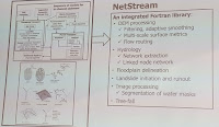
Geo Exploration Simplified with Elastic Maps*
Nick Peihl https://ela.st/cugos2019
SDE on geospatial data and visualizations at Elastic.
Elastic map search: 18 zoom., GDAL support Elasticsearch Driver
ogr2ogr -f ElasticSearch
base map tiles: OpenStreetMap
backend database: https://lucene.apache.org
Pelias Geocoder
reference: https://www.elstic.co/products/maps
9:00
Challenges of building a traffic simulation on open GIS data*
Dustin Carlino,
Project A/B Street
A/B Street is a traffic simulation game aiming to explore how small changes to road infrastructure could improve commute.
Take aways:
1. use separate phases (do not reparse OSM every run);
2. RawMap: stable IDs as we delete/split/copy things;
3. Cross-map IDs ...?
9:20
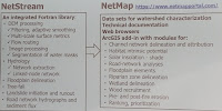
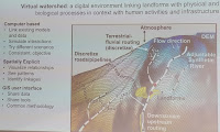
Programs for geomorphic analysis
Dan Miller, TerrainWorks, Inc; dan@terrainworks.com
NetMap Portal: a large library of analysis tools, all open source, and all in Fortran. Windows only
DEM processing: filtering, adaptive smoothing; multi-scale surface metrics; flow routing
Image processing: segmentation of water masks
Hydrology: network extraction; linked-node network
Floodplain delineation
Tree-fall
Landslide initiation and runout
Road network hydrographs and sediment flux.
9:40
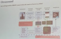
Orcamap: an open-source mapping system for orcas
Scott Veirs, Orcasound
Dr. Veirs is chair of the marine mammal work group within the Puget Sound Ecosystem Monitoring Program.
Orcamap enables sighting and acoustic network coordinators to input, vet, and visualize observed locations of endangered southern resident orca in real-time.
10:00 break
10:20 Lightning Talks
⚡
Lessons Learned from Teaching GIS in Vietnam
Robert Catherman, Medrix
Author of open source GIS curriculum for ESL students Volunteer working with MEDRIX in Vietnam for 20+ years UW alumni in Atmospheric Science
⚡
Map Quality Measurement (MQM): US Cities Road Data Quality on OSM
Monica Brandeis, Critigen, Monica.Brandeis@critigen.com
https://osmquality.io
PHD on crowdsourced mapping projects after many years experiences in GIS and Remote Sensing fields.
MQM initiative started in 2018 to establish a standard methodology and metric to evaluate OSM road quality and prioritize map error hotspots in US.
MQM applies open source ‘atlas checks’ to OSM road data in 51 US cities, ranks them, and creates vector grid layers to show the map quality in each city.
The quality can be weighted by social-economic metrics (population density and car ownership) to re-prioritize map error hot spots.
Convert map data to Atlas data (a graph database)
⚡
One-line GIS; Spatial Analysis with the CLI*
Damon Burgett
Geographer at Mapbox who has worked in Satellite imagery, geospatial data processing, user facing APIs, and creative frontend client applications.
pip install fiona
mkvirtualenv tho
fio info islands/ne_10m_minor_islands.shp
fio cat islands/ne_10m_minor_islands.shp ==> convert to geo json
fio cat zip://islands.zip --precision 2 --dst-crs EPSG:3857
fio cat zip://islands.zip --bbox .... (bounding box)
pip install fio-area
fio area
fio calc sqmi f.properties.area
⚡
The Sound of Shapely*
Andrew Powers, CARMERA
Shapely, a python library for vector data, to build high definition maps at CARMERA.
poly.???
line.???
line.intersects(poly) ==> bool
line.touches(poly) ==> bool
line.crosses(poly) ==> bool
⚡
Software performance & the climate crisis - Thoughts on our thirst for speed and oil
Dane Springmeyer, Mapbox
10:45
OSM Water: How well are Minnesota’s water features mapped
Matthew Manley, GIS Data Analyst at Critigen
Water-related features are an often-overlooked part of the OSM model.
Our project will identify differences between OSM water features and NHD water features in the hopes of identifying how data evolves from the bulk import.
Bulk import (different time slices)
OSM inline style: Inland Water (waterway, natual, wetland, landuse)
Osmium Tool (Open Source OSM tool especially good for history data)
Tiger data (US Census Bureau)
Bing Maps (Microsoft building footprint data)
11:05
Geo-Machine Learning (geoML) & Model Democratization with OSM Data
Shay Strong, Director of Data Science and Machine Learning at EagleView. shay.strong@eagleview.com
Ph.D in Astrophysics from the UT Austin on planetary atmospheric modeling. Johns HopkinsApplied Physics Lab for both National Security and NASA spacecraft
She joined EagleView as an acquisition in 2017, where she leads the machine learning data extraction of information from imagery for insurance and governm
Leveraging OSM vector data and cloud compute, through programs such as the UW’s GeoHackweek, we are able to further the removal of the knowledge barrier f
Converlutional Neural Network.
Get vector data from OSM
Convert them to labels for a CNN object (using Apache MXNET)
Store in VOC style
Create optimized .rec files for porting into AWS Sagemaker.
Save in SWS S3 & EC2
11:25
Getting weird with geospatial data and the web
Damon Burgett, Geographer at Mapbox on Satellite imagery, geospatial data processing, user facing APIs, and creative frontend client applications.
The pluggability and flexibility of Open Source data processing and visualization tools enable left-field "misuse cases" for geospatial data.
This presentation will explore some of my successful and failed experiments, including: Encoding elevation data into pictures - Post-punk elevation visual
11:45
Virtual Raster Files (VRTs)* combine raster data and perform complex raster math using built-in Python
Justin McAllister, CTO of MicaSense, justinm@justinm.com
Justin manages development of new remote sensing technologies. 15 years experience in the drone industry and 5 years in the remote sensing.
set GDAL_VRT_ENABLE_PYTHON = YES in your environment
Use np.add / np.subtract / etc
seems faster efficient than carrying a lot of intermediates
watch out for your data type if different than float
gdalbuildvrt output.vrt list-of-inputs* (all files into the same layer)
gdalbuildvrt output.vrt list-of-inputs --separate (each files into a different layer in the order specified,)
gdalbuildvrt reflectance.vrt -separate blue.vrt green.vrt red.vrt
VrtDerivedRasterBand (C/C++ voodoo, Inline Pyton, xxx)
Tools: QGIS, Raster Calculator
12:00 Lunch
13:30
Using Redis for Geospatial Data*
Rock Pereira, Astratta.io
Astratta.io helps content marketers create video abstracts. PostgreSQL/Redis hybrid for long-term storage / caching of edits.
Redis is an in-memory, key-value database. It has basic geospatial functions that is useful for building real-time, location-based apps.
Redis is a Data Structure server. A sorted set of location.
Used in message broker (Redis has PubSub), Session management (shopping cars), Gaming, Time series logs.
os.system("redis-server --loadmodule ")
from redisai import Client, DType, Tensor, Backend
client.loadbackend('TORCH', '/home/rock/git/RedisAI/install-cpu/backends/redisai_torch/redisai_torch.so')
13:55
Dynamic EV Charging Infrastructure Prioritization*
Corwin Bell, Fehr & Peers
Fehr & Peers uses OSM, US Census, Seattle Data Portal and Python, ArcGIS to develop an Electric Vehicle Supply Equipment (EVSE) prioritization tool for Se
14:15 break
14.35 🛠
Editing OSM with JOSM
----------------
Clifford Snow, OSM Washington
JOSM is a java based OSM editor for Windows, Mac, Linux.
https://overpass-turbo.eu/
 10/27, Sunday. Sunny and calm. 5 of us met at Northgate P&R and then went to pick up a 6th person. All plus a little dog piled in Michelle's "bus", took the ferry at Edmonds. It was less than half full. As we approached Kingston, the sun was rising. Good timing. We met our 7th hiker and his dog at Upper Big Quilcene TH. Started hiking towards Marmot Pass shortly ~9:10am. Elevation ~2470'.
 Cold (~1°C) at the TH. The trail is in great shape, gradual incline, soft (dirt not rocks), no snow, nor mud. Some rocks when crossing a talus field. Only when close to the final meadow, there were a couple of short stretches that had black ice (very slippery). We waited for everyone at a small waterfall (40 min in), at Camp Mystery, at the talus field (1:40 in).
 Reached the pass at 11:50 (~5.5 mile in, 6000'). We regrouped and had a long lunch facing east (where we came, view of Puget Sound and Glacier Peak) below the pass (for no wind).
 Turn north and up a boot path towards Buckhorn Mountain. About 1 mile and 1000' go to. The first half is quite steep, then it levels out. The higher you go, the more mountains you see.
  After cresting the butte (see in the photo on the right), you descend before the last scramble to the top.
 More room below this rock. View is incredible. Canadian mountains, Baker, Glacier Peak, Rainier, Adams, Helen, many Olympic peaks, and Puget Sound. We regrouped here, and enjoyed the view for half an hour.
 Coming down after the scramble is fast. Towards the last mile, Raven, the dog, decided to chase something and ran up the hill, abandoning his owner. The rest of us hiked back to the parking lot, only then I heard what happened. We waited for ~1 hour, asking everyone who came out of the trail if they had seen a dog and a guy. Raven has a collar with GPS, and vibration. Finally they came out, all was well. Got on the 7:45pm ferry. This time quite full. Back at the P&R at 8:20pm, a a very busy parking lot.


