Sunday, July 29, 2018

2018.7.29. Mt Margaret from Norway Pass

7/29, Sunday. 99°F. I was contemplating not going, but glad that I went. 7 of us met at 7am and hiked to Mount Margaret in sizzling heat (upper 80°s) with little shade.

I was surprised to see about 10 cars at Norway Pass TH parking lot. A couple of people with backpacks heading out. The side road to Norway Pass TH is off FR99, which passes Meta Lake. You can see it better 10 minutes into the trail.

The trail gains elevation steadily first, not steep, but soon it tapers out. You'll see Spirit Lake an hour in. Still had plenty flowers left, after about 2 weeks of 90+°F weather. A couple of small snow patches near a camping area (saw 2 tents), and a tiny creek. Trail can be very narrow, at time, but always dusty and gentle. Girish had trouble getting through this part. Met only a handful of people in our first half of the hike, then it's just us. I really like the last valley as we approach to Mt Margaret. Greener, not as burned as earlier, more true alpine flowers like pasque flower (in seed), paintbrushes, and mariposa lily. Corn lilies were shooting up tall flowering stocks. Also about this time, Traver's boots were getting loose. Ania gave him duct tape to wrap the shoe and sole in place. But one sole fell on the way out.

At the top of Mt. Margaret, 360° views. Rainier, Goat Rocks, Adams, (no Hood or Jefferson -- too hazy), St. Helens. Spirit Lake spread below, and St Helens Lake to the right. Couldn't see any other lakes, but I have passed one ridge that has view of Grizzly Lake and Boot Lake briefly.

Overall, a gentle trail. ~11.4 miles RT, ~2200'. I returned to Portland in a different car, because the other car planned to dine in Cougar. Arrived at Gateway at 8pm (it's a 2.5 hour drive). Parisa dropped me close to home. A new Ph.D. graduate from Iran. She is certainly accustomed to the heat. She hiked without hat or sunglasses! 90°F at 9pm. A very stifling night.

Saturday, July 28, 2018

2018.7.28 Cascade Heads + Harts Cove

7/28, Saturday. 91°F is in the forecast. Our hike to Yocum Ridge on Hood was changed to the coast. Both Dorothee and I suggested this, so here we went. 8 women in 2 cars met at Sunset at 6:30am. Knights Park was half full, when we arrived. 2 vans carrying kayaks.

Cloudy in the morning. Despite of cool weather (mid 60s), I was still drenched in sweat. We were hiking in the misty, with little view. 100% humidity. As soon as I stop, I'd feel cold. Did see some elk briefly, yes they were covered by the clouds soon.

Continued up and forward into the woods and to the higher trailhead, with a gate and a clear sign. Saw a group of Nature Conservancy people coming in. It was shortly after 10am. Yes, many cars here. 2 more Nature Conservancy volunteers at the trailhead, both coming from TNC Portland office. We turned left on to the gravel road, walk about 3/4 easy miles. The road is wide enough and the cars are slow enough, that walking here doesn't pose a danger. Next trailhead is clearly marked, full of cars. A couple of cars had to park by the road. More people and dogs.

The trail to Harts Cove goes down, in the thick woods. Other than the first ~10 minutes, it's very gentle. A couple of muddy spots. A bench looking out to the ocean, but the view is mostly blocked by trees. From there, we heard seal calls off and on. Continue for another 10+ minutes, the trail comes to an opening. It's an overgrown meadow. You want long pants and long sleeves here. Thimbleberry and Salah berry were ripening, lots of grass and ferns and wild cucumber. Follow the boot path towards the ocean, and take any side track left to a small clearing under some big trees on the edge of a cliff. You can see the little waterfall and the cove below. A bit anti-climatic for me. We plowed through some thicket of vegetation looking for a lunch spot facing ocean. As soon as we sat down, most of the view was blocked by the tall grass. Two ladies found ants crawling, so all of them moved back to the trees. I finished my lunch alone, only because I already started. Since I was alone, and grass was tall, perfect time for a bio-break. I rejoined my group and passed around watermelon, blueberry and cherries. Sun stated to burn the clouds away, and the color of the water got prettier.

Regroup at the trailhead. I refilled my 1L water bottle, and a couple of others'. I brought a gallon of water for training. Back to Cascade Heads. We sat at the high plateau (a big clearing, nice to spread out) admiring the view, now under blue sky. I think I like it earlier in the season, when the grass is green and more flowers. Most abundant today was Goldenrod. I dumped the rest of the water here. Chatted with one Nature Conservancy gentleman. He was walking between here and the upper trailhead, making sure no one brought their dogs in. He asked me some questions and made some notes. I mentioned my gripe about the lack of carpool options at TNC's outings.

The view coming down Cascade Heads is outstanding. This is my 5th time here, and I never got tired of this view. Back to car ~4:30pm. Back home ~7pm.

Sunday, July 22, 2018

2018.7.21-22 Tatoosh Ridge

7/21, Saturday. 3 of us met at 1pm near my home, and drove to Tatoosh Trail (116). After a gas and a restroom break, we arrived at the trailhead ~4:30pm ~3000'. About a dozen cars. Warm.

To train for my upcoming Rockwall trail (due to trail closures, my hike there is much more difficult than I had envisioned), I carried 2 gallons of water. The trail gains about 2500' in 2.5 miles. A good workout. Saw about 8 people hiking out. I managed to take a wrong turn, and ended more west than the saddle. Had to bushwhack a bit. One water jar started leaking. We filled our water bottles, and poured the rest. At this ridge top at ~5800', we set up our camp while watching the sun go down. After the 3 tents were put up, we had our belated dinner, by a snow patch. We had enough water, didn't need to melt snow. Priya buried her leftover Pad Thai in the snow, which she ate the next morning. Bright 2/3 moon. A bit breezy, not too cold (~ upper 40°s). Because I was wet (sweat + leaking water), I got a bit cold. Didn't sleep well first. When I got up ~2:30 for a bio-break, the wind had died down, didn't get colder. The stars were brilliant. Rainier was clear. There was some light in the horizon.

7/22, Sunday. Priya woke me up ~5am for sunrise. Thanks to her, we watched the sun slowly rising. The breeze were back, and our tents were dry. Took many silly photos. After breakfast, we packed up, and hiking out ~8:30.

First, we left our packs at the saddle (~5700'), didn't see anyone or tent there. We went down to the lakes (~5000'). The steep trail was filled with avalanche lilies. Met 3 anglers at the bigger lake. Refilled water, and my gallon. Taryn took a dip in the smaller lake. Some mosquitos, not too bad. Still, the two of us on the shore put on long sleeves. I saw a fish swimming slowly close to shore. It's about 3-4". I carried the filled bottles and jar up to the saddle, the only real workout today. Met 3 hikers asking about the lakes.

I carried my pack all the way, just for training purpose. I don't know why they didn't want to leave their packs at the trail junction. It's about 1.5 miles to the junction to the Lookout. The flowering slopes were mainly yellow and white, dotted with a bit magenta (paintbrush). The full summer color is still weeks away. There were a couple of small rock slides. On the way back, I carried Priya's pack over this stretch. Gee, her pack is much heavier than mine.

My favorite part of this trail is from the junction to the former lookout. About 3/4 mile. All the way, view of Adams, Goat Rocks, and the dry St Helens. Lots of avalanche lilies and glacier lilies. Pasque flowers were in any stages between flower and fluffy seeds. 3 hikers passed us. The view at the 6400' lookout site is absolutely stunning. The turquoise tarn below had only melted a circle, showing the lovely color. We spent a lot of time here. The girls took many silly photos. We didn't see anyone else until we were back on the main trail.

As the day went on, temperature rose to uncomfortable. Had to help out a group of 3 who ran out of water. More and more flies. They were tenacious, sometimes couldn't just shake them off. I got quite a few bites on my shoulders. I was wearing long pants and long sleeves. Back to car ~5pm, half an hour ahead of the 2 girls.

Driving home, saw a small herd of elk in Packwood. We stopped there for restroom. Hot and slow. Arrived at home at 9pm, still 90°F! Maybe 5 miles on Saturday, 9-10 miles on Sunday.

Sunday, July 15, 2018

2018.7.15. McNeil Point

7/15. 98°F in the city! 4 of us met at Gateway TC at 6:30am. Started hiking at 8am at Top Spur TH.

McNeil Point is one of my favorite hikes in Mt Hood, especially when heather is in full bloom. Less than half an hour in, took PCT for Bald Mountain, which broke out to a baldy slope With this view. Then loose a little elevation, until the cutoff to go back. There's now has a proper sign! Back on Timberline, gaining more elevation, reached a ridge and a couple of baldy slopes like Bald Mt. A lot of beargrass, but few were in bloom. Saw ~7 Washington Lily.

Less than 5 minutes into the woods again, we took this cutoff, up a steep slope full of corn lily, and later rockey zigzag. It's maybe 3/4 mile, but steep. Soon, you see Rainier. Half an hour on this slope, I emerged suddenly at McNeil shelter by 10am.
The meadows around are full of pasque flower's seeds. Slightly higher up has a lot of mariposa lily. View of St Helens, Rainier, Adams, and Dollar Lake fire to the north. We decided to follow the boot track up for a bit. Saw a runner running down. Saw 2 walled tent sites first, then a single one. We had an early lunch above these, soaking up the view. We had the whole place to ourselves. There were 2 snow patches left for those decided to camp here tonight. Priyanka brought binocular. We looked for Rick Johnston, who was hosting a meetup to Snow Dragon cave, this weekend. The access seems suicidal to me.

Around 11am, we hiked down to the shelter and then followed the regular trail out, passing heather meadows. Pink, but not in full bloom like when I saw them 5 years ago. Maybe 1 week too early? The trail passes a couple of streams, if you need to filter water. Back down to Timberline/McNeil junction at 11:30.

Timberline trail passes one pond and another almost dried up pond, a few small creeks, and one small sloping meadow with shooting stars. ~11:55, we hit the cutoff we took earlier to go up. Guess who we met on the trail in the woods? Rick and Andy with their giant backpacks. Rick was resting, and Andy was dancing to avoid the flies. They camped at McNeil Point Saturday night. Didn't go to Snow Dragon, after seeing how melted everything is. Oh, did I mention flies? Lots of them.

Back to the car at 1pm. Back at home at 3pm, 97° and climbing. Total about 9 miles, maybe 2500'.

Saturday, July 14, 2018

2018.7.14. Sheep Canyon from Blue Lake

7/14, Saturday. 91°F. I planned the B shape hike after seeing Tom's hike to Sheep Canyon Loop, but added another not-worthwhile Blue Horse Loop. I didn't want to sign up Tom's, because of the large size of the group and a dinner stop planned in his outing description.

3 of us met at Vanport Max station. Priya drove her nice new BMW. A comfortable ride, despite some rough spots on the gravel road. Here's the twice-retreated Blue Lake trailhead due to mud slides. We actually started before Tom's - despite of our later meeting time. Walk onto the rubbles in this photo. Saw a trail to the left with planks over the Coldspring Creek - surprisingly clear water. Followed that, and on to a road. 5 minutes later, I realized that we were on the wrong track. Back into the rubble. Just followed Tom's group until we got into the woods, and the trail is then obvious. We quickly passed them. Nice trail now, soft, and gentle slope, old trees, bunchgrass and inside-out flower are the most common here. Somehow we missed seeing Blue Lake.

A little over an hour later, we reached this nice meadow. 20 minutes later, we reached more trail junction. Instead of going forward, we turned left and down over this nice bridge -- start of the first loop clockwise.

Now the elevation gains steadily. I quickly lagged behind Lisa. More woods. More sweat. When we emerged from the trees, ~45 minutes later, we were on the top of the moraine. Beargrass bloom started. You can also see the top of Rainier, and of course, the canyon and the narrow creek below. Now turn to Loowit Trail. That's the best part of today. Lots of beargrass, blooming. Before the trail started loosing elevation again, we had our long lunch break ~12:50 with this view. Flies! Soon, met Tom's group going anti-clockwise. Met another group of 3 (I hiked with 2 of them before). Turn right to finish the loop. Right before the junction is a nice spot to wash and relax by the creek. At the junction itself, we went back to visit the 2-tiered waterfall, coming under the footbridge.

Back on the Toutle trail, we then followed Blue Horse trail to finish the second loop. It starts on a road, then into a 2nd growth forest. You can see St. Helens through the trees. No big tree canopy. Feels hotter. The trail was sandy like on a beach, but with rocks. When crossing the mudflat, we briefly lost the trail. We were back at the car at 4pm. 1:40 minutes later, back at Vanport MAX station.

Lisa's app registered 13 miles and 4000'. Didn't seem that much elevation change. All signs are well made, and there are quite a number of them. Apart from the group I mentioned above, we met 2 couples doing Loowit 360°, 2 ladies day hiking. Too hot to do Loowit 360° now.

Saturday, July 07, 2018

2018.7.8. Cooper Spur from Tilly Jane Sno Park

7/8, Saturday. 9 of us + 3 dogs in 2 cars started at Tilly Jane Sno Park (instead of driving up ~9 miles of bad road to Cloud Cap C.G. like I did on 7/30 2017. From here to Tilly Jane cabin is the same as my snowshoe on 3/17. This is a hike I'd prefer no dogs, even though I really like them. In fact, we didn't see any other dogs. Well, at least on the way back, the dogs were tired enough that they didn't run back and forth to kick up never ending dust. It's about 13 miles RT and 4600' elevation gain. Susan said we need exercise!

The trail goes steadily up from the beginning, not too steep. The first mile is in the woods. I was dripping with sweat, had hard time breathing because of the dust. Here, common woodland flowers, but I found 2 Washington Lily (named after a person, not the state). Then, it breaks out to a burnt area, so views are better, and grade is easier. Now the flowers were in good shape. Could be better later. Some beargrass, not many blooming. Hood is dead ahead. Adams is behind. Rainier is half in the clouds. In about 2 miles from TH, we reached Tilly Jane A Frame, about 1900' above the car. We were now back in the woods. The Tilly Jane Creek is nearby to the right.

Continued up via the left most fork. In ~1.5 miles later, it's Cooper Spur Stone Shelter, just above Timberline Trail junction. After another regroup and rest, we headed to Cooper Spur.

Zigzag above the moraine by Elliot Glacier. Then, butterflies appeared in the thousands. They seemed to materialize in the ravine, and flew over and around us. It was amazing to see the endless wave of butterflies going in one direction. At the top of the moraine, a stone wall nicely laid out for a tent. People sat inside to block half of the wind. You can see Jefferson now.

Two of us decided to stop here and not going further. This is the kind of ridge walk I enjoy. Not steep, but you see both sides. Butterflies were a bit less. At the end of the trail, before climbing onto the glacier begins, we hurdled in another tent site in the half stone wall. A bit chilly. I lend my rain jacket to Gayle. Here are the 6 of them.

Return as we came. Going down the moraine is easy. You slide down the scree. Since the slope is gentle, it's a quick going down. The rest is the same, same dust. Back to the car by 6pm.

Wednesday, July 04, 2018

2018.7.4. Coldwater Peak in Mt St Helens NM

7/4 Wednesday. Cloudy. Very windy. Not only I left my umbrella in the car, I had to put away my hat, because it was blown out of my head 15 minutes into the hike. Coldwater Peak is probably my favorite hike in Mt St Helens. Last year, I did this hike on July 9th, and the flowers were better. I think I'm a week too early. But this is still an extremely rewarding hike, with views almost all the way, clear view of Mt St. Helens and Mt Adams. Don't hike here it's too hot: no shade.

5 of us (in one car) arrived at the giant parking lot of Johnston Observatory ~8am. Headed east (farthest end of the parking lot) on the Boundary Trail, which goes along a flowering ridge overlooking the blast zone. It's more or less flat, if not slowly loosing elevation. Brooke caught up on us. She's super fast, but that still caught us in surprise. Stay left at the junction with the Truman Trail and cross the pumice plains to the junction with Harry’s Ridge Trail. There, you can see Spirit Lake and many logs still floating on the surface. Keep left on Boundary Trail. Now, elevation starts to rise steadily, and flora changes from dry penstemon and paintbrush to strawberry, mariposa lily, even some columbine. Every step, the view gets better, and soon you could see Hood, and Rainier. Today, we saw dust cloud in the distance. All the way to St. Helens Lake and an stone arch for the only reliable shade of the day. Later, on the drive home, I realized that you could see this arch from the road!

At the next junction, there's a snow patch. Flat and easy. The left trail goes down a bit, not sure to where. We continued on the snow patch. After 5.5 long miles, finally hit Coldwater Peak Trail. Going up again in many switchbacks (nothing steep). Greener and wetter, patches of buttercup, western pasque flower (some already in fluffy seed), some beargrass and avalanche lily. Rosy Spiria was just starting. Towards the top, there were 2 small snow patches under the shade of a big rock. The 2nd one was a bit sketchy. On the way down, we followed some boot track to avoid these 2 snow patches. On the very top, there're some pink penstemon on the rocks, a lot of antennas, maybe for seismic monitoring, or for cellphones.

I got a ride back home around 6:30pm.


Sunday, July 01, 2018

2018.6.30-7.1 A weekend in the Old Cascade: Cone Peak loop + Crescent Mt

6/30, Saturday. An easy start time. Taryn picked me up ~8:30am, and we drove to Tombstone Pass/Snopark parking, south of the highway, after 11am. Almost full. An outhouse (2 rooms) is quite clean (even when we finished our hike). This is the start of Cone Peak Loop.

The trail drops down in the forest, soon it branches in front of a Tombstone Prairie Meadow. A loop trail around the meadow. We took the right (longer) side, to check out the area, looking for camping spots. Hackleman Creek has no water. At the other end of the meadow, the trail goes a bit up to highway, and cross the highway to pick up the trail to the left (west). Fairly soon, we hit some small flowering slope, and then, to this beautiful ridge filled with larkspur and 
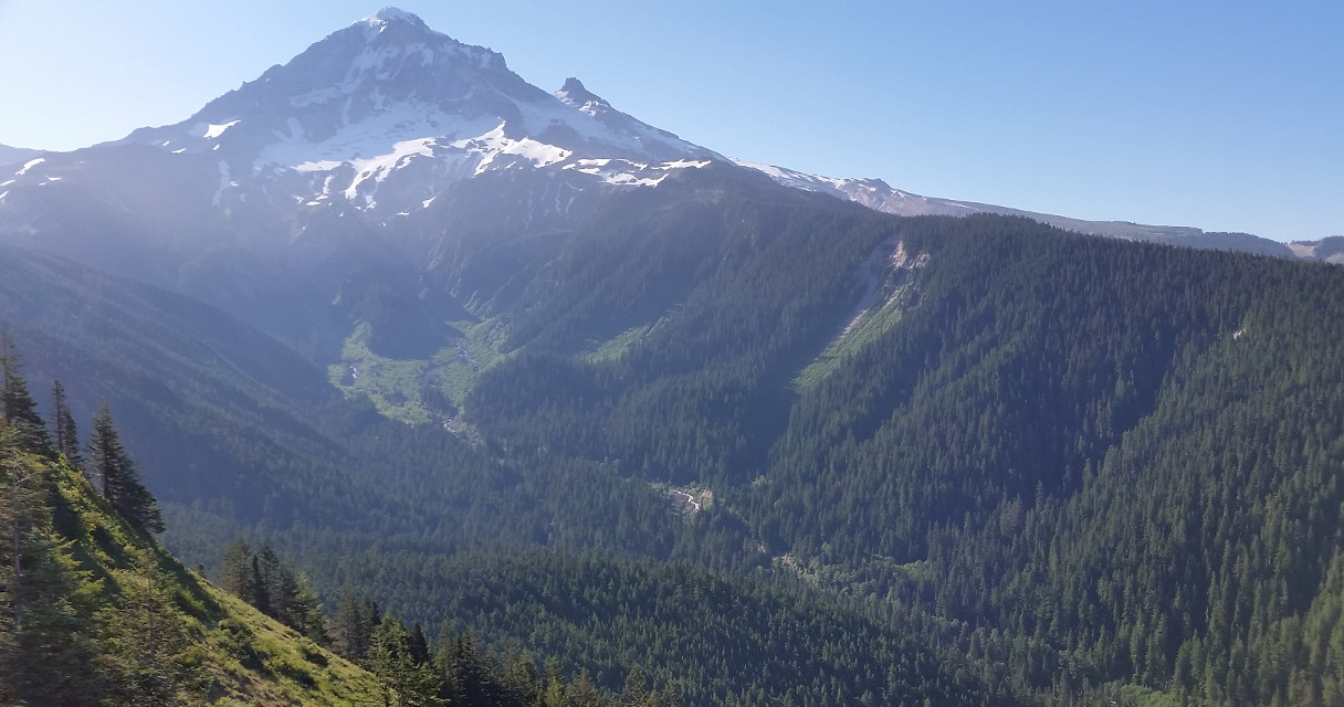
bluehead gilia. Here you can see Cone Peak, which I intended to scale. A lot of people taking photos here. Too pretty to go on.

Continue the trail to a narrower stretch, with no short of flowers. To the right, there's a boot track up to some rocky area. Follow the track into woods, very overgrown, eventually emerged out to the flowery slope to Cone Peak. Trail gets fainter and then disappeared altogether. Parts of this section is a bit of loose rocks, so take your time. What a great place to slow down. Every short steps up, the view gets better. Again, the bluehead gilia was nodding everywhere. 
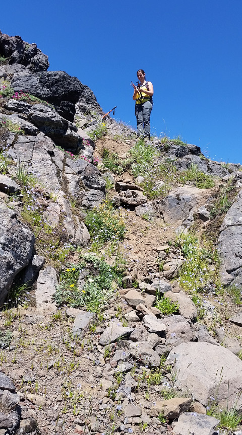
After cresting a rocky false summit, it's a slanting ridge to the end. There were 3 guys there, two are overweight. We had a long conversation with them, after I stupidly asked why Gary was carrying a hand gun. Interesting fellows. Mike is volunteering with the Eugene police department. He did most of the talking. Shawn added some details. They mentioned two places that I may want to checkout in the future: Devil's Staircase Falls (bushwhack + creek walk), Wolf Rock (scramble). You can see how steep some short sections are in this photo: Taryn was putting her poles. Hands work better.

Back on the main trail, we started to seeing other hikers again. Continued to Iron Mt. though some forest. Turn left up Iron Mt trail. About a mile switchback up to the new Iron Mt Lookout, opened in 2009. You can see the remnant of the old lookout a bit lower. Flowers on the way up. Interesting rock formation. 360° view. Hood is now obscured by Cone Peak. Here you can see highway-20 winding below. We chatted with this family at the lookout, here accompanying grandma for her birthday.

On the way down, met Shawn first, and then his two buddies. Back at the junction, turn left to continue our loop. Once we reached our car, we took water filter and headed down the gravel road (gated) looking for Hackleman Creek. Not much water, but it is running. Washed. We then picked up our pack and hiked down to the meadow to find a camping spot. We had the whole place to ourselves. I forgot to apply repellent, got quite a few bites while eating dinner. The sky didn't get dark until 10pm. Stars were quite lovely, but not much sunset or sunrise to see from here.

7/1, Sunday. Packed out. Saw a runner on the other side of the meadow while having breakfast. Drove about 8 miles to Crescent Mountain's trailhead. There's about 2/3 miles of wide gravel road, passable in all vehicles. No facilities at TH, but there're two pit toilets at a big parking lot (Lava Lake Snopark) just off highway-20. The locks here don't quite work (bad alignment).

I chose this trail for beargrass. There are a lot, but only few were blooming. I think my timing is good, maybe a small year here. The first 1.3 miles you slowly loose elevation till this footbridge over Maude Creek, the only water source on this trail. After some boring flat trail, it starts to gain elevation, slowly. 3 miles from TH, emerge from the forest to open slope. Tons of bracken fern and sage, covering the flowers. Quite a lot of scarlet gilia. View of Three Sisters behind. Then it goes into the woods again. Met a few people hiking out. At the next and only trail junction, turn right for the summit. Narrow, but flat and long. Closer view of the Cascades. At one end of the top, you can see Crescent Lake below. We had the summit to ourselves for a good 15 minutes before a large group of bikers arrived. Had a lazy lunch, wait till everyone was gone, and then treaded back. Saw a snake. Tons of butterflies. Will have to come back here on a good beargrass year.

Driving back is uneventful. A bit of traffic near Willsonville. I got dropped off at home. That's nice.

Early July is definitely a good time for flowers. Other hikes in the area that I'd like to check out are: Echo Basin (2 miles RT, need high clearance vehicle), maybe Browder Ridge - Heart Lake (11 miles RT), Coffin Mt (3 miles RT, for beargrass) and its neighbor Bachelor Mountain (3.8 miles RT).