10/30 Sunday 7:30pm. Portland Center Stage. The Oregon Trail is funny but simple tail of two Janes traveling Oregon Trail. “Now Jane” is playing the computer game in 1997 in highschool and then again in 10 years, now a failed and unmotivated adult; “Then Jane” is in a covered wagon in 1848, unwillingly being dragged along. Both have an upbeat sister. There could be more added, to both Janes, especially the modern Jane, whom the author has added many commentaries. A very innovative idea.
90 minutes. No intermission. Simple and efficient stage set. Good acting, and lighting.
Sunday, October 30, 2016
2016.10.30. OMS annual mushroom show
 10/30, Sunday afternoon (noon-5). Oregon Mycological Society organizes its annual fall mushroom show at World Forestry Center's Miller Hall. Even though the venu is also in Forest Park, it would take me 1:15 to walk, or 40 minutes by bus but leave 10 minutes later. I wasn't feeling so well, and it was raining, I took the bus. A line for the $5 admission. Probably a larger turnout than OMS had anticipated. Very crowded for the space.
3 talks at 1:15, 2:30 and 3:45. I missed 1/3 of the first talk about starting mushroom picking. 2nd talk is about the common fall mushrooms. Even though I'm not a true beginner, I enjoyed both talks. Didn't go to the last one, given by a nurse about poisonous mushroom.


 Mushrooms are staged on separate tables with green, red and white labels. They are a bit mixed up. On the peripheral are tables that sell membership, books, souvenirs, photos, mushroom growing kits. A tasting table was dishing out soups made with mushroom, which I tried two kinds. Both tasty, but they came in small quantities: half a cup. A table shows the 5 stages of commercial cultivation of mushroom. A table that have a few mushrooms which they encourage you to squeeze and smell.
A couple of hours well spent.
2016.10.30. Ivy basket
 10/30, Sunday. Drizzle all day long. 10am. Forest Park conservancy basket weaving workshop at Lower MacLeay Trailhead at 2960 NW Upshur. There, I was informed that yesterday, there was a city wide event to rid the invasive English Ivy. Here we had a pile of yesterday's bootie to work with.


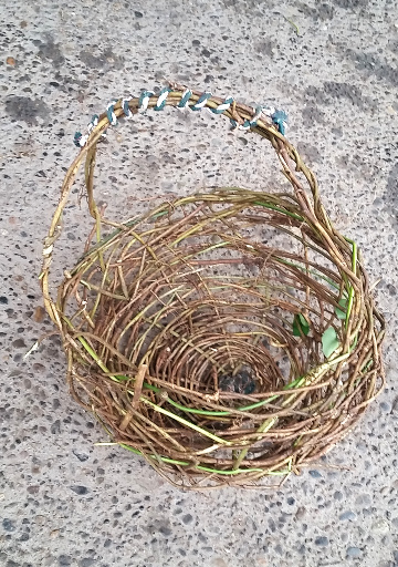 My progress is photographed here. I'm the last one who finished. I made the biggest, and probably the ugliest basket in all these workshops.
Advertised as family friendly. Only one teenager came with her mother, but the girl didn't do anything. All students were women. Taught by Lise Gervais, environmental educator. Only one guy, the organizer, working for the conservancy. Work gloves, and pruners, coffee and some snacks were provided. We worked in the picnic shelter. There is a bathroom next to it. From time to time, hikers walking by would stop and looked at us. Good publicity for the conservancy.
Saturday, October 29, 2016
2016.10.29. Hamilton - Hardy loop
10/29 Saturday. Rain - cloudy. 15 of us hiked up Hamilton Mt in steady but not heavy rain. Visited the aptly named Pool of Wind (a very short but must-do detour). Rodney Falls was in full swing.

 The next view area is above the rocky cliff overlooking the cloudy gorge. This is the best view of the hike. By the time we reached the summit, it was foggy. Not much of a loss. The summit of Hamilton is Anticlimactic. There isn't good sitting area even when it is clear, due to tall brushes blocking the views. You can see something only if you are standing.
  We opted for the baldy saddle a mile later for lunch break. Again, too cloudy to see anything. Here, I remembered good bloom in the right season.
 As previous 2 times, we took Don's cutoff. But instead of coming down (left) the Upper Hardy Ridge trail, we headed further out (right). Not much of a ridge. No view, except for the autumn leaves, which were covering the road-like trails. Then we walked down on Bridge Trail #76, joined East Hardy Trail. Then left on Equestrian Trail, right on Hardy Creek Trail.
  Eventually back on Hamilton Mt Trail, where we crossed the roaring Hardy Creek and Rodney Falls again. By now, sun has poked through the clouds.
There're many loop options. Check out the official trail map.
I picked 2 tiny chanterelles. Met quite a lot of hikers, especially in the afternoon. Back in town shortly after 3pm, in sunshine.
Sunday, October 23, 2016
2016.10.23 Indian Heaven: Thomas Lake to Lemei Rock
10/23, Sunday, drizzle. Too late (at least by 2 weeks) for the glorious fall colors in Indian Heaven. Most huckleberry leaves are gone. Still plenty berries left, which we feasted. But they are either too dry or too plump (diluted by the rain). Check out my previous blog when I backpacked in the area, 2 years ago.
 14 of us met at Gateway at 6:45, only started hiking at Thomas Lake TH shortly after 9am. Within 10 minutes, reached Thomas Lake. A good size camp site close to late, off the trail to your right. To the left is Dee Lake.
 Soon after, the trail goes up for a mile or so, before levels out again. We took a cutoff trail via Rock Lake to Junction Lake instead of going to Blue Lake. There, we took PCT north, then 33 NE, then 34 east to Lemei Rock. Came back on #179 to Junction Lake. Out to Thomas Lake via the same cutoff (not marked). For trail map, see this USFS website.
 #34 has a lot of huckleberries. Overall, very wet, water on trails, on leaves. Meadows still had nice yellow color, but no more red huckleberry leaves. Heard some gun shots. You might want to wear something colorful to avoid the guns. We didn't see anyone on the trail all day. Saw some vehicles on the forest road.
 Saw many colorful amanita mushrooms. Picked a few good ones. Not many as I expected. Chanterelles are for sale for only $11.99 at New Seasons Market. But I only found 2, and at the same spot.
We walked maybe 12 miles, 2000'?
Saturday, October 22, 2016
2016.10.22. Ralph Nader at the Rally To Get Big Money Out of Politics
 10/22, Saturday evening. Ralph Nader spoke at First Unitarian Church, as the last speaker of the rally for YES 26-184, to keep big money out of politics (in Oregon at least). The main measures are 1) the largest donation a single donor can make is $500; 2) an organization of small donors can contribute more, but at most $100 from each donor. The local speakers are Dan Meek (Oregon Progressive Party), Juan Carlos Ordóñez, Greg McKelvey (fiery speak, no substance, lots of jargon), Amanda Fritz. Most speakers are okay. Nader labels Trump as a buffoon, Clinton as a warmonger, and both are liars. There was his most recent book for sale and many others, which he'll sign at the end. I left before the Q&A session. Many groups set up tables at the entrance to get you sign something, or gave away brochures. You can take home a lawn sign of "Yes 26-184".
Update 10/23: I took a flyer at this event for Jill Stein at Roseland Theatre the next day. I did go almost on time (6pm), but it was rather chaotic. I asked a bunch of people when Stein would speak. Eventually I found a printout taped on a railing by one of the staircases, which stated that speakers start at 7:35. So I left, even though I would really like to hear Stein talk. It was too loud in the theatre by a 20 people band at the time.
2016.10.22. Columbia Slough and Smith Bybee Wetland
10/22, Saturday, partly sunny. After a class on Amazon Alexa, I went to check out the Smith and Bybee Wetland (not much water, muddy with dead looking grass) and Columbia Slough (quite a few tents and lots of trash). Not a pleasant walk. Not easily accessible using public transportation.
 I started from MAX Vanport station heading to "Vanport". No buses on weekend that goes near the area. A nice looking golf course, but its boundaries are all fenced off, including North Cottonwood Rd that is marked both accessible, and where Historic Vanport is, on Google Map. I didn't see any trace of the original Vanport, which either no longer exists or is on the golf course property.
 When walking on Columbia Slough, you have a good view of the golf course and Mt. St. Helens beyond. A few bridges, a water treatment area. That's to the north. To the south of the trail (more like a dike), you walk along the slough, you see quite a few tents and litter. Noise from a car race track.

 North Portland Rd and North Marine Drive (by Columbia River) are bordering the wetland to the east and north. Both with fast traffic and trash (I saw one pile of dead supermarket turkey -- all plucked). I'm walking on the official trail. There's a train terminal of some sort, lots of trains here.
  Smith and Bybee Lakes are swamp. I did see a few family walking here. Short paved trail, or mud to walk on. Didn't see many birds as I hoped.
 . Two entrances. The main one is to the north. It has two sheltered lookouts. Overall not worth coming, unless maybe in spring with more water and maybe a boat, or if you live in the neighborhood. A long walk from the train station (~1 hour).
I much prefer Alviso Slough and Coyote Slough in the south SF Bay, which I just visited last week. What a difference.
 I started from MAX Vanport station heading to "Vanport". No buses on weekend that goes near the area. A nice looking golf course, but its boundaries are all fenced off, including North Cottonwood Rd that is marked both accessible, and where Historic Vanport is, on Google Map. I didn't see any trace of the original Vanport, which either no longer exists or is on the golf course property.
 When walking on Columbia Slough, you have a good view of the golf course and Mt. St. Helens beyond. A few bridges, a water treatment area. That's to the north. To the south of the trail (more like a dike), you walk along the slough, you see quite a few tents and litter. Noise from a car race track.
 North Portland Rd and North Marine Drive (by Columbia River) are bordering the wetland to the east and north. Both with fast traffic and trash (I saw one pile of dead supermarket turkey -- all plucked). I'm walking on the official trail. There's a train terminal of some sort, lots of trains here.
  Smith and Bybee Lakes are swamp. I did see a few family walking here. Short paved trail, or mud to walk on. Didn't see many birds as I hoped.
 . Two entrances. The main one is to the north. It has two sheltered lookouts. Overall not worth coming, unless maybe in spring with more water and maybe a boat, or if you live in the neighborhood. A long walk from the train station (~1 hour).
I much prefer Alviso Slough and Coyote Slough in the south SF Bay, which I just visited last week. What a difference.
Friday, October 21, 2016
2016.10.21. Emma Donoghue at Powell's
 10/21, Friday evening. Emma Donoghue speaks at Powell's City of Books for her new fiction The Wonder, about an English nurse brought to a small Irish village to observe what appears to be a miracle – a girl said to have survived without food for months – soon finds herself fighting to save the child's life. In Q&A, she talked about screen play adaptation, Oscar award ceremony, the little impact of Irish Catholic heritage, her attachment to both Island and Canada, her writing. I enjoyed her talk very much.
Thursday, October 20, 2016
2016.10.18-19. Alviso Marsh in southern San Francisco Bay
 10/18-19 Tuesday and Wednesday mornings. I went for a walk/jog at the salt marshes of Alviso in south San Francisco Bay, part of Don Edwards San Francisco Bay National Wildlife Refuge. An official trail map can be found here. This is where my route is devised (two trips). I highlighted where I went using green overlay color.
  Highly recommended for dawn and dusk, not just for better color, and probably more active birds, but also because there's no shade in the whole area: marsh and mud. You can bring a canoe here. Or just walk. Not crowded. I saw one person each day. I would avoid this in the summer months: there might be sewage smell, and probably mosquitos.
 I was in the vicinity for work. I headed out at ~7:30am, nice crispy weather. Should leave earlier. I came back at 9:00 the first day, and 9:45 the 2nd. By 8:30, it was already getting too sunny. I mostly walked, a little jogging. The mud caked onto my soles. Hard to run where the mud flies off your shoes from time to time. Saw many birds. Most noticeably egrets. They are big and white, and standing right in Alviso Slough where the train track and road cross it: very close to my hotel. Groups of pelicans further out. They fly overhead from sometimes. Many black necked stilts, whose neck isn't all black, avocet. Lots of little birds and gulls. First day, I walked mainly along Alviso Slough. Whenever I walk by bushes, I could hear rustling sound. Saw a chickadee size black bird with white belly. Not sure what it is.
 The 2nd day, I went to the NWR education center (further away). It was not open yet when I arrived. Nice boardwalk there. Quite a few benches here and there.
 There's a shelter with picnic tables. More land area and mud. Saw two rabbits. Lots of pelicans. The green marsh area on the map is half water. Those salt ponds are really ponds, separated by dikes of mud. The "Trail Connection" is real. That's the only place you can go from one side of the train track to the other, because instead of one dike, there're three separated by ditch of water. On the dike, each step is triggering hundreds of little flies to jump up for a few inches, and settle down again. Feels like walking in low gray clouds. Strange.
A good workout, nice scenery.
Tuesday, October 18, 2016
2016.10.18. Cruise in the San Francisco Bay
 10/18, Tuesday. Sunny with a few clouds. Met at Jack London Square of Oakland. The waterfront looks quite nice. Just a block inland is wholesale and warehouse, so not very pretty any more. For a team event, a dozen of us were here to board a sailboat, cruising along San Francisco Bay.
 The most interesting aspect is seeing the container ship and the cranes up close. They are huge. We also some some trash piles (including flattened cars) waiting to be shipped (to where?).
 As far as sightseeing goes, we were not pointed to anything. Half of the passengers are local, so I knew when we went under Bay Bridge, where is SFO downtown, Golden Gate Bridge, and Alcatraz Island (quite a few ferries going there).
 The captain was mostly seen behind the wheel. Two crew members unfurled the sails and later packed them, as well as server us drinks and food which we brought along (so less people were walking around and the boat would suffer less impact). When asked, one guy told us about the wind condition (always predictable in summer when central valley heats up in mid day), and buoy colors (keep the red on on your right side when going upstream). There's a toilet, which you pump for the content to go down. Probably goes directly to the ocean (yuk!).
Sunday, October 09, 2016
2016.10.9. Broken Top Crater(s)
 10/9, Sunday. Woke up to blue sky with feathery clouds. A good sign.
 Todd Lake picnic site is less than a 10 minute walk from the parking area where the above photo was taken. That's on a NF370 off (N) Cascade Lakes Scenic Byway. The gravel road continues (deteriorates) after a sign of "Road NOT Maintained". Once reached the lake, good view of Broken Top at the picnic and camping area. There's a sign saying: Todd Lake was named for central Oregon pioneer John Y. Todd. In 1860 he built Sherars Bridge. The first structure to span the Deschutes River. Todd Lake is nestled in an ancient Dacite Volcano that was last scoured by glaciers 18000 years ago. The receding glaciers left behind a rock basin holding Todd Lake which covers 33 acres to a depth of 60 feet. The lake's outlet disappears into permeable volcanic terrain about 2 miles southwest of here. Introduced eastern brook trout now support a popular sport fishery in this once fishless lake. The north half of the lake has good view of Bachelor.
 I started at 8:00 to Todd Lake (6150'). There's a trail around the lake, which is different from Todd Trail. Had to scale the slope to catch Todd Trail. Soon I hit snow. It gained a bit of elevation, then more of less flat if not going down, until reaching Broken Top trail. Turn east (right). Since it's my first time, not sure where to turn to go to No-name Lake. Judging from the topo map, I picked a route north follow some footprints on the snow. It's all quite flat here, and a lot of snow. A few minutes later, I saw a guy (with no pack) coming from east side. I said to him: "I hope we are on the right trail". It turns out that this is his first time, in fact, he just moved here a few months ago and wanted to check out the mountain in the morning that he could see from his home very day. We continued together, as there were still foot prints to follow. 10 minutes later, saw two guys in serious outfit coming our way. One said he was here a couple of times before, and I was on the wrong side of the hill for No-name Lake. I felt tired all of a sudden. Decided to take a snack break, and consider my options.
  Felt better after half a sandwich. Since it was still early, I continued forward. More or less followed the main creek up. The basin was now snow covered braided with rocks and melting creek. Once get to the water outlet, (by then, the "trail" is loose and steep), you turn right up the slope to its top to stare at Crook Glacier and the small basin. No lake here, or maybe in summer, there would be a pond. I got here shortly before noon. Very very windy! Hard to breathe at times. Coming down a loose slope is always not pleasant. Luckily, it isn't too long.
 Back down the basin. Headed to a low point over a treed ridge. Once on the other side, I could see people. Soon, I myself is on the trail. Even though it isn't marked on my topo map, the trail is as good as any maintained trail in the area. A lot of people on this trail too, ponding on the snow, so it's hard to get lost.
  As soon as you see the lake (1:30pm for me), you'd go Uhh and Ahh. The color is a beautiful green, appears sometimes bluish depending on the angle you look at the water. The lake is almost heart shape. The basin was now entirely covered with snow.
  Walk to your right along the edge, slowly gaining elevation to a ridge. From there, you can see all 3 Sisters up front, two frozen tarns below, and maybe Three Finger Jack and Mt Washington further north. The jagged Broken Top spires are red and brown. Very colorful. I walked out of this gorgeous lake basin via a different access. Very windy at places.
 My feet were again wet, and I was a bit tired and lazy. I followed the trail out, all the way to Broken Top Crater trailhead (around 7150', snow at parking lot). It's easy and straight forward, took me 1.5 hours. There were still people hiking in. I was hoping for a ride, so I waited at the parking lot. Being a woman hiking alone is easy to hitch a ride. I asked the first two groups hiked out, and was accepted by both. I rode in an SUV with 4 day-hikers and a dog. The road is very bumpy. It took a good 30 minutes for the 4-5 miles. If I hiked out as I came in, it would be 1.5 extra hours. Here's the estimated route I hiked this weekend. About 12 miles each day, making the 8 hour drive worthwhile.
After a short stop in Detroit for gas and a bathroom break at the rest area, I hit rain, pouring rain all the way home. Traffic was moving slower than usual. Got home at 8:40. Still have to return the car. MAX on Sunday evenings are not very frequent, I had to wait for 30 minutes.
Saturday, October 08, 2016
2016.10.8. South Sister Climb - standard south route
My second attempt, and turned around again due to clouds.
10/8, Saturday. Thick clouds in Portland. Weather forecast for South Sister area is partly sunny for the weekend. However windy at higher elevations. I rented a car and drove south. Rental agency doesn't open until 9. So a late start. It's a 4 hour drive including a toilet break.
 Parked at Devils Lake official trailhead. It's on the wrong side of the highway. Unless you camp here, it's easier just park by the road, where the trail picks up on the right (north) side of the highway. When I filled a wilderness permit, it was already 1:30pm. So I hastened my pace. Less than 30 minutes into the hike, I hit snow. The trail is easily visible by the bounding of passing boots. It was wet, slushy, and slower than I needed to summit, which is 6 miles and 4900' up. The sun sets at ~6:30pm this time of the year. 1 hour from TH, you break out of the trees. Soon a trail junction. The trail westwards is signed to Wickiup Plain.
  A few minutes later, another trail junction. The one NE signed to Moraine Lake. It's quite pretty here, but wet. You can see Bachelor, Broken Top, Moraine Lake below, and Sparks Lake far south. I met a group of 3, of which I know 2. Chatted for a bit. They turned back at around 8000'. We couldn't see the summit at the time. As clouds moved in and out, I continued. The trail isn't steep. More rocks and more exposed as you go higher, and the wind got stronger.
 Around 5pm, I got to Lewis Glacier. Very windy. I had to cover my mouth or turn my back in order to breath.
  I continued along the right to the left of the pond for another 20 minutes, and turned back. I was at maybe 9200' according to the GPS location. As you could see the photo on the left, visibility was getting quite low. The summit is at 10358', and maybe 1/2 mile away.
 Quite colorful western sky under thick clouds. Saw a camper with fire in the plateau above Moraine Lake (not sure if open fire is allowed, but with so much snow, it poses no risk). The night set quickly after. By the time I got back into the woods, it was quite dark. With the half moon sometimes out of the clouds, I could see a bit. However, at some point I lost the trail. My headlamp was getting quite dim. It took me quite some effort to stumble out of the woods and on to the road, aided by the GPS map on my phone. Even with gaiter and waterproof boots, my socks still got a bit wet.
I drove to Todd Lake parking area. No energy to check out the campground, even though I knew it was a short walk, because I wasn't familiar with this location. Slept in the car.
10/8, Saturday. Thick clouds in Portland. Weather forecast for South Sister area is partly sunny for the weekend. However windy at higher elevations. I rented a car and drove south. Rental agency doesn't open until 9. So a late start. It's a 4 hour drive including a toilet break.
 Parked at Devils Lake official trailhead. It's on the wrong side of the highway. Unless you camp here, it's easier just park by the road, where the trail picks up on the right (north) side of the highway. When I filled a wilderness permit, it was already 1:30pm. So I hastened my pace. Less than 30 minutes into the hike, I hit snow. The trail is easily visible by the bounding of passing boots. It was wet, slushy, and slower than I needed to summit, which is 6 miles and 4900' up. The sun sets at ~6:30pm this time of the year. 1 hour from TH, you break out of the trees. Soon a trail junction. The trail westwards is signed to Wickiup Plain.
  A few minutes later, another trail junction. The one NE signed to Moraine Lake. It's quite pretty here, but wet. You can see Bachelor, Broken Top, Moraine Lake below, and Sparks Lake far south. I met a group of 3, of which I know 2. Chatted for a bit. They turned back at around 8000'. We couldn't see the summit at the time. As clouds moved in and out, I continued. The trail isn't steep. More rocks and more exposed as you go higher, and the wind got stronger.
  Around 5pm, I got to Lewis Glacier. Very windy. I had to cover my mouth or turn my back in order to breath.
  I continued along the right to the left of the pond for another 20 minutes, and turned back. I was at maybe 9200' according to the GPS location. As you could see the photo on the left, visibility was getting quite low. The summit is at 10358', and maybe 1/2 mile away.
 Quite colorful western sky under thick clouds. Saw a camper with fire in the plateau above Moraine Lake (not sure if open fire is allowed, but with so much snow, it poses no risk). The night set quickly after. By the time I got back into the woods, it was quite dark. With the half moon sometimes out of the clouds, I could see a bit. However, at some point I lost the trail. My headlamp was getting quite dim. It took me quite some effort to stumble out of the woods and on to the road, aided by the GPS map on my phone. Even with gaiter and waterproof boots, my socks still got a bit wet.
I drove to Todd Lake parking area. No energy to check out the campground, even though I knew it was a short walk, because I wasn't familiar with this location. Slept in the car.
Subscribe to:
Posts (Atom)