12/30 Tuesday. We left home after lunch. After filling up gas, we headed towards southern Oregon coast. Gas price goes higher more south we go. Umpqua River is quite scenic, and there're two spots we saw elk from the car.
  By the time we arrived at Umpqua River Lighthouse in Winchester Bay, the sun has just set. Still had an evening glow, accompanied by dirt bike noise on the dunes below. This is a working lighthouse. Of course all lighthouses, working or not are closed to public in winter months. Going through North Bend and Coos Bay at night (not 6pm yet) is picturesque: myriads of light reflecting on many bodies of water.
 12/31 Wednesday. Cloudy in the morning, then sunny. We started at Shore Acres state park, which we both visited ~10 years ago with a friend who's now deceased. It brought fond memories of old time. The park was now dressed in Christmas lights (of course not turned on during the day) and glaring posters of the donors of either the lights or Christmas trees. Saw a couple of rhododendron flowers, confused by the unusual warm December. Short stops at Simpson Reef overlook (lots of noisy seals) and Cape Arago, both with beautiful rocky ocean view, before we went back on Hwy 101, continuing south.
 Before entering Bandon, a short stop at Bandon Marsh national wildlife refuge view point. Didn't see any bird except the one who flew away when we parked, maybe a peregrine falcon.
  Forgot to bring a pair of binoculars. The marsh was more or less dry at the time. We visited the site of Coquille River Lighthouse on the south jetty of the Coquille River mouth all the way in Bullard Beach state park. Long stretch of sandy beach to the north. Open space. Quite windy.
 Lunch at Coquille Point in the city of Bandon, stunningly beautiful, right by an ugly motel. Short trail to walk around, with sign post about the geology and animals. Possible to descend to the beach with many sea stacks.
  Two volunteers were stationed at a picnic table to educate about whale migration. You can borrow their binoculars. The lady told me that she saw 19 sprouts since 10am today. I saw nothing. The white caps of the wave under the sun are too bright. A short stop a bit south at Face Rock viewpoint. Many cranberry bogs south of Bandon. Tour possible in fall, and a big festival.
Cape Blanco state park has another lighthouse. This is the west most point of Oregon. Super windy here.  On the way, there's a restored old farm house of Hughes (1898). Quite elaborate for a farming family.
 We hiked a short trail in Port Orford Heads state park. Very nice. Saw only one elderly couple, many seals. Battle Rock city park is a must stop. Lots of rocks, flat beach right by Hwy 101. Some succulent plant is flowering, big and red.
Drove by Humbug state park, quite scenic, with roadside pullouts. We stopped at the trailhead (pdf). But dad wouldn't walk over a shallow creek. So we headed directly to Gold Beach, where I managed to check into a hotel right before sunset. We sat at our humble balcony, opened a bottle of white wine, and drink to the last sunset of 2014. Yes, even though this small town has no planned event, it was quite noisy in the evening.
 1/1 Thursday. Sunny. I started today with a jog on the beach at sunrise. Not much color, but it was nice and quiet. Today is filled with jaw dropping beauty. Cape Sebastian state park (day use only) south parking for overview of coast. Meyers Beach is full of sea stacks like whales tails.
We walked to the river at Pistol Creek viewpoint, and over the sand dune for the ocean view. Saw at least 5 otters bobbing up and down in the river. At Arch Rock point, we met 2 women making sketches. Brief stop at Natural Bridge view point. Thomas Creek bridge is the highest in Oregon. Trail is at the south end, with some root exposure, and minor slope. At the end of the lower trail, it seems possible to walk down to the creek bed, but it's too steep, and I gave up.
 Samuel Boardman State Senic Corridor (map) near Bookings is indeed scenic. Free access, no camping facility. Oregon Coastal Trail passes the corridor. I'd like to do some one way hike here. We had lunch at one of the picnic tables overlooking Whaleshead beach. Absolutely gorgeous. Cape Ferrelo has an overlook high above water, excellence place to watch whales (December and March). We saw quite a few sprouts, some quite close to shore. Lone Ranch is a bit lower, equally good for whale watching.
  Rainbow Rock beach, again, breathtakingly beautiful, has a row of picnic tables overlooking the beach and sea stacks. Last rocky seascape north of Brookings is Harris Beach, equally stunning. Nice bridge over Chetco River and lots of boats. Just north of the state line, Crissey Field state park has a very modern visitor center (closed on new year's day, except for the bathroom ). Beach access.

California looks very pastural. Highway 101 was diverted to a checking station. The lady only asked where we drove from. Detoured to 197 (along scenic Smith River) and 199 (in
Jedediah Smith Redwood state park), an excellent introduction to towering redwood. All paved, curvy narrow road under giant trees. We stopped at the Redwood park visitor center (closed) in Crescent City and picked up a park newsletter with
map. Brief stop next to Battery Point lighthouse. We walked the short
Stout Grove loop trail after 4 miles of dirt Howland Hill Rd. An interesting drive on many potholes among the giants. Checked into a motel on Crescent Beach, with an oceanfront balcony.
1/2 Friday. We drove through the Tour Thru Tree in Klamath. No one was at the gate. Luckily I had a $5 bill, so shoveled it into the collection box. Then a driveway length later, you see a tree with a hole in someone's backyard. Being in winter, not many visitors. The truck in front of us was just taking photos, but they didn't drive it through. The hole was quite narrow. I slowly edged my rental car through, once with dad inside the car, once for him to take photos. The wall of "tunnel" inside of the tree is made very smooth.

 We drove to the Klamath River overlook first on the north shore of the river mouth, high above a bluff. Very scenic drive. Picnic table. Then, took the loop of Alder Camp Rd - Coastal Drive - Klamath Beach Rd just south of Klamath River. Visited the radio stations disguised as farm house (of course closed) and Douglas Memorial Bridge (1926-1964). Quite scenic. Newton Drury Scenic Parkway was closed (not sure why, not mentioned in the park newsletter). A bit south is the aptly named Elk Meadow. Sure it was, a herd of elk. It's possible to park further south and walk on a bridge for a better view of the herd (Trillium Falls trailhead is here).
 Tall Tree Grove, lots of tall rhododendron. Free 50 permits per day (request at Thomas H. Kuchel Visitor Center 3 miles west of Orick).
  Locked gate with a paddle lock (the letters are so tiny, that I had trouble align the 4 numbers). 20 minutes on 6.5 mile gravel road. I agree with the author of that link, the trees here are not discernibly bigger or taller, and the grove is small. According to National Park Service, in 1963, the tallest tree was found here at 368'. Since then, taller trees were measured else where, but locations not disclosed. Same here, nowhere we could find which one is this tree.
  I like the river by the grove. The challenge of getting here also adds to its charm.
  On the way out, I stopped at Lady Bird Johnson Grove, and ran the 1 mile loop, while dad waited at the parking lot (with a privy). Lots of kids on this trail: easy access, leveled trail. In August 1969, President Richard Nixon dedicated the grove to the first day of Lyndon Johnson.
 On the way down on Hwy 101, we saw a big herd of elk right by the highway, causing some traffic.
 It's very senic going through Humboldt Lagoons state park. Freshwater Lagoon, Stone Lagoon, and Big Lagoon. All three are pretty big. Now a bit low on water. Made it to Palmer's Point (185') in Patrick's Point state park just before sunset. Then, it was a long windy drive along Hwy 299 to Reddings. I probably should allow some time exploring this stretch of the road.
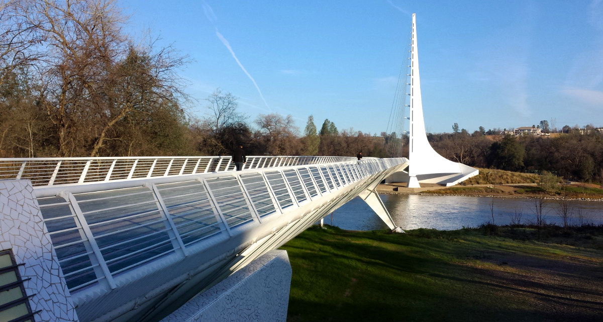
 1/3 Saturday. Sundial Bridge is an elegant pedestrian bridge over Sacremento River in a lovely park complex right by downtown Redding,
  free of charge and parking. On this Saturday morning, we saw a few joggers. The glass on the bridge was still icy to walk on. Despite the claim, I failed to correlate its shadow and time.
 Shasta Dam (2nd largest in US in terms of concrete volume after Grand Coulee Dam). They offer daily tours. We watched a bit of the movie, didn't want to wait for an hour for the next tour. The surrounding is beautiful.
Castle Crags state park. We drove to Vista Point. Had to wait for a group of kids practising skateboard on this very road. They were well organized, setting up stop point to hold motor traffic. At the top, there's 0.25 mile wheelchair-accessible dirt walk to flat top with picnic tables and 2 telescopes. A fine view of the Crags to the south, Mt. Shasta to the east (by passing some trees), and another mountain range to the west (blocking by more trees). Fee station $8, without anyone at the gate. In order to pay, I had to buy something at the gas station by the hwy exit.
Took Shasta central exit all the way to bunny flat at 6950', the highest one can drive to on Mt Shasta in winter. Lots of people playing with snow. I brought along a lawn chair, snowshoes and microspikes. Dad tried them all. Warm enough, no wind, great view. Perfect for lunch.
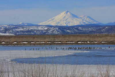 Hwy 97 towards Klamath Falls is quite scenic: open space, with view of Shasta on your right, and later Mt Mcloughlin's perfect triangle peak on the left. We made a brief stop at Veteran Sculpture Garden, and by lower Klamath Lake on Hwy 161. So much water. I need to come back to this area with binoculars in spring to see the migrating birds. Stayed at a Winema Lodge overlooking Tule Lake NWR. The establishment belongs to a hunter's club, so you'll meet old gentlemen dozing off in the cozy living room in front of the fireplace. I, too, dozed off on one of the many lazy-boys. Our room, however, is in a one level roadhouse on its side, cold and spartan, paint peeling off. Sad to see. The lady who manages the lodge is very nice, but she knows nothing about birds, and has never been to Lava Bed national park, which is heavily advertised on their website.
 1/4 Sunday, cloudy. Lava Bed National Monument. We visited two easy caves: Paradise (waste of time), and Skull Cave (huge, good for the ice floor, but closed). We did a hike at Captain Jack's stronghold for a sense of the Modoc War. The craggy barren land is certainly a good hideout, with all the caves. After a stop at Petroglyph Point. Disappointing. Saw only one good drawing, and many bird nests.
 Headed home. Driving along Upper Klamath Lake along Hwy 97 is very scenic. However, there's no viewpoint stops. The traffic is heavy and fast to pullover. We found the small Henzel Park next Agency Lake for dad to take pictures. The locals were skating on the lake. Our last tourist stop is Lowell Covered Bridge right on my way to I5. It was lifted when the river was flooded to make Dexter Reservoir and place here next to the main concrete bridge, so completely useless. Yes, it's closed too. Dad wanted to go shopping, so we stopped by Woodburn outlet mall before they close at 7pm (on Sundays).
 We parked at the hatchery. Follow Eagle Creek trail 440 for 5.3 miles to the junction with the Eagle Benson trail 434 at about 1,000' (easy to miss). This 5.3 miles is a delight: narrow gorge, green moss, many waterfalls.
  Just at Wy'east Fall, we went straight up (left) on Eagle Benson trail: 3000' in 3 miles to Camp Smokey on the PCT. On the way, passed some burnt trees, and many blown down for you to duck under or stride across. For awhile it was on a ridge, with occasional views.
  Before dipping lower to Camp Smokey, we stopped at a high point with some sun and view. It's small, hard to accommodate all 17 of us. I filled some water at a creek just before reaching the camp. It had no view, and no sun, half of the people got cold. Right after the last 2 caught up, we continued.
  Turn north here and follow the PCT for .4 mile to a junction with the Benson Way trail 405B, to the left. This is, again, easy to miss. Follow Benson Way trail on the west side of the plateau for 1.8 miles to Hunters Camp and the junction with the Ruckel Creek trail 405. 4.5 miles and ~3600' down on Ruckel Creek trail to its start at the Gorge trail 400 (by the Old Historical Hwy).
 The top 3 miles are boring, completely in trees. Occasionally a few big trees. On the way, we saw some Indian pits, and soon after, half of us made a stop at a sunny slope with a view to the gorge. The last bit is a short walk on the road, and checking out the salmon hatchlings in the pont.


.jpg)