 10/17 Friday, cloudy. I arrived at Phoenix Sky Harbor airport ~11pm the previous night, was picked up at 2:30am by the organizer. Got to the meeting spot at 2:45 as planned. 5 people were already there. As always with a large group (13 total), some were late, we didn't depart until 3:20am. In "my" car, are the old folks, other than a lady of my age, 3 others are older if not a decade older. The other 2 cars held kids in their 20s. A bathroom break, a long (6:30-7:30, not in the plan) breakfast at Seligman (the last town with regular services). Finally arrived at the trailhead (end of tribal road18, all paved), Hualapai Hilltop (elevation 5200') at 9am. Big parking lot next to a stock area where mules and their loads are gathered. Lots of cars already, lining both sides of the road. Long line in front of the toilet. Photos left and right. It's the first backpack trip for some of us. We started hiking down at 9:40. I was pretty tired by then, sitting in the middle seat for 5 hours. Good that we were slow.
 Trail is easy, but long (10 mile). Sandy, lots of small rocks. Once a while, step aside for the packing animals. After the initial elevation drop to Hualapai Canyon, it's mostly flat, like walking in a river bed, until reaching the junction of Havasu Canyon (mile 6, an almost dried up spring shortly before that). Now more trees and sandy like on a beach, in a narrow canyon where Havasu Creek runs with a light blue-ish hue. Water is pretty clear. At mile 8 is Supai village. Beautiful setting. Wide. Lots of little yellow daisy like flower and many giant morning glory like flower by the road with dust leaves. I don't see much agriculture here. I didn't see many local people, certainly no one walked. Plenty horses and mules, dogs too. Contrary to what I read online, people seem pretty friendly. Some animals are visibly starving, but that's not the norm. At the tourist office, all visitors have to register. We have a group reservation of up to 15 people. Each one of us paid $81.40 ($35 entrance + $5 environment fee + $17/night + 10% tax) for a red ribbon (dates, name of the person who reserved, party size) on our wrists. They take credit cards, cash if not big bills. We checked in at ~1:20 pm. There's a cafe next door (opens 8-6, last order at 5:45, no backpack inside, flush toilet). If you are in town at non business hours, there's a water faucet, 2 toilets next to a small grocery store, or you can look for a proper toilet in the modern looking elementary school.

 After the village, the canyon narrow again. Pretty soon, the little creek turns to the first waterfall, or rather the lower Navajo Falls. Walk to the big flat rock right next to the lip of the falling water, perfect for lunch. Continue a bit further, you'll get the view of the upper falls (don't walk down, no view).
  The sandy route continues, until you hear thunder. There, is the most stunning waterfall plunging to a blue pool, cascading down some terraces. I changed to swimsuit and dived in. Chilly. But once you are in the water, it's not bad. It took considerable time to change clothes without any cover (I used a big towel). Soon after is the mile long camping area, where you can pitch a tent anywhere, even next to the creek (a big nono where I'm from). Spring water out of a faucet for drinking, a few compost toilet houses with plenty toilet paper, wood chips for odor (yes, it's clean and doesn't smell bad at all), a night light.
 However so many groups, no place for food waste and washing water, once awhile you get a whiff of unpleasant smell (food mixed with urine). At the entrance of the camping area, there's the depot for luggage (hauled in and out by mules) and two big garbage cans. Our next door is an organized group led by a studious young lady. She brought huge coolers and so much food, that she gave us pasta for the first night, and veggie burrito for the second! After setting up the tents, most of us walked to the end of the camping area, and down to Mooney Falls. You need both hands to go down. Was fun.
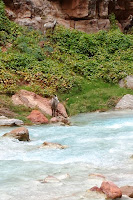
10/18 Saturday, partly sunny.  4 of us from the same car decided to head to Colorado River. We left at about 6:30am. Already enough light. Still we took flashlight, as we didn't know when we'd be able to make it back. Even though two of us had been here before, none walked pastes Beaver Falls, 2-3 miles down. We were told that we had to ford the creek 8 times, and water can be as high as our waist. After Mooney Falls, it was mostly flat. At the first couple of crossings, we changed shoes. Soon, putting on/off the boots became too much trouble. Wearing a pair of socks in water shoes is a good idea. Our progress is slow: taking too many photos. The creek is very pretty, as well as where it is: the canyon with straight walls. Some parts are wide, overgrown with blackberry type of bushes.
  At mile 3?, Beaver Falls is the prettiest of the endless water terraces: bigger and higher. We walked down to the water, and spent at least half an hour there.
 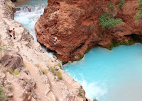 A bit further down is a deep blue pool, where 3 young men were diving. It took them awhile just to climb back on: a thick rope? chain? was permanently fastened to the cliff to aid them up.
 Similar scenery continues. Less frequent creek crossing. All at most knee deep. We saw a family of sheep (we were told later they are not goats). I didn't see the only male with big horns, captured by Neil's camera.
  The scenery turns to more dramatic as we were close to Colorado Rive: the wall deepens, shinier. The sleepy creek at the camping area is now a rushing force. The three boys are returning from the river. They are fast. We met a group led by 3 guides, some of them were in their 60s, coming in from the river.
 There's a visible line between the clear blue Havasu Creek, and the brown silty Colorado River. 3 rafts were moored there, as well as 2 boats. Lunch, nap, enough flat rock to rest and admire the view.
On the way back, we met the same group and no one else, not the sheep either. Less photos, so faster. We left at 1:10, and arrived at Mooney Falls at 4pm. I went in fully clothed. Good to wash away all the sand, mud and sweat. Yes, a bit chilly, but only when you go in. The force of the falls is too great to get under the falls. The kids of our group applauded as we came back one by one all wet. A heated discussion as whether to walk up or take the helicopter tomorrow (first come first server, 10-2pm, locals have priority). We all decided to get up at 6am.
Less cloudy. Not a bad starry sky, only a long strip, cut on both sides by the canyon walls.
10/19, Sunday, sunny. When we were in the village (~8am), already about a dozen lined up outside of the helicopter pad. Not a lot of shade once you are out of the narrow canyon (the last ~4 miles). Good that I filled up my water bottles, was able to give Debbie some. She only brought 1 litre of water for the 10 mile hike! Another boy later complained that he ran out of water. But we didn't see him (in the last group of 3) until 2pm in Seligman, where we waited in the Lilo restaurant. There's drink for sale at the parking lot. All 13 of us walked up. The possibility of walking up in the afternoon sun is enough of the deterrence of waiting for a helicopter ride.
 Driving back was uneventful, we all fell asleep at some time. As we drove closer to Phoenix, the clouds got larger and darker. I saw Humphrey Peak, the tallest mountain in Arizona. Still a bit snow on the top. We stopped at Sunset Point rest area (I-17 exit 252) in time for sunset shots. Perfect dark red clouds, lightening occasionally, no rain yet. By the time we were in Phoenix, it was pouring. I was dropped off at the airport around 7:30. My flight was at 10:50pm - the very last flight. The security here is more strict, my peanut butter jar was deemed dangerous. I arrived at PDX ~1:30am Monday. Still a long way home, and I have an 8am meeting every Monday: work sucks!
 10/25, cloudy - snowy - rainy. 8 of us arrived at the trailhead with some blue sky above us. Chilly. People are slow putting their boots, gaitors on, 30 minutes! By the time we headed out, dark clouds have moved in. Our hike leader Garth is very fast, so are Sam and Natalie (if not faster). I'm slightly better than the other 4. We arrived at the stone shelter of Cooper Spur in clouds. Fresh snow on ground. The shelter is stocked with some wood, a lantern, and enough room for 2-3 to lie down.
  Wind was hollowing, making flip sound of the tarp roof. We continued on Timberline Trail. As Shelly is visibly uncomfortable on the snow, even though someone put microspikes on her, as soon as there's a slope, we decided to turn back. Only 3 miles! Snow was getting a bit deep at parts. Gusty wind isn't helping. We came down Tilly Jane trail, snow free, and visited the big Tilly Jane cabin. A group came in with a key. You can reserve it 3 days in advance. First snow for me this year.


