Saturday, May 31, 2014

2014.5.31. Saddle Mountain

5/31. Saddle Mountain in the coastal range. 1.5 hour west on Hwy 26 from Portland. 2.5 miles one way, 1600' gain. 15 of us hiked this flower heaven, 1 week before my trip here last year. Glad that Mary V. was in the group. Always learn and relearn something from her. Learned a new flower: copper bell. Among others, but not limiting to, are: chocolate lily, Oregon iris, Goat's beard, Baneberry, Smith fairy bell and hooker fairy bell, Larkspur, yellow Monkey, red Columbine, red paintbrush, rosy plectritis, mallow, fringecup, flox. Most abundant now is field chickweed, and buttercup.
Too cloudy to see the promised view. Sunny in Portland :(.

Saddle Mountain Trailhead (Latitude: 45.962883, Longitude: -123.689990): Hwy 26 west of Portland for ~60 miles, turn north just before milepost 10 onto Saddle Mountain Road. Go 7 miles on this paved, but bumpy road.

Wednesday, May 28, 2014

2014.5.22-28 Grand Canyon + Bryce + Zion national parks

5/21 Wednesday, landed at Las Vegas airport ~9:30pm. Picked up a case of water and beer, checked into hotel.

5/22, depart at 8am. Checked into hotel in Grand Canyon at 1:30pm. 2pm, I took a trans-canyon bus to North Rim Lodge, and arrived shortly before 7pm. Not much sunset to speak of: too smokey.

5/23, day hike from North Rim to South Rim, with a short detour to Ribbon Falls.

5/24 Saturday, drove east out of the park, stopping at Grand View, Moran Point, Tusayan Ruin, Lipan Point, Navajo Point, and Desert View. All worth stopping with jaw-dropping views, other than the ruin. From the last couple of viewpoints, you can see a little of Colorado River. 
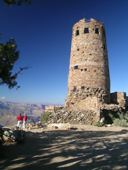
I really like the watchtower at Desert View by Mary Colter. Circular balconies inside with windows for the view outside. Plastered wall with native themed decoration, delightful.

After a stop at the Little Colorado River Canyon (a Navajo tribal park - not worth a stop after Grand Canyon - no water), we headed to Page. 89 is closed, using the newly paved 89T (T for temporary). Rain started. The dam visitor center's last tour was sold out. I inquired about the dirt Cottonwood Canyon Rd. Was strongly advised to avoid after a rain (the clay-like dirt will be sticky). Wahweap Overlook is a nice stop to view the western end of Lake Powell. The 0.5-mile Hanging Garden trail isn't very interesting: plants grow on rocks due to a small water seep. 5 miles south of the bridge on 89 is Horseshoe Bend of Colorado River. Walk a half mile in sand to the edge of vertical canyon walls to see the deep green water making an 180 degree turn. Vertical canyon walls. As evening approached, we drove a 270° detour to Cannonville for the night.

5/25 Sunday. Kodachrome State Park, $8, 9 miles south of Cannonville, just off Hwy 12. The specialty here is the monolithic spire. We first hiked Angel's Palace trail, 1.5 miles. Many Sego Lily - Utah state flower. They are adorable. Great view of the Kodachrome basin. Then, we hiked the Shakespeare Arch trail. Not as scenic. The arch is small.

Hwy 12 is a worthwhile drive all by itself, especially between the town of Escalante and Boulder. The view is exceptionally good as it drops down to Escalante River and comes back up. All the pink stripes on the rocks is fascinating. On the way back we stopped to hike the Lower Calf Creek Falls (BLM managed, part of the Grand Staircase Escalante national monument). All campsites by the creek are taken, being a long weekend. 6.2 miles R/T. A mostly leveled the trail to a 126 foot lower falls adjacent to Calf Creek. 14.4 miles NE of Escalante, 1.1 miles N of Escalante River bridge on UT 12. Quite a lot of flowers, especially Globemallow. Very sandy. Lots of little worms the last mile. Some mosquitos as the sun sets. The fall is pleasant and cool. It seems like it's possible to scramble up to see upper falls. The hike itself is spectacular: walking on the spacious canyon floor of tall pink granite walls.

5/26, 1°C at Bryce Sunrise Point at 6:03am, elevation 8015'. Back to hotel for my parents. First stop is Sunset Point for the 1.3 mile Navajo Loop. It's really a highlight. You get to go down to the bottom of the hoodoos, looking up to the red columns and trees. We then stopped at Inspiration Point and Bryce Point, both are incredibly stunning. We drove the the southern tip: Rainbow Point - a bit of a disappointment. There's another stop which shows a stone arch (natural bridge). None as splendid as the points around/in Bryce Amphitheatre.

Hwy 12 west of Bryce is also very pretty. It passes through Red Canyon, 13 miles west of Bryce. A good stop with easy trails in red hoodoos. No fee required. Friendly staff, few visitors. Much warmer than Bryce.

Hwy 9 entering Zion national park is amazing. Giant slabs of granite walls with curved lines, next to the highway. Too close to take a good photo. Then you drive in a tunnel in the giant slab, until you reach the canyon floor to cross Virgin River.

5/27, 32°C at Zion. We took the park shuttle bus (no private vehicle is allowed in Zion Canyon in summer) to the very end, and walked along the river to the Narrows. Flat, trees offer some shade, dripping water on the tall walls lined with yellow columbine. Very pleasant. Didn't have any water shoes to go into the Narrows. Stopped at Zion Lodge for ice cream and lunch. The line for ice cream was really long. We had to wait a bit more because the ice cream didn't have enough time to freeze well. Hiked to Weeping Rock (not recommended, even though it's short), which is quite similar to the dripping walls along the river walk. Hiked to the Emerald Pools (lower, middle and upper). Again, not worth the effort (rocky/sandy trail to the upper pool). The pools are bathtub side, and not really emerald color, and crowded. Did see a goat on the wall behind the upper pool.

After dinner, we drove on Kolob Terrace road to its very end - a reservoir (allegedly good finish). The middle section is very scenic and open. Almost no cars. Some ranches. Trailheads for Subway and other slot canyon trails/climbs.

5/29, Saint George is the closest Utah city to Vegas, on my way to the airport. Founded as a cotton mission in 1861 under the direction of Brigham Young. The cotton venture was not a success, but Young spent his winter here. Free guided tours are offered every day to his winter house, the beautiful white Mormon Church, the Tabernacle, lead by Mormon missionaries from all over the country. I learned that both boy (at 18) and girl (at 19) are to serve the church for 18/24 months. Some apply for missionary position after they retire (can server a shorter term). No stipend, but housing provided.

Friday, May 23, 2014

2014.5.23 Grand Canyon Rim to Rim day hike

Friday. Cloudy, rain at times with lightening and thunder. ~5°C at North Rim, ~10°C at South Rim, ~28°C in inner canyon. I started my epic day hike at North Kaibab trailhead. Finished at Bright Angel lodge. Took close to 12 hours including detour, mistakes and breaks.
05:38 North Kaibab trailhead   (8241' - mile 0)
06:11 Supai Tunnel             (6800' - mile 1.7)
07:21 Roaring Springs          (5220' - mile 4.7)
07:46 Pump House Residence     (4600' - mile 5.4)
08:17 Cottonwood Campground    (4080' - mile 6.8)
08:43 Junction of Ribbon Falls spur
08:54 Ribbon Falls             (3720' - mile 8.4 detour, 09:32 crossed the creek)
11:30 - 12:00 Phantom Ranch    (2480', bought and wrote a postcard, rested)
12:07 Bright Angel Campground  (2480' - mile 14)
12:15 crossing Silver Bridge   (2480')
14:31 Indian Garden            (3800' - mile 18.7)
      Three-Mile Resthouse     (4748' - mile 20.4)
16:42 Mile-and-a-Half Resthouse(5729' - mile 21.9)
17:30 Bright Angel trailhead   (6860' - mile 23.5)

I was the only person on the shuttle bus from North Rim lodge. From the start, many switchbacks in sand (almost like walking on a beach) besides green trees down to Supai Tunnel (potable water and pit toilet). Then, continues to massive cliffs of Redwall Limestone (a highlight). Quite a lot of flowers along the way. Yellow Yuca is most prominent. Roaring Springs can be seen from far away, cascading out of a cliff to form Bright Angel Creek, which I'll follow for the next few hours until Colorado River. This spring provides drinking water for every visitor in the park via pipeline buried under the trail in 1965-70.

Ribbon Falls is in a short side trip into a stone grotto. You cross on a bridge over Bright Angel Creek. There's a different trail out, to make it a triangle, but this southern trail is not always marked, and require a creek crossing. I wasted significant time trying to cross upstream, got one shoe wet, until I heard noise and saw a group of hikers crossing further downstream. I changed socks after crossing the creek, and it hits the main trail shortly. Soon it the trail enters the Inner Gorge, narrow and long, boxed in on both sides by 1.7 billion year old Vishnu Schist, becomes flat and hot (unadvised to be 10-4, as routinely the temperature soars over 100&def;F / 40°C). Fewer people than I thought for a Friday before a long weekend, maybe 2-3 dozen, age various from under 10 to over 60. Sometimes I was utterly alone.

Phantom Ranch has a cafe where I stopped to buy a postcard, refilled water, and took off my shoes for awhile, and talked to people. One hiker who came down from South Kaibab trail asked why I was using hiking poles. I actually used my poles so much, that my hands were shaking when I tried to write my postcard. They were to stay in the cabins. I like the campground further south, each has a spacious platform, right by the creek. It's much open here than inner gorge. I saw a deer right outside of the cafe.

Silver Bridge is another highlight. I crossed it in a downpour. Colorado River is wider than I thought. Deep green water. I didn't take any more photos after the bridge until Indian Garden (shade and water). This 4 miles is a drag. From now on, more and more tourists, especially from 1.5 Mile Resthouse and South Rim. ~10°C at the rim. I looked for my parents around Bright Angel Lodge. Soon it rained again. I took the park shuttle back to hotel, and no one was there. I was not as exhausted as I thought (thanks to the cool weather). But my right foot hit some rocks a few times down in the canyon, now the big toe is completely black and somewhat painful.


Planning
NPS trail descriptions: North Kaibab trail, Bright Angel trail, major trail map in Grand Canyon.

Logistics
In order to start the hike in the morning from North Rim, you need to arrive there the previous evening. The only accommodation in the park this side is Grand Canyon Lodge - North Rim (great location May 15 - Oct 15 only, 1.5 miles south of North Kaibab trailhead), or North Rim campground (0.7 mile south of trailhead). The lodge has a sign-up sheet for 5:30 and 6:00am complimentary shuttle to the trailhead. I later found out that you can request for any time, as it's provided by the security guard who works throughout the night. I stayed at the Frontier Cabin. A bit cold at night. The light was on before I entered. The main lodge is beautiful. I wasn't able to eat at dining room (big window overlooking the canyon) without reservation, and no more reservation was taken, even though the two couples right in front of me combined their tables to one. The Cafeteria's service is abysmal: the girl who served the food doesn't know the price nor the food. My elk chili costs $9.61 (see photo). The small (hot) quantity is put scrooped into the only available container: plastic. I couldn't taste any meat. There's a nice resting area with big bay window looking out, and big terrace on each side of this room. All great views.

We flew to LAS Wednesday evening. Drove from Vegas at 8am Thursday. After a grocery stop and a gas stop, we checked in at Yavapai Lodge (one of the many hotels in South Rim) at 1:30pm. Repacked and walked to the blue Shuttle bus stop at 1:46. Called Kendra at The Grand Canyon Shuttle (928-606-9212) at 1:47 to warn the driver that I might be late for the 2pm departure at Bright Angel lodge (Transcanyon Shuttle is at 8am and 1:30pm). At 1:52 she called me back as I was about to board the shuttle, and informed me that the driver was coming to get me. 10 minutes later, the 14 seat van came with our chubby driver and a group of amicable youth from LA: Danielle, Paul, Andrew. Paul applied for their permits on Jan 1st right after midnight. A bit windy today and quite hazy (a slide fire started in Oak Creek Canyon Arizona on May 20th was burning through Coconino National Forest uncontained). The 220 mile drive took close to 5 hours, including a stop at the junction to Page (new road) for gas, and at Jacob Lake Inn. The driver talked occasionally, but I couldn't hear him. Andrew who sat just in front of me showed me his fancy photos. These three brought way too much gear. We saw a bull elk shortly after leaving the hotel area. Many charred trees. Route 67 on the north side has greener grass. Aspen trees mixed with pines. Around Kaibab Lodge, we saw many herds of deer west of road. Large expanse of grassland.

Training
I trained for 2 weeks, 2.5 weeks before my trip. 1 hour in the gym 5 times a week, hiking on weekends. Gym: continue the work load after breaking sweat, slow down/stop only when heart rate is too high (around 200) and resume as soon as it drops. Hiked up to the summit of Mt St Helen once (same elevation gain, but shorter and steeper).

Packing
  • fleece jacket, hat and gloves for the rim, long sleep Omni-Freeze Zero shirt, sun hat, capri pants, gaitors (lots of sand and loose rocks), boots (prefer high rise, hard, supportive), clean socks to change (even if you didn't step into a stream).
  • 1 litre bottle filled with water, 1 tube of nuun hydration tablet (I used half), 1 pack of GU Chomps Energy Chews, dried pineapple (for bromelain, which seems too acidic during this hike), Peter Rabbit Organics Veggie Squeeze Pouch, dried seaweed (for salt), my favorite Lara bars (which I didn't have stomach for during this hike).
  • hiking poles (for downhill and crossing a creek to/from Ribbon Falls), sunscreen, rain poncho, steripen (didn't use), an extra bottle (empty) with broad mouth to fit the pen, a square of moleskin, ibuprofen(took 1 pill), bandaid.

Sunday, May 18, 2014

2014.5.18. Dog Mountain again

Sunday. 5/18. Left Portland in rain, but no rain at the parking lot. 8 of us hiked Dog Mountain. Full bloom. Lupine is on the lower slope. Larkspur is the main blue. Paintbrush is coming. Chocolate Lily is on its way out. Misty. Very very windy at the flowering slope. We took the new trail up and same trail down. We were able to take a few photos of the gorge as the clouds moved away on our way down. Rained a bit, but nothing serious.

3.2 miles one way up. 2800' elevation gain. Highway 14, milepost 53, just east of Stevenson.